Thursday, October 30, 2008

Kilauea Eruption Update!

Reprinted from here.


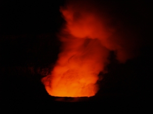
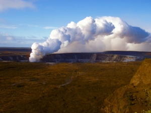
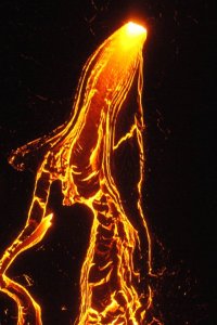
Lava Flowing Down the Pali to the Waikupanaha Ocean Entry, Hawaii Volcanoes National Park

KILAUEA VOLCANO (CAVW#1302-01-)
19.42°N 155.29°W, Summit Elevation 4091 ft (1247 m)
Volcano Alert Level: WATCH
Aviation Color Code: ORANGE

This report on the status of Kilauea volcanic activity, in addition to maps, photos, and webcam images (available using the menu bar above), was prepared by the USGS Hawaiian Volcano Observatory (HVO). Hawai`i Volcanoes National Park status can be found at http://www.nps.gov/havo/ or 985-6000. Hawai`i County Viewing Area status can be found at 961-8093.

Activity Summary for last 24 hours: The final inflation portion of a DI tilt event is in progress. Sulfur dioxide emission rates from the Halema`uma`u and the Pu`u `O`o vents remain high although the emissions from Pu`u `O`o have been decreasing since August. Tephra production from the Halema`uma`u vent remains small. At the east rift eruption site, the flow of lava has paused.

Last 24 hours at Kilauea summit: Weak winds produced poor air quality during most of the last 24 hours. Vent glow was too weak to be recorded by the webcam overnight. This morning, winds above 300 m (1,000 ft) are moving the gas plume to the southwest; winds closer to the ground are weaker resulting in voggy air. GOES-WEST imagery shows the plume moving southwest inland of the coast.

Small amounts of tephra continued to be produced, the collections continue to consistent mostly of glassy spatter. In addition to sounds resembling distant surf, rock falls and rolls could also be made out from the vent.

Sulfur dioxide emission rates remain elevated and variable. The most recent average measurement was 500 tonnes/day on October 24, compared to the 2003-2007 average rate of 140 tonnes/day.

The network of tiltmeters within Kilauea caldera recorded the inflation portion of the ongoing DI tilt event starting at about 2 am. The GPS receiver networks (less sensitive than tiltmeters) recorded small changes but no significant extension or contraction over the past two weeks.

Seismic activity continued to be focused on the south caldera; tremor levels dropped with the start of inflation. A total of 17 earthquakes were located beneath Kilauea or nearby, including 5 beneath the south caldera and none on south flank faults, with the number of RB2S2BL earthquakes increasing to around 50/day.

Last 24 hours at the middle east rift zone vents and flow field: Magma continues to degas through Pu`u `O`o Crater. The most recent sulfur dioxide measurement of 1,100 tonnes/day on October 24 is below the 2005-2007 average of about 2,000 tonnes/day for this vent; Pu`u `O`o emission rates have been slowly declining since early August. No incandescence was observed within the crater overnight.

Pu`u `O`o continues to deflate/collapse. The tiltmeter on the north side of Pu`u `O`o recorded no change in tilt since noon yesterday; the Pu`u `O`o tiltmeter has not yet responded to the DI inflation in progress at the summit. GPS stations spanning the crater (less sensitive than tiltmeters) recorded weak contraction across the crater. Seismic tremor levels near Pu`u `O`o and the TEB vent remain at low values and still haven't responded to the ongoing DI tilt event.

Lava from the TEB vent and the rootless shield complex has paused. The ocean entry plume was very small and only intermittently active yesterday through last night. Incandescence was seen high on the pali above Royal Gardens and from the TEB vent overnight and this morning. GOES-WEST thermal anomalies continued to weaken overnight suggesting that surface flows are no longer active. This morning, CD officials report no active ocean entry.
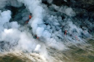
Aerial View of the Lava Flowing Into the Ocean; Hawaii Volcanoes National Park

For more information on visiting Hawaii in general or touring the Big Island in particular, go to www.tourguidehawaii.com and www.lovingthebigisland.wordpress.com. For video of the eruptions in Hawaii volcanoes national Park, go here, here and here.

Tuesday, October 28, 2008

The Weather This Week In Paradise

Reprinted from here.

Point Forecast:
Kailua Kona HI
19.63N 155.95W (Elev. 1217 ft)
Last Update: 4:55 am HST Oct 28, 2008
Forecast Valid: 6am HST Oct 28, 2008-6pm HST Nov 3, 2008


Forecast at a Glance
Today

Isolated Showers Chance for Measurable Precipitation 20%
Isolated
Showers
Hi 82°F
Tonight

Haze
Haze

Lo 68°F
Wednesday

Haze
Haze

Hi 83°F
Wednesday
Night

Haze
Haze

Lo 67°F
Thursday

Isolated Showers Chance for Measurable Precipitation 20%
Isolated
Showers
Hi 83°F
Thursday
Night

Isolated Showers Chance for Measurable Precipitation 20%
Isolated
Showers
Lo 67°F
Friday

Scattered Showers Chance for Measurable Precipitation 30%
Scattered
Showers
Hi 83°F
Friday
Night

Isolated Showers Chance for Measurable Precipitation 20%
Isolated
Showers
Lo 67°F
Saturday

Scattered Showers Chance for Measurable Precipitation 30%
Scattered
Showers
Hi 83°F

Detailed text forecast
Today: Isolated showers after noon. Widespread haze. Cloudy, with a high near 82. South wind around 8 mph. Chance of precipitation is 20%.

Tonight: Widespread haze. Mostly cloudy, with a low around 68. South wind around 8 mph becoming east.

Wednesday: Widespread haze. Increasing clouds, with a high near 83. West wind around 7 mph.

Wednesday Night: Widespread haze. Mostly clear, with a low around 67. East wind around 9 mph becoming south.

Thursday: Isolated showers after noon. Widespread haze. Partly cloudy, with a high near 83. South wind around 8 mph becoming west. Chance of precipitation is 20%.

Thursday Night: Isolated showers before midnight. Widespread haze. Partly cloudy, with a low around 67. East wind around 7 mph. Chance of precipitation is 20%.

Friday: Scattered showers after noon. Widespread haze. Partly cloudy, with a high near 83. West wind around 6 mph. Chance of precipitation is 30%.

Friday Night: Isolated showers. Widespread haze. Partly cloudy, with a low around 67. East wind around 6 mph. Chance of precipitation is 20%.

Saturday: Scattered showers. Widespread haze. Partly cloudy, with a high near 83. West wind around 7 mph. Chance of precipitation is 30%.

Saturday Night: Isolated showers. Widespread haze. Partly cloudy, with a low around 67. South wind around 6 mph. Chance of precipitation is 20%.

Sunday: Scattered showers. Widespread haze. Partly cloudy, with a high near 83. West wind around 7 mph. Chance of precipitation is 30%.

Sunday Night: Isolated showers. Widespread haze. Partly cloudy, with a low around 67. East wind around 7 mph. Chance of precipitation is 20%.

Monday: Scattered showers. Widespread haze. Partly cloudy, with a high near 82. West wind around 7 mph. Chance of precipitation is 30%.

For more information on touring Hawaii in general and visiting the Big Island in particular, please go to tourguidehawaii.com and lovingthebigisland.wordpress.com.

Sunday, October 26, 2008

Franks Big Island Travel Hints #2: South Kona to Ka'u

Frank's Big Island Travel Hints: Kona Coast South of Honaunau to Ka'u: Brought to you by Tour Guide Hawaii.

Driving south on Hwy 11 there isn’t too much to stop and see for several miles, so enjoy the panoramic views. Soon your Tour Guide will give you information about Ho’okena Beach and Milolii.

Ho’okena is a lovely gray sand beach about 5 miles off the main hwy. This is a nice beach for swimming, snorkeling and picnicking. There are some trails to hike and decent restrooms. Camping is also available by permit only. Your Tour Guide will give more information about trails to hike, camping, and where to get snorkel gear and camping permits.

Driving a few miles further, headed toward the volcano park, is the turn off for Milolii. Again about 5 miles off the main highway, Milolii is one of the last fishing villages in Hawaii. On the way down the views are spectacular, so keep your camera handy. Tour Guide will give you lots of history about this area, so make sure you listen to it on the way. If you are up for a short hike, park at the Miloli'i County Beach Park and hike the shoreline trail to beautiful, secluded, empty Honomalino Bay.

As with anywhere you travel, make sure to lock your vehicle when you leave it and don’t leave valuables in plain sight.

Tour Guide will show many other great places to explore as you continue driving south. We’ll jump ahead at this point to the southernmost town in the United States, Na’alehu. This quaint plantation town is a throwback to when sugar cane was the main export. Na’alehu boasts being a favorite spot for Mark Twain to rest and enjoy the old Hawaii lifestyle. The Punalu’u Bakery has become famous throughout the state for their sumptuous sweet bread. These are just two great reasons to stop and take in some of the local flavor.

Driving about 10 miles further south, your Tour Guide will recommend the Punalu’u Black Sand Beach, one of the top 44 sites on the Big Island. This beach is not only famous for the jet black sand but also for the Hawaiian Green sea turtles and the Hawksbill sea turtles who reside nearby. Often you can see these magnificent creatures sunning on the black sand and, at certain times of the year, nesting and laying their eggs. All turtles in Hawaii are endangered species so touching them is forbidden and a $20,000 dollar fine is strictly enforced. Get up close for photos but please leave them alone. Tour Guide will give you some of the rich history of this area as well.

Driving south from Punalu’u Black Sand Beach, you will notice the highway begin to ascend toward the Hawaii Volcanoes National Park. Just after you see the Volcano Park sign, there will be a small parking lot, on the ocean side of the hwy, called the Ka'u Desert Trail Head. A one mile hike on this trail will bring you to the warrior footprints and a petroglyph field. Tour Guide gives the stories and history of this fascinating area.

For more information on touring Hawaii in general and visiting the Big Island in particular, please go to tourguidehawaii.com and lovingthebigisland.wordpress.com.

Friday, October 24, 2008

Mauna Ulu, Hawaii Volcanoes National Park, Big Island Hawaii


Mauna Ulu, or growing mountain is a tall, sloping, shield-shaped hill formed by numerous eruptions along the rift between 1969 and 1974; Mauna Ulu is best seen by walking a few yards past the road beyond the parking lot to where the end of road is covered in fresh lava flows. At Mauna Ulu, visitors can get an intimate look at both pahoehoe and aa lava flow types. Pahoehoe, the less viscous and generally hotter liquid flow, moves fluidly like a river or glacier, the surface folding and molding, like poured taffy, into a ropy structure. Pahoehoe forms generally flat, fairly smooth, hard surfaces. Aa, on the other hand, is much cooler and has exolved much of its dissolved gas, so it is much more viscous, causing the upper surface to fracture into clinker-like boulders and fragments. Flowing aa sounds and looks like a moving pile of hot glass shards; when it cools, it leaves behind rubbly piles of sharp fragments. Fields of pahoehoe and aa make a landscape that look as if Madame Pele has bulldozed her land to flat surfaces, but left these acres of boulder piles here and there.

Pu'u Huluhulu (shaggy hill) is a 150 foot tall cinder cone formed in pre-contact times between Mauna Ulu and Pauahi Crater. There is a fascinating 3 mile round trip hike from the Mauna Ulu parking lot to the top of Pu'u Huluhulu that is marked by cairns (or ahu). From the vantage point of Pu'u Huluhulu's summit, one can see Pu'u O'o (hill of the bird) about 5 miles away. From Pu'u Huluhulu are fine views of Mauna Loa, Kilauea, Mauna Kea, the coastline and Pu'u O'o. Pu'u O'o is a spatter cone built by the fire-fountains erupting along Kilauea's rift zone between 1983 and 1986. Since 1986, the center of eruption has moved about 2 miles further down the rift to a vent called Kupaianaha, or mysterious in Hawaiian. The round trip hike from Mauna Ulu Parking lot to Pu'u Huluhulu and return takes about an hour and a half to two hours.

The hike to the summit of Mauna Ulu is a long, dry, serious hike with some dangers and should only be undertaken by those in good physical condition and experienced at hiking cross-country across broken and hazardous ground.

Written and produced by Donnie MacGowan; videography by Frank Burgess and Donald MacGowan; narrated by Frank Burgess; original musical score written and performed by Donnie MacGowan.

For more information on touring Hawaii in general and visiting the Big Island in particular, please go to tourguidehawaii.com and lovingthebigisland.wordpress.com.

Tuesday, October 21, 2008

Kilauea Visitor's Center, Hawaii Volcanoes National Park


Newly remodeled and updated, the Kilauea Visitors Center is an outstanding resource of information on Hawai'i's volcanoes and the National Park; the not-to-be-missed, definitely first stop in the park you must make. The Center is run by enthusiastic and knowledgeable staff that has the most up-to-date information on viewing the eruption, hiking and camping, bird watching, stargazing and just about any other topic of interest to Park visitors. Available for sale in the Center are maps, guidebooks, books and videos about the volcanoes, Hawai'iana, history, plants and every topic you can imagine pertinent to the Park, even souvenirs. There are free brochures and pamphlets on various trails, attractions, hiking safety and lava viewing hazards and precautions. Starting at 9 a.m. and showing every hour on the hour is a 20 minute informative movie about the Park; the film changes from time to time, but always contains spectacular footage of eruptions, information on Volcanology and the natural and human history of the Park.

The Visitor Center is open daily from 7:45 a.m. to 5 p.m.; there are public restrooms, water and pay phones available. Tuesday evenings the Center is open until 9 p.m. for their After Dark In The Park series of free lectures that start at 7 p.m. Lecture topics range from natural history to geology to topics of local and regional importance and are presented by experts and community leaders. Call 808.985.6017 for the schedule of presentations.

Written and produced by Donnie MacGowan; narrated by Frank Burgess; videography by Donald MacGowan and Frank Burgess; original musical score written and performed by Donnie MacGowan.

For more information about touring Hawaii in general or visiting the Big Island in particular, go to www.tourguidehawaii.com and lovingthebigisland.wordpress.com.

Sunday, October 19, 2008

Kipuka Kahalihi, Hawaii Volcanoes National Park


Kipukas are holes between lava flows where vegetation is saved from being incinerated or buried. At Kipuka Kahalihi, however, much of the vegetation was buried in hot cinders blown here from the 1969 Mauna Ulu fire fountains. Only the tall vegetation was preserved from ash burial and only very hardy species have grown back since the eruption.

Written and produced by Donnie MacGowan; videography by Frank Burgess and Donnie MacGowan. Narrated by Frank Burgess; original musical score written and performed by Donnie MacGowan.

For more information on seeing Hawaii in general and touring the Big Island in particular, visit tourguidehawaii.com and lovingthebigisland.wordpress.com.

Friday, October 17, 2008

Muliwai O Pele, Hawaii Volcanoes National Park

The platform overlooks the remains of a trench that flowed full of lava at the time of the eruption, delivering million of gallons of molten fluid. When trenches such as these become roofed over, they are called lava tubes and the cooled remains are preserved as caves, such as Nahuku, or Thurston Lava Cave up on Crater Rim Drive. When the vent supplying the lava stops producing, these structures drain empty and cool. Large lava cascades may flow at a velocity of several to tens of miles per hour, however, in Hawaii, most flows can easily be outdistanced on foot.

Written and produced by Donnie MacGowan; narrated by Frank Burgess; videography by Donald MacGowan and Frank Burgess; original musical score written and performed by Donnie MacGowan.

For more information on touring Hawaii in general or visiting the Big Island in particular, go to www.tourguidehawaii.com and lovingthebigisland.wordpress.com.

Wednesday, October 15, 2008

Devastation Trail, Hawaii Volcanoes National Park


When Kilauea Iki erupted from vents on Pu'u Pua'i in November of 1959, several feet of hot ash and cinder-sized pieces of pumice fell on the lush fern forest downwind. Devastation trail follows the edge of this inundation, linking the Kilauea Iki Overlook Parking lot with another parking lot at the intersection of Crater Rim Drive with Chain of Craters Road in a wonderful and interesting 0.7 mile, 30 to 45 minute) hike.

During the eruption, fire fountains of molten lava shot up as high as 1900 feet tall from the eruptive rifts. For a sense of scale, the worlds tallest building, the Taipei 101 which is 101 stories tall and 1667 feet high, would be dwarfed by these fire fountains. These immense fountains spread ash, pumice and spatter all around the area, as well as fed liquid lava to the lava pond within Kilauea Iki crater. The spatter was hot and plastic enough to weld together into the spatter cones you see on Pu'u Pua'i, however, the tephra and ash pumice spread out and fell downwind, depositing an immensely thick (as much as 3 meters) blanket when the eruption column collapsed between fountains. This pumice buried lush forest, which is preserved on the eastern side of Devastation Trail. On the west side of the trail is the sterile, moon-like devastation surface of pumice. A few ohia trees, dead and bleached, poke up through the pumice and very gradually some ohia, ohelo and ferns are beginning to recolonize the dead zone. Look for numerous tree molds along the trail in the section about a third of the way from Pu'u Pua'i to the Devastation Trail parking lot.

Pumice results when there is a lot of gas and water dissolved in the liquid lava. As the lava is erupted, pressure is released, the melt begins to cool quickly and the gas is rapidly exolved from the liquid lava—much the way carbon dioxide is exolved as a bubbly froth when you shake a can of soda pop. The spatter and lava in the ponds cool slowly enough for all the gas to escape, and the resultant rock is very dense when it finally solidifies. The pumice, however, chills so rapidly it forms a glass-like, frothy substance because it traps the bubbles. This is why pumice has a low enough density to float on water.

Written and produced by Donald MacGowan. Narrated by Frank Burgess. Videography by Donnie MacGowan and Frank Burgess; original musical score by Donnie MacGowan.

For more information on touring Hawai'i in general and visiting the Big Island in particular, go to www.tourguidehawaii.com and www.lovingthebigisland.wordpress.com.

Monday, October 13, 2008

Hiking to the Summit of Mauna Kea, Big Island of Hawaii


Aloha! I'm Donnie MacGowan and I live on the Big Island of Hawaii. Today, I'd like to take you to the top of Mauna Kea. At 13, 796 feet above sea level, Mauna Kea's summit is the highest point in the State of Hawaii; since its base lies at 19000 feet below sea level, its has a base-to-summit height of 33,000 feet, making it the tallest mountain on earth. It's also one of my most favorite places on earth.

Mauna Kea began forming on the sea floor about one million years ago. Its name means "White Mountain" in the Hawaiian language and it is snowcapped much of the winter, and the summit is covered with permafrost 35 feet deep. During the ice ages, Mauna Kea's summit was glaciated 3 times, starting about 200000 years ago and ending only 11000 years ago. One can see the U-shaped valleys and cirques, striated bedrock, glacial tills covering the summit area and remnants of ice-damned lava flows from those times. There are even the remains of extinct rock glaciers near the summit.

Produced by Donnie MacGowan; original musical score written and performed by Donald B. MacGowan; videography by Donnie MacGowan and Frank Burgess.

For more information on visiting Hawaii in general, or touring the Big Island in particular, please visit www.tourguidehawaii.com and www.lovingthebigisland.wordpress.com.

Thursday, October 9, 2008

Hi'iaka Crater, Hawaii Volcanoes National Park


Hi'iaka Crater is a smallish collapse feature that formed in 1968 and was further modified in 1973 by lava that flowed from both nearby vents and a vent that opened within the lower south wall of the crater. Although the crater itself is uninteresting, there are many fascinating features to be seen by wandering around Hi'iaka and the lava flow, such as tree molds formed where pahoehoe lava backed-up behind trees and formed compression ribbons like poured taffy. By walking about 300 feet southwest from the turnout, one can find the large Koa'e Fault scarp, where it acted as a dam to flows coming out of Hi'iaka Crater in 1973.


Form more information on traveling to Hawaii in general or visiting the Big Island in particular, go to www.tourguidehawaii.com or www.lovingthebigisland.wordpress.com.

Tuesday, October 7, 2008

Frank's Travel Around Hawaii Tip #1

Aloha is a Hawaiian word for hello, goodbye and a word they use for love. In the literal translation, “alo” is life and “ha” is breath. So when you say “Aloha”, and someone returns the greeting, you are sharing the breath of life.

The Big Island of Hawaii is the largest land mass in the state. I fact, all the other Hawaiian islands will fit inside the Big Island and only take up about half of it.

Therefore realize it takes 6-7 hours to drive around this island, if you don’t stop anywhere. I always suggest if you are going to drive and see the sights yourself, split the driving into 3 days and pick up your GPS Tour Guide (808-557-0051).

The first drive day, go to the Hawaii Volcanoes National Park. From Kona it will take 3 hours of non-stop drive time to reach the entrance. Tour Guide has over 50 sights to see inside the park with tons of great info and photos. The park entrance fee is $10.00 per carload and is good for 7 days, so you can go back and see sights you may have missed the first time if you wish. Bring a cooler with sandwiches and lots of water as there are few places inside the park to buy food. If you prefer a hot lunch, the Volcano House is reasonably priced ($15.00 buffet) and has a spectacular view. The Volcano House is also steeped in history and is not to be missed.

I wear shorts, tee shirt and comfortable walking shoes. BUT, also bring my sweat pants and sweatshirt. At 4200 ft. elevation, temperatures can vary from 80 to 45 degrees and weather conditions can change in a matter of minutes, so BE PREPARED. My advice is leave early (7:AM) and expect to get back about dark (6-7 PM). Tour Guide will get you there and back safely and has all the info about hiking, biking, museums and much more.

There are a number of great sights between Kona and the volcano that could be a whole day of sight seeing, all found in your Tour Guide.

When leaving Kona going south, you will enter the coffee country. There are several farms that offer free coffee sampling and tours. Just look for the signs along the highway. Kona Joe’s (visit here and see video) is one of my favorites. They grow their coffee on trellises like fine wine in Napa or Sonoma. Kona Joe’s offers tours, has a coffee bar and gift shop, is immaculately maintained and has breathtaking views of the Kona Coast. For tour times, see their ad in Tour Guide.

Continuing south, brings you to the turn off for Kealakekua Bay (Napo'opo'o Road). At the bottom of this beautiful winding road, turn right to see the Capt. Cook Monument. Tour Guide will give great info about this historic area.

Stay along the coast headed south, on the single lane road for 4 miles, and you will arrive at Pu'uhonua O Honaunau National Historic Park, also known as the “Place of Refuge”. Tour Guide help will make this magical spot come alive; for even more information, visit here.

Sunday, October 5, 2008

Kilauea Eruption Update!

Kīlauea Eruption Status


Reprinted from here.

Photo by Donnie MacGowanPhoto by Donnie MacGowan

Kīlauea Volcano continues to be active. A vent in Halema`uma`u Crater is erupting elevated amounts of sulfur dioxide gas and very small amounts of ash. Resulting high concentrations of sulfur dioxide in downwind air have closed the south part of Kīlauea caldera and produced occasional air quality alerts in more distant areas, such as Pahala and communities adjacent to Hawai`i Volcanoes National Park, during kona wind periods. On September 5, scientists observed a 50-m- (160 ft) diameter lava lake about 100 m (330 ft) below the vent rim on the floor of Halema`uma`u; the lava cannot be seen from the rim of Halema`uma`u Crater or Jaggar Museum Overlook. There have been several small ash-emission events from the vent, lasting only minutes, in the last week.

Pu`u `Ō`ō continues to produce sulfur dioxide at even higher rates than the vent in Halema`uma`u Crater. Trade winds tend to pool these emissions along the West Hawai`i coast, while Kona winds blow these emissions into communities to the north, such as Mountain View, Volcano, and Hilo.

Lava continues to erupt from fissure D of the July 21, 2007, eruption and flows toward the ocean through a well-established lava tube. The ocean entry at Waikupanaha was interrupted twice in the past week in response to back-to-back deflation/inflation (DI) events at Kilauea summit. There were small, short-lived breakouts on the coastal plain early in the week as the eruption recovered from the two pauses in lava supply. The ocean entry had recovered by the second half of the week and hosted frequent small littoral explosions.

Be aware that active lava deltas can collapse at any time, potentially generating large explosions. This may be especially true during times of rapidly changing lava supply conditions. Do not venture onto the lava deltas. Even the intervening beaches are susceptible to large waves generated during delta collapse; avoid these beaches. In addition, steam plumes rising from ocean entries are highly acidic and laced with glass particles. Check Civil Defense Web site (http://www.lavainfo.us) or call 961-8093 for viewing hours.

Mauna Loa is not erupting. Four earthquakes were located beneath the summit this past week. Continuing extension between locations spanning the summit indicates slow inflation of the volcano.

Four earthquakes beneath Hawai`i Island were reported felt within the past week. A magnitude-2.0 earthquake occurred at 8:21 p.m., H.s.t., on Thursday, September 18, 2008, and was located 3 km (2 miles) southeast of Kilauea summit, at a depth of 3 km (2 miles). A magnitude-4.3 earthquake occurred at 5:59 p.m. on Friday, September 19, 2008, and was located 6 km (4 miles) northeast of Ka`ena Point on Kilauea's south flank at a depth of 10 km (6 miles). A magnitude-3.0 earthquake occurred at 7:49 a.m. on Tuesday, September 23, 2008, and was located 32 km (20 mile) northeast of Honoka`a at a depth of 32 km (20 miles). A magnitude-2.2 earthquake occurred at 7:25 a.m. on Wednesday, September 24, 2008, and was located 4 km (3 miles) northeast of Kukuihaele at a depth of 30 km (19 miles).

Visit our Web site (http://hvo.wr.usgs.gov) for daily Kīlauea eruption updates, a summary of volcanic events over the past year, and nearly real-time Hawai`i earthquake information. Kīlauea daily update summaries are also available by phone at (808) 967-8862. Questions can be emailed to askHVO@usgs.gov.

Photo by Donnie MacGowanPhoto by Donnie MacGowan

For more information on touring Hawaii in general and the Big Island in particular, go here and here.

Friday, October 3, 2008

The Weather in Paradise This Week

Reprinted from here.
Point Forecast:
Kailua Kona HI
19.63N 155.95W (Elev. 1217 ft)
Last Update: 5:00 am HST Oct 3, 2008
Forecast Valid: 7am HST Oct 3, 2008-6pm HST Oct 9, 2008


Forecast at a Glance
Today

Isolated Showers Chance for Measurable Precipitation 20%
Isolated
Showers
Hi 80°F
Tonight

Haze
Haze

Lo 66°F
Saturday

Isolated Showers Chance for Measurable Precipitation 20%
Isolated
Showers
Hi 80°F
Saturday
Night

Isolated Showers Chance for Measurable Precipitation 20%
Isolated
Showers
Lo 66°F
Sunday

Isolated Showers Chance for Measurable Precipitation 20%
Isolated
Showers
Hi 80°F
Sunday
Night

Haze
Haze

Lo 66°F
Monday

Isolated Showers Chance for Measurable Precipitation 20%
Isolated
Showers
Hi 80°F
Monday
Night

Haze
Haze

Lo 66°F
Tuesday

Isolated Showers Chance for Measurable Precipitation 20%
Isolated
Showers
Hi 80°F

Detailed text forecast
Today: Isolated showers after noon. Widespread haze. Partly cloudy, with a high near 80. West wind between 6 and 8 mph. Chance of precipitation is 20%.

Tonight: Widespread haze. Mostly clear, with a low around 66. South wind around 7 mph becoming east.

Saturday: Isolated showers after noon. Widespread haze. Partly cloudy, with a high near 80. West wind between 5 and 7 mph. Chance of precipitation is 20%.

Saturday Night: Isolated showers before midnight. Widespread haze. Partly cloudy, with a low around 66. South wind around 7 mph becoming east. Chance of precipitation is 20%.

Sunday: Isolated showers after noon. Widespread haze. Partly cloudy, with a high near 80. West wind between 6 and 8 mph. Chance of precipitation is 20%.

Sunday Night: Widespread haze. Mostly clear, with a low around 66. South wind around 7 mph becoming east.

Monday: Isolated showers after noon. Widespread haze. Partly cloudy, with a high near 80. West wind between 5 and 8 mph. Chance of precipitation is 20%.

Monday Night: Widespread haze. Mostly clear, with a low around 66. South wind around 8 mph becoming east.

Tuesday: Isolated showers. Widespread haze. Partly cloudy, with a high near 80. West wind around 7 mph. Chance of precipitation is 20%.

Tuesday Night: Widespread haze. Mostly clear, with a low around 66. South wind around 7 mph becoming east.

Wednesday: Isolated showers. Widespread haze. Partly cloudy, with a high near 80. West wind between 6 and 8 mph. Chance of precipitation is 20%.

Wednesday Night: Widespread haze. Mostly clear, with a low around 66. South wind around 7 mph becoming east.

Thursday: Isolated showers. Widespread haze. Partly cloudy, with a high near 80. West wind between 5 and 8 mph. Chance of precipitation is 20%.

For more information on touring Hawaii in general, and the Big Island in particular, visit here and here.
 

Casino Bonus no Deposit