Wednesday, April 30, 2008

Aelbert Aehegma, Internationally-exhibited, Hawaii Artist, Cancels Good Will Tour of China

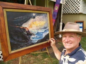
Aelbert Aehegma paints at Tour Guide Hawaii rental office; photo by Donnie MacGowan
Internationally-exhibited, Hawaii artist
Aelbert Aehegma is exhibiting his work
at the Tour Guide Hawaii Rental Office
(see here for map) Thursday-Saturday
afternoons through May. The following
is a press release from the artist
concerning the cancellation of his good-
will trip to China due to their policies
of cultural repression and physical
violence towards the people of Tibet and
other indigenous persons, and de facto
ethnic cleansing of same.

PRESS RELEASE: China 'Goodwill Tour' by
Internationally Exhibited Hawaii Artist
Aelbert Aehegma Canceled:

The Artist Requests:

1~ Citizens of the Free World Boycott
the Olympics In China.

2~ Cancel Travel to China; Other
International Regimes That Suppress
Freedom Of Their People.

3~World Citizens to Limit Purchasing
Chinese Products as well as
Products Of Other Nationalist Regimes
That Deny Basic Human Rights Of Its
Citizens.

Aelbert Aehegma has initiated this
Worldwide request upon being Cut-off
From Communicating With his host, A
Chinese doctor who was arranging The
'Goodwill Tour'; neither by phone nor
private or Government e-mail can she
be reached.

World Citizens cannot look the other
way; Human Rights Violations of the
Tibetans, the Uigers, and other minority
groups in China, Chi Gung Practitioners,
as well as minorities in other non-free
regimes must be confronted, and the
regimes that abuse their People or we
each fail to be part of the greater human
family.

Therefore, Aelbert Aehegma has canceled
his Goodwill 'Tour to China' during
which he was to gift a large mural the
Beijing Museum, visit artists, dignitaries
and children.

The Artist, whose fine art of paintings
and sculptures have been exhibited in
over a dozen countries, has also been
honored to have his art in the First
Art Show in Space aboard the Russian
MIR Space Station in a successful inter-
national effort.

Mele Mai Mahina, Pacifica News Service,
Mr. Aehegma's Public Relations
Manager may be reached for further
Support and Comment at
pacifictalent@yahoo.com, and
aelbertaehegma.com. Search: Aelbert A's
Artsblog & Pacifica News Service.

Tuesday, April 29, 2008

Flowing, glowing, fountaining: Lava erupts into the sea on Kilauea, Big Island of Hawaii

Eruption! Lava Viewing at Hawaii Volcanoes National Park, Big Island of Hawaii

Written directed and produced by Donald B. MacGowan; Narrated by Frank Burgess; Original Musical Score by Donald B. MacGowan

Can you believe this? It's absolutely outstanding and amazing! You can actually walk right up to flowing lava here; see a volcano erupt before your eyes and the molten rock pour into the sea. This has to be one of the four or five most exciting, amazing, wonderful, mystical experiences on earth...you must not miss this!

Mauna Loa is active but not currently erupting. The summit area is slowly inflating, filling with magma and the flanks are subject to frequent minor earthquakes, but no obvious activity is apparent to the visitor. Kilauea, the most active volcano on Earth, started its current eruptive phase in 1983, the longest eruption in history. Since then it has ejected almost 3 billion cubic meters of lava. Flowing from various vents in the rift, most notably Pu'u O'o, in streams and tubes at over 1000 degrees Celsius, much of the lava makes its way into the sea in fiery, steamy explosions or the incredible incongruity of glowing hot lava pouring directly into the sea with little more apparent than a mere bubbling of the water.

Although surface flows and breakouts are frequent and common, there is no guarantee that over any given trip to the Big Island they will be visible or easily accessible to the casual visitor. Since the flow of lava over the moonscape plains and into the roiling sea can be seen nowhere else on earth, it is certainly the most exciting, unique and moving highlight of any trip to Hawai'i. People stand at the edge of the flow and weep at the majesty and mystery of the earth remaking itself; it is wondrous, remarkable and unforgettable. Before planning a hike to see the lava, check with the Rangers at Hawaii Volcanoes National Park for information on the hike length and location of surface flows and a review of safety information.

The lava seems to glow with only a dull petulance during the day and may be less than inspiring until nightfall brings it alive and the madly glowing, fiery goddess within is revealed. Thus knowledgeable hikers plan their hike to commence in the afternoon, reaching their destination at dusk, and to hike back in the dark. The lava streams and tubes migrate back and forth from time to time over a pali and plain of about 8 miles breadth. Sometimes the hike is a few hundred meters, sometimes a few miles, but it is always over an uneven, rough surface, hot during the day even when it rains, cold at night and navigation can sometimes be counterintuitive. The trail at first is marked with cairns and reflectors, but after the viewpoint overlook at a few hundred meters, you are on your own to navigate the basalt wilderness. Take at least 3 quarts of water for each person and two working (check before you leave!) flashlights per person. It is further recommended that you carry sunscreen, snacks, a first aid kit (that rock is SHARP, cuts are common) and wear sturdy hiking boots and long pants. Remember that you are hiking on a highly active volcano, if flowing streams of lava strand you, no rescue is practical or possible; plan, take care and pay strict attention accordingly.
For more information on viewing the lava, visit www.tourguidehawaii.com and www.lovingthebigisland.wordpress.com.

Monday, April 28, 2008

Rent GPS-Guided Tours of the Big Island, Hawaii From Tour Guide Hawaii


Forget obsolete guidebooks and cumbersome maps. Tour Guide Is the most revolutionary travel product ever offered the Hawaii visitor. Go with the GPS Tour Industry leader, Tour Guide, and let us show you Hawaii as you've never seen it before.

Produced by Donnie MacGowan.

Friday, April 25, 2008

Internationally Exhibited Artist Aelbert Aehegma Kailua Kona Art Exhibit Spnsored by Tour Guide Hawaii


Aelbert MC Aehegma and Tour Guide Hawaii cordially invite the public to his exhibit, Thursday-Saturday afternoons and evenings through May, 2008.

Tour Guide Hawaii is sponsoring a showing by Internationally Exhibited artist Aelbert MC Aehegma at their rental shack on Thursday, Friday and Saturday afternoons and evenings through the month of May. Tour Guide Hawaii, a local company and the industry leader in GPS-guided tours, is located n Ali'i Drive at the south end of Kailua Village in a coffee shack on the lawn in front of Huggo's Restaurant (see map here). The artist will be available at the showings.

Aelbert M.C. Aehegma has been exhibited in over a dozen countries and major art cities, including New York City, Geneva, Paris, Washington D.C. and Honolulu. Countries his works have been exhibited in include Spain, New Zealand, Greece, France, Norway, Sweden, Italy, Switzerland and the U.S, as well as the First Art Show in Space aboard The MIR Space Station. His luminous, post-impressionist paintings and stone and wood sculptures are in notable private collections around the world; his works intrigue a broad section of art collectors. His works are included in collections as broad as the hostess of the Playboy Show on T.V. to President George W. Bush.

Aelbert is from a family of many generations of artists. His mission is to share the artist's vision of man's connection to nature, to share the simple beauty naturally within all nature including our own nature. His playful nature beings and the joy of life illuminating from his canvases is alive with myriad color affects, and bathed in light & love.

Aelbert's current exhibits include Museo Angel Orensantz, Spain; American Express Tourism Center, Hilton Waikoloa Village, Hawaii; Hooked Art Gallery, Waimea, Hawaii; Artist-in-Residence, Kona Coast Resort, Hawaii; Artist-in-Residence at Tour Guide Hawaii (Sponsor), Hawaii.

He carves marble and other stones with some hand tools made by his great grandfather over two-hundred years ago, and used by generations in his family.

Aelbert has also worked with metal, wood and other materials. Currently, he is accepting commissions for murals for homes and businesses, as well as monumental indoor and outdoor friezes and sculptures.

Commissions are now being accepted for 2008-2009. Inquires are accepted. Please Call directly to 808 895-7107 Pacific Art Design. Complimentary Consultation and Appraisals are now being offered. To contact by E-mail: pacifictalent@yahoo.com.

Inquires for sample images of special genres such as seascapes, mountainscapes, lavascapes, etc. will be sent by e-mail if requested.

Commissions accepted include: single, couple or group portraits, boat and animal portraits, home, business and estate renderings.

More information on Internationally Exhibited Artist Aelbert MC Aehegma is available here. More information on Tour Guide Hawaii is available here and here.

Internatoanlly Exhibited Artist Aelbert Aehegma

Thursday, April 24, 2008

Frank's Travel Hints # 11: Exploring Deeper Into Hawaii Vocanoes National Park, Big Island, Hawaii


As you continue around the Crater Rim Drive, at Volcanoes National Park, there are dozens of great sights. A more recent crater, erupting with fire curtains in 1974, is Keanakako’i Crater. The pebbles around the rim were formed by froth from the lava as it was blasted into the air and cooled as they fell to the ground. This crater is a bit off-the-beaten-path, but Tour Guide shows the way.

Right along the Crater Rim Drive is the Devastation Trail formed by Kilauea Iki. When the Pu’u Pai vent erupted in 1959 it spewed pumice cinder and scalding ash burying the rainforest some ten feet deep. This caused the forested area to die leaving a barren wasteland where little has grown since. Tour Guide will take you on the three quarter mile paved hike, along the edge of this moonscaped region, and give more historical information as well.

At the end of the Devastation Trail is the Pu’u Pai overlook. This spot affords a view of Pu’u Pai (gushing hill) and Kilauea Iki (little Kilauea) and skirts the edge of the desert and rainforest as if some drew a line separating the two. Tour Guide gives the fascinating stories of 1900 foot lava fountains during this episode.

Super Tip: Bring plenty of water. I can’t stress this enough. There are few facilities available on the drives and hikes around the park, so make sure you stock up before leaving the Visitor’s Center. Besides, good hydration will keep you energized for all your fun activities. To your health.

On the east side of Crater Rim Drive is a delightful stop not to be missed, Thurston Lava Tube. Tour Guide will tell you how lava tubes are formed when magma flows underground. It eventually empties leaving cave-like formations. Most lava tubes are very small; however Thurston Lava Tube is quite large. The National Park Service has paved a pathway through the tube, and installed lighting, to make this a 300 yard spelunking adventure for everyone to enjoy. The cave circles so that the entrance and exit end at the parking area. The giant ferns here invited the songs of exotic birds, many of which are found nowhere else in the world. This is one of the few locations where restrooms are available.

One of the best hiking and biking routes is the Escape Road. Built for just what its name implies an alternate road for when the lava will inevitably cut the Chain of Crater Road, it makes a lovely down hill walk or bike ride. Tour Guide will show where to start at the Thurston Lava Tube parking area and end at the Mauna Ulu parking lot. This road meanders through some of the most cool and pristine rainforest to be found.

At the other end of the Escape Road is Mauna Ulu, also accessible from Chain of Craters Road. This spot was formed by numerous eruptions between 1969 and 1974. A few yards down the road, you see the different types of lava formations left from these flows. Tour Guide will explain these types of lava in great detail. Across the expanse lies Pu’u Huluhulu, or shaggy hill. For those that are ready hike, there is a tree mile round trip hike to the top of Pu’u Huluhulu marked by cairns. From the summit, the views of the lava flows and coastline are indescribable.

Tuesday, April 22, 2008

Kuamo'o: Where the Hawai'ian Gods Died on the Kona Coast of the Big Island, Hawaii

Kuamo'o Battle Field and Lekeleke Burial Ground

Melancholy, lonely, desolate; this beach cut into the fresh scar of an a'a flow marks the place where the Hawai'ian gods died at the battle of Kuamo'o. In 1819, the year before the Christian missionaries arrived in Hawai'i, forces loyal to Kamehameha II and Queen Ka'ahumanu fought to overturn the kapu system and the pagan Hawai'ian religion in favor of Christianity. Kahuna Kekuaokalani led the last supporters of the old ways and the old gods and fought a desperate battle here to preserve their ancient way of life, and lost. Their graves, numbering in the several hundreds despite the official-looking marker at the site, are under the numerous, large stone altars erected by the victors over the very spots the warriors fell.

A walk along the dirt road that bisects the battlefield is ineffably sad and a little creepy. However, the road soon climbs into dryland forest along the lava ocean cliffs and provides some memorable hiking and sunset views.

Kuamo'o Battlefield is located at the very end of Ali'i Drive, somewhat appropriately. No facilities.

For more information on exploring the Big Island of Hawaii in general, and the ancient villages and temples of Kona in particular, visit: www.tourguidehawaii.com
and www.lovingthebigisland.wordpress.com.

Produced by Donnie MacGowan.

Thursday, April 17, 2008

Frank's Travel Hints # 10


Let's Go to Hawaii Volcanoes National Park!

About a two hour straight drive from Kona, going south, brings you to the Hawaii Volcanoes National Park. If you have a Golden Eagle Pass your entrance is free. If not, it is only $10.00 per carload to enter the park. The rangers at the gate will give you detailed maps of the area.

Super tip: Your receipt will give you free access to the National Park for seven days.


My first suggestion is to go to the Kilauea Visitors Center and the Jagger Museum. This will give you a nice overview of the park and rangers are there to answer questions. This spot also looks over the majestic Halemaumau Crater. (At the time of this writing, the museum was closed due to a gaseous explosion in the Halemaumau Crater.) Tour Guide will get you to the park and lead you to more than 50 sites. It is also possible that our state bird, the Nene Goose, will be huddled in the parking lots. They are protected as an endangered species, so be careful when parking nearby.

Another great place to visit is the Volcano Art Center. It may seem a strange, but the Volcano Art Center boasts one of the best collections of art in the whole state. World renowned artist in various media are on display as well as theatrical and musical performances.

There is only one restaurant in the park proper, and that is the Volcano House. Built as a lodge in the mid 1800’s, the Volcano House has hosted dignitaries, politicians, sports heroes and movie stars from all over the world. This grand edifice sits right on the lip of Halemaumau Crater and the views from her restaurant are stunning. Tour Guide will give a complete history of how it came to be. The food is good and the prices are reasonable. Bicycle rentals are also available near the lodge.

Crater Rim Drive is a great driving introduction to the park. It encircles the Halemaumau Crater and, for only an 11 mile drive, passes through several dramatic climate zones. You will encounter arid desert, grass savannah, and into tropical rainforest; this loop can easily be done in forty minutes. However, you will want to take more time to appreciate the beauty and majesty of one nature’s most awesome wonders. Tour Guide will suggest short to medium hikes and bicycle trails as well as over 50 historic and geologic sites to visit within the park.

If you are up for some hiking, Tour Guide will lead you to the trail for Waldron Ledge Overlook. This short hike is through the Ohia and fern jungles, shaded most of the way, and can be done on bicycle as well. From this vantage point one can see the active vent, Kilauea Iki, and breathtaking views of the coast.

Along the Crater Rim Drive you will also see many steam vents and sulfur banks. This is where water seeps into crevices and meets the molten magma about a half mile below the surface, is super heated, and returns to the surface as steam. These vents are often accompanied by a “rotten egg” smell common where sulfur is rising with the steam, turning the ground around the vents hues of yellow, green and white.

For more information on visiting Hawaii and the Bi Island in general, and touring Hawaii Volcanoes National Park in particular, go here.

Wednesday, April 16, 2008

Today's Weather in Paradise

Point Forecast: Kailua Kona HI
19.63N -155.98W (Elev. 213 ft)
Last Update: 5:38 am HST Apr 16, 2008
Forecast Valid: 7am HST Apr 16, 2008-6pm HST Apr 22, 2008


Forecast at a Glance
Today

Chance Showers Chance for Measurable Precipitation 30%
Chance
Showers
Hi 80°F
Tonight

Mostly Clear
Mostly
Clear
Lo 65°F
Thursday

Heavy Rain Chance for Measurable Precipitation 30%
Heavy
Rain
Hi 80°F
Thursday
Night

Isolated Showers Chance for Measurable Precipitation 20%
Isolated
Showers
Lo 66°F
Friday

Chance Showers Chance for Measurable Precipitation 30%
Chance
Showers
Hi 82°F
Friday
Night

Haze
Haze

Lo 69°F
Saturday

Chance Showers Chance for Measurable Precipitation 30%
Chance
Showers
Hi 82°F
Saturday
Night

Haze
Haze

Lo 69°F
Sunday

Chance Showers Chance for Measurable Precipitation 30%
Chance
Showers
Hi 81°F

Detailed text forecast
Today: Scattered showers, mainly after noon. Partly cloudy, with a high near 80. Calm wind becoming west around 5 mph. Chance of precipitation is 30%.

Tonight: Mostly clear, with a low around 65. Light west wind.

Thursday: Scattered showers. The rain could be heavy at times. Widespread haze. Mostly cloudy, with a high near 80. Light west wind. Chance of precipitation is 30%.

Thursday Night: Isolated showers. Widespread haze. Partly cloudy, with a low around 66. West wind around 7 mph. Chance of precipitation is 20%.

Friday: Scattered showers. Widespread haze. Mostly cloudy, with a high near 82. West wind around 7 mph. Chance of precipitation is 30%.

Friday Night: Widespread haze. Mostly clear, with a low around 69. North wind around 8 mph.

Saturday: Scattered showers. Widespread haze. Mostly cloudy, with a high near 82. North wind around 8 mph. Chance of precipitation is 30%.

Saturday Night: Widespread haze. Mostly clear, with a low around 69. North wind around 8 mph.

Sunday: Scattered showers. Widespread haze. Mostly cloudy, with a high near 81. North wind around 8 mph. Chance of precipitation is 30%.

Sunday Night: Widespread haze. Mostly clear, with a low around 69. North wind around 8 mph.

Monday: Scattered showers. Widespread haze. Partly cloudy, with a high near 81. North wind around 7 mph. Chance of precipitation is 30%.

Monday Night: Widespread haze. Mostly clear, with a low around 69. North wind around 7 mph.

Tuesday: Scattered showers. Widespread haze. Partly cloudy, with a high near 81. North wind around 6 mph. Chance of precipitation is 30%.

For more information, visit NOAA
National Weather Service Site, here.

For more information on visiting the
Big Island of Hawaii, go to
www.tourguidehawaii.com.

Tuesday, April 15, 2008

Is Pele teasing us, revealing yet another facet of her personality?

Volcano Update

Reprinted from the USGS Volcano Watch webpage.

Strong trade winds fan the gas-and-ash plume from Halema`uma`u in this early morning photo from the Steaming Bluff overlook.  March 31, 2008
Strong trade winds fan the gas-and-ash plume from Halema`uma`u in this early morning photo from the Steaming Bluff overlook. March 31, 2008

Hundreds of visitors are driving to Kalapana each day to see the ocean entries of Kilauea's east-rift lava flows. As these visitors watch the flows, they may be under the impression that the hazards are calculable and that slow and steady streams of lava into the ocean characterize the nature of eruptions at Kilauea. The explosion that occurred at the summit on March 19th reminded us all that Kilauea can also be an explosive volcano.

Large explosions in Hawaii's geologic history are recorded by the ash deposits that blanket the region surrounding Kilauea. These ash deposits are as recent as 1924 and as old as 40,000 years ago.

From the 1500s to the early 1800s, a number of explosions at Kilauea punctuated its terrain. The eruption of 1790 is of particular note because of its association with the explosion that killed about a third of chief Keoua's warriors going to battle chief Kamehameha in the Ka`u district to the south. The event contributed to the fall of Keoua and, in turn, to the ascent of Kamehameha as the first ruling monarch of the Hawaiian Islands.

The 1924 eruption of Halema`uma`u was the most recent, and most well-documented, explosive event at Kilauea. An excellent article describing this eruption can be read online at http://hvo.wr.usgs.gov/kilauea/history/1924May18/.

But what of the character of the March 19th explosion? Is it much different than earlier Kilauea explosions? Our answer to this question is uncertain because of the size of the explosion. By Kilauea's standards, the March 19th explosion was tiny. We currently estimate that the initial explosion excavated on the order of 10,000 tons of rock from Kilauea. By comparison, the 1924 eruption excavated on the order of a million tons of rock. The 1790 eruption is known to have been larger than the one in 1924 and the known prehistoric explosions even larger.

The larger the explosion, the more likely its products, like ash, can be preserved. Because the records of past explosive events, like the one on March 19th, may have been literally blown away, we can only compare it to the large, previously recorded explosions in Kilauea's history. We're currently observing this problem today. Much of the ash that fell from the initial explosion on March 19th is being swept away into the Ka`u desert and out into the ocean. If not for our monitoring records-both automated and human observations around the clock-this event may not even be identifiable in the future.

The 1924 and 1790 eruptions differed from the current one in that they were not only larger, but phreatic. This class of eruption occurs when ground water interacts with super-heated rocks and magma, forming steam that explodes under pressure. The March 19th explosion contained none of the hallmarks of a phreatic explosion, such as wet ash and mud pellets, or lapilli. Instead, the ash produced was dry and consisted largely of lithics, or rock fragments, and glass particles from the magma below the surface.

The exact mechanism that caused the March 19th explosion is currently being investigated, described, and refined. But the important conclusion that we can now draw is that these smaller explosions may be a normal part of Kilauea's character that we have not recognized. The volcano reveals itself to us by degrees, keeping us guessing, tantalizing us to explore, inquire, and uncover its mysteries.

Activity update

Kilauea summit and Pu`u `O`o continued to deflate. Sulfur dioxide emission rates at the summit have decreased over the past week but are still elevated; seismic tremor levels have remained elevated at several times background levels. Earthquakes were located primarily beneath Halema`uma`u Crater and the adjacent areas, the southwest rift zone, and the south flank faults.

Lava from the 2007 Thanksgiving Eve Breakout (TEB) flow, erupting from fissure D of the July 21 eruption, continues to flow through what remains of the Royal Gardens subdivision and across the coastal plain. On Wednesday, March 5, the flow entered the ocean (Waikupanaha entry) in the vicinity of Kapa`ahu. The Waikupanaha delta has since grown to a width of about 1,000 m (3,280 ft) and has multiple entry points. On March 15, another branch of the flow reached the ocean (Ki entry) farther to the east, within a few hundred meters of the lava viewing area. As of Thursday, April 3, both the Waikupanaha and Ki entries remained active.

The public should be aware that the ocean entry areas could collapse at any time, potentially generating large explosions in the process. The steam clouds rising from the entry areas are highly acidic and laced with glass particles. Do not venture onto the lava deltas. Even the intervening beaches are susceptible to large waves suddenly generated during delta collapse; these beaches should be avoided. Check the County of Hawai`i Civil Defense website (http://www.lavainfo.us) for information on public access to the coastal plain and ocean entry.

In the past few weeks, sporadic breakouts have burst from the lava tube on the steep slopes within the Royal Gardens subdivision; however, their size and frequency seem to have diminished over the past week. Closer to the TEB vent, on the south side of Kupaianaha, an area of recent persistent breakouts on the northeast side of the shield complex was observed to be inactive on April 3.

Weak incandescence has been intermittently observed at night in Pu`u `O`o in the past week. As in years past, Pu`u `O`o likely is serving as a large chimney, beneath which lava is briefly stored and substantially degassed on its way to the eruption site.

On March 11, a new fumarole appeared low on the southeast wall of Halema`uma`u Crater, within Kilauea's summit caldera. The new vent is located directly beneath the Halema`uma`u Overlook about 70 m (230 ft) down. At 2:58 a.m. on March 19, a small explosion occurred from this fumarole. The explosion scattered rock debris over an area of about 75 acres, covering a narrow section of Crater Rim Drive, the entire Halema`uma`u parking area, and the trail leading to the overlook. The overlook was damaged by rocks that reached up to 90 cm (3 ft) across. No lava was erupted as part of the explosion, suggesting that the activity was driven by hydrothermal or gas sources. The new explosion pit continues to vigorously vent gas and ash, with the plume alternating between brown (ash-rich) and white (ash-poor). Fresh lava spatter, Pele's tears and Pele's hair have been collected at the rim, indicating that magma resides at shallow depths in the new conduit.

Sulfur dioxide (SO2) emission rates from the summit area have been substantially elevated up to 10 times background values since early January; the emission rates for the past week have been decreasing but are still elevated. The increase in sulfur dioxide emission rates at the summit means that SO2 concentrations are much more likely to be at hazardous levels for visitor areas downwind of Halema`uma`u, especially during weak wind conditions or when winds blow from the south. Most people are sensitive to sulfur dioxide at these levels, especially children, individuals with asthma, chronic obstructive pulmonary disease (COPD), or other breathing problems. Stay informed about SO2 concentrations in continuously monitored areas (Jaggar Museum and Kilauea Visitor Center) by visiting the Kilauea Visitor Center and the web at:
http://www2.nature.nps.gov/air/webcams/parks/havoso2alert/havoalert.cfm. To minimize these potentially harmful effects, Hawai`i Volcanoes National Park has closed all access to the southern half of Kilauea caldera.

One earthquake beneath Hawai`i Island was reported felt within the past week. A magnitude-1.5 earthquake occurred at 4:01 a.m., H.s.t., on Monday, March 31, 2008, and was located 13 km (8 miles) southeast of Kilauea summit at a depth of 6 km (4 miles).

Mauna Loa is not erupting. No earthquakes were located beneath the summit. The rate of extension between locations spanning the summit, indicating inflation, has decreased to values below current detection limits.

Visit our Web site (http://hvo.wr.usgs.gov) for daily Kilauea eruption updates and nearly real-time Hawai`i earthquake information. Kilauea daily update summaries are also available by phone at (808) 967-8862.

For more information on visiting visiting Hawaii in general and touring the volcano in particular, go to www.tourguidehawaii.com and www.lovingthebigisland.wordpress.com.skip past bottom navigational bar

myspace graphic at Gickr
pimp myspace

One might ask why one would want to reneder a video into GIF annimation. One might, but one would be a total noob to do so. Beacuse it's cool, dude...check it out!

Go to: http://gickr.com/from_youtube!

Monday, April 14, 2008

Hapaiali'i Heiau: Where warriors become Chiefs, Big Island, Hawaii


The remains of Hapaial'i Heiau (Temple for Elevating Chiefs), a heiau associated with ceremonies involving changes in rank of Ali'i, lie on the grounds of the Keauhou Ohana Beach Resort, across the narrow tidal inlet from Ke'eku Heiau. Not much is known about this Heiau; some traditions hold that it predates Ke'eku Heiau; others maintain it was built around 1812 by Kamehameha the Great.

To reach Hapaiali'i Heiau, park either in the Kahalu'u Beach Park or at Keauhou Ohana Beach Resort. From Kahalu'u, walk onto the Keauhou Ohana Beach Resort property through the gateway in the fence between them and follow the asphalt path to the pool deck, through the lobby of the resort and join the paved path that runs along the end of the Resort driveway. From the Resort parking lot, walk up the drive to the paved path that runs along the end of the driveway. Following along this path, one passes Punawai Spring first, then, where the path runs around the end of the tennis courts the homesite of the Mo'o Twins. Continuing on the path until it ends at a broken concrete bridge among "No Trespassing" signs, the Hapaial'i Heiau is immediately between you and the ocean; all that remains of this once impressive temple are an unpresupposing stack of stones and some tumbling walls. Remember that these are holy religious sites to modern native Hawai'ians; to not trespass, walk or climb on the temple proper; take nothing but photographs, leave nothing but footprints.

For more information on exploring the ancient temples of Hawaii, visit www.tourguidehawaii.com, www.lovingthebigisland.wordsmith.com and www.tourguidehawaii.blogspot.com

Produced by Donald B. MacGowan

Monday, April 7, 2008

Euption! Lava Viewing at Hawaii Vocanoes National Park, Big Island of Hawaii

Written directed and produced by Donald B. MacGowan; Narrated by Frank Burgess; Original Musical Score by Donald B. MacGowan

Can you believe this? It's absolutely outstanding and amazing! You can actually walk right up to flowing lava here; see a volcano erupt before your eyes and the molten rock pour into the sea. This has to be one of the four or five most exciting, amazing, wonderful, mystical experiences on earth...you must not miss this!

Mauna Loa is active but not currently erupting. The summit area is slowly inflating, filling with magma and the flanks are subject to frequent minor earthquakes, but no obvious activity is apparent to the visitor. Kilauea, the most active volcano on Earth, started its current eruptive phase in 1983, the longest eruption in history. Since then it has ejected almost 3 billion cubic meters of lava. Flowing from various vents in the rift, most notably Pu'u O'o, in streams and tubes at over 1000 degrees Celsius, much of the lava makes its way into the sea in fiery, steamy explosions or the incredible incongruity of glowing hot lava pouring directly into the sea with little more apparent than a mere bubbling of the water.

Although surface flows and breakouts are frequent and common, there is no guarantee that over any given trip to the Big Island they will be visible or easily accessible to the casual visitor. Since the flow of lava over the moonscape plains and into the roiling sea can be seen nowhere else on earth, it is certainly the most exciting, unique and moving highlight of any trip to Hawai'i. People stand at the edge of the flow and weep at the majesty and mystery of the earth remaking itself; it is wondrous, remarkable and unforgettable. Before planning a hike to see the lava, check with the Rangers at Hawaii Volcanoes National Park for information on the hike length and location of surface flows and a review of safety information.

The lava seems to glow with only a dull petulance during the day and may be less than inspiring until nightfall brings it alive and the madly glowing, fiery goddess within is revealed. Thus knowledgeable hikers plan their hike to commence in the afternoon, reaching their destination at dusk, and to hike back in the dark. The lava streams and tubes migrate back and forth from time to time over a pali and plain of about 8 miles breadth. Sometimes the hike is a few hundred meters, sometimes a few miles, but it is always over an uneven, rough surface, hot during the day even when it rains, cold at night and navigation can sometimes be counterintuitive. The trail at first is marked with cairns and reflectors, but after the viewpoint overlook at a few hundred meters, you are on your own to navigate the basalt wilderness. Take at least 3 quarts of water for each person and two working (check before you leave!) flashlights per person. It is further recommended that you carry sunscreen, snacks, a first aid kit (that rock is SHARP, cuts are common) and wear sturdy hiking boots and long pants. Remember that you are hiking on a highly active volcano, if flowing streams of lava strand you, no rescue is practical or possible; plan, take care and pay strict attention accordingly.
For more information on viewing the lava, visit www.tourguidehawaii.com and www.lovingthebigisland.wordpress.com.

Saturday, April 5, 2008

Recent Kilauea Status Reports, Updates, and Information Releases


HAWAIIAN VOLCANO OBSERVATORY DAILY UPDATE
Friday, April 4, 2008 08:10 HST (Friday, April 4, 2008 18:10 UTC)

Reprinted from the US Geological Survey Webpage, here.

KILAUEA VOLCANO (CAVW#1302-01-)
19.42°N 155.29°W, Summit Elevation 4091 ft (1247 m)
Volcano Alert Level: WATCH
Aviation Color Code: ORANGE

This report, in addition to maps, photos, and webcam images (available using the menu bar above), was prepared by the Hawaiian Volcano Observatory (HVO):

Activity Summary for last 24 hours: Kilauea Volcano is active at two locations. At the summit, the Halema`uma`u vent continued erupting ash. Sulfur dioxide emission rates and seismic tremor levels continued elevated to several times background levels. At the coast, lava continued to flow through lava tubes into the ocean at the Waikupanaha and Ki ocean entries.

Hazard Summary: Hazardous conditions exist in the summit area and the area between the rift zone (Pu`u `O`o to Kupaianaha) downslope to the ocean between Kalapana and Kapa`ahu. There is also great beauty to be seen and experienced at safe distances. HVO, Hawai`i Volcanoes National Park, and Hawai`i County Civil Defense strive to make safe viewing possible.

1. Summit: The current increase in sulfur dioxide emission rates at the summit means that SO2 concentrations in the air are likely to be at hazardous levels for areas downwind of emission sources in Halema`uma`u crater. The National Park Service has closed Crater Rim Drive through the south caldera area until further notice (http://www.nps.gov/havo/closed_areas.htm). Most people are sensitive to sulfur dioxide at these levels. Children and individuals with asthma, chronic obstructive pulmonary disease (COPD), or other breathing problems especially should avoid downwind areas. During tradewind conditions (brisk winds from the northeast), concentrations will be highest and most hazardous in the south caldera. During weak or southerly winds, concentrations may be high and hazardous throughout the summit area of Hawai`i Volcanoes National Park and nearby communities. Stay informed about SO2 concentrations in continuously monitored areas at Jaggar Museum and Kilauea Visitor Center (http://www.nature.nps.gov/air/webcams/parks/havoso2alert/havoalert.cfm).

The gas plume also includes fine rock dust downwind of the source. During the past few days, several people have reported a fine grit on their car windshields while driving under or in the ash plume along highway 11 and as far away as South Point. Information on the effects of ash are available at http://www.ivhhn.org/ and http://volcanoes.usgs.gov/ash/.

The possibility of future small explosions or eruption of lava from Halema`uma`u Crater cannot be ruled out.

2. Pu`u `O`o/July 21/TEB flow field: Vent areas and lava channels are hazardous and conditions can change rapidly. Sulfur dioxide emissions from Pu`u `O`o are high and result in hazardous concentrations downwind. Access to the 7/21 eruption site in the Kahauale`a Natural Area Reserve is closed (see http://www.state.hi.us/dlnr/chair/pio/HtmlNR/07-N076.htm). Wao Kele o Puna is also closed.

There continues to be a threat from lava flows to anyone within Royal Gardens subdivision and the coastal plain. As long as lava flows are active south of fissure D, the subdivision is within likely paths of future flows. The rootless shields, which are now less than two miles from the subdivision, can collapse and release lava flows that advance that distance within a few days. Tube- or channel-fed lava flows established within the subdivision and on the coastal plain remain a threat due to tube ruptures which can produce new lava flows. Lava flows advancing through vegetation are hazardous and can produce fire and methane explosions that propel chunks of lava and rock several feet into the air. Hawai`i County Civil Defense has been notified and is taking appropriate measures (www.lavainfo.us).

Lava entering the ocean poses two additional hazards - potential collapse and laze. Lava entering the ocean builds a delta over its own rubble that is extremely unstable. That delta can collapse without warning and expose very hot surfaces to waves which can explode and throw rock debris up to one-quarter mile inland. For these reason, spectators should avoid the delta and the area one-quarter mile inland. The interaction between seawater and lava produces a steam plume laced with acids and fine particles of volcanic glass or \'laze\' that is unhealthy if inhaled and can produce skin or eye irritation if contacted. Hawai`i County continues to open a public viewing area between 2 and 10 pm with the last car allowed in at 8 pm. For details, see www.lavainfo.us or call 961-8093.

TEB lava flows at the coast as of yesterday evening (from combined HVO and NPS eruption crew reports): Lava continued to flow into the ocean at 3 points - east and west Waikupanaha and Ki ocean entries. West Waikupanaha entry was most vigorous with the Ki entry increasing in vigor in the evening. A sluggish surface flow was active on the 1990 delta below the old sea cliff. Yesterday's overflight documented three tube breakouts on the coastal plain within one mile of the coast, but none had entered unburned kipuka areas. There was no other surface activity on the coastal plain.

Last 24 hours in the area of the east rift zone that includes Pu`u `O`o and the TEB vent: Incandescence was seen from a small skylight adjacent to the TEB vent and from top of a nearby rootless shield. Early this morning, a small breakout occurred within the rootless shield complex. The lava tube system seems to be stable and transports lava efficiently to the ocean entries.

Diffuse incandescence was observed overnight in Pu`u `O`o crater by webcam as has become common over the last several nights. It was not possible to distinguish any tilt signal besides the daily oscillations and rain effects. GPS receivers on opposite sides of the crater recorded no extension or contraction above error since March 27. Seismic tremor levels were at low values. The SO2 emission rate was about 1,530 tonnes/day when last measured on April 1.

Last 24 hours at Kilauea summit: Eruption of ash continued with a white plume most of the day and into this morning. We are increasingly confident that the white plume is producing less ash but that the ash includes an increasing amount of volcanic glass. The base of the plume again glowed dimly and incandescent fragments were sporadically ejected overnight but most fell back into the vent. Seismic tremor levels continued to be elevated to several times background values. The summit tiltmeter network recorded typical daily oscillations with possible weak deflation of a source beneath the south caldera. Two small earthquakes were located beneath Halema`uma`u Crater, one beneath the southwest rift zone, one beneath the east rift zone, and 4 on south flank faults.

The sulfur dioxide (SO2) emission rate from the summit continued to be elevated and was about 480 tonnes/day on April 2, compared to a background rate of between 150-200 tonnes/day. Wednesday's emission rate measurement was the lowest since Feb. 13, 2008. Weakened trade winds yesterday permitted SO2 concentrations to peak at 0.4 ppm at Jaggar Museum just after noon but remain below 0.2 ppm through evening.


Maps, photos, webcam views, and other information about Kilauea Volcano are available at http://volcano.wr.usgs.gov/kilaueastatus.php. A daily update summary is available by phone at (808) 967-8862.

A map with details of earthquakes located within the past two weeks can be found at http://tux.wr.usgs.gov/

A definition of alert levels can be found at http://volcanoes.usgs.gov/2006/warnschemes.html

For more information on visiting the Island of Hawaii and exploring the lava flows of Kilauea Volcano, go to www.tourguidehawaii.com.

Wednesday, April 2, 2008

Hawaii's Sky Tonight


Skywatch Article
April 2008
By Carolyn Kaichi, Bishop Museum

SCIENCE ABOVE AND ABOUT TOWN

There is a major meteor shower this month, the Lyrids, peaking on the evening of Monday, April 21. Unfortunately, an almost-full Moon will shine in the sky all night, making viewing conditions not very ideal for seeing many meteors. The radiant is between Lyra and Hercules but won’t even begin to rise until 9:30 P.M. when the Moon is already well up in the eastern sky. Fortunately, there are many other science related events going on right here in the islands to hopefully satisfy your celestial appetite.

Consider coming to the Bishop Museum Sky Tonight evening program, held every first Friday of the month. This is an hour-long planetarium program concentrating on details of the current month’s sky, with the opportunity to do some telescope viewing if the weather cooperates. Please note that this program has been moved by an hour, now starting at 8:00 P.M., and reservations are required. Call 848-4168 for reservations and information. There is a charge of $4 for non-Bishop Museum members.

The 51st Hawai’i State Science and Engineering Fair is another learning opportunity open to the public on Wednesday, April 2. Amazing and imaginative displays and projects from over 400 students representing 80 schools around the state will be on display at the Neal Blaisdell Center Exhibition Hall from 8:00 A.M. to 7:00 P.M. In addition to these fascinating and sometimes amusing presentations (is your mouth cleaner than your dog’s?), there are several other special exhibits as well. The National Oceanic and Atmospheric Administration (NOAA) is sponsoring a visit by TERRI, a five-foot tall sophisticated robot that sings, tells stories and converses with people. NOAA will also bring an interactive computer exhibit called SciLands—a virtual world in which to explore the Earth in ways most people would never experience. With your virtual personality, you can float on a thundercloud, fly through a hurricane, explore underwater caves and more in the Second Life world. And the Air Force Association will have a full size model of the space shuttle cockpit to walk through. All this is free and open to the public on Wednesday.

On Saturday, April 5, the Bishop Museum hosts the 4th annual Mad About Science Festival from 9:00 A.M. to 5:00 P.M. with the theme, “Healthy Living, Healthy Planet”, focusing on ideas from medicine to Global Warming. The popular behind-the-scenes tours of the museum’s natural sciences collections will be offered and special programs and activities for the entire family will be ongoing throughout the day. In addition, speakers from environmentally-conscious businesses and government agencies in the community will offer talks on keeping our lifestyles, homes and land healthy and safe. NOAA will again make an appearance with TERRI, SciLands demonstrations and hands-on activities for the kids. This is also the last few weeks of the Bishop Museum’s special exhibit, Animal Grossology, which will be open during the Mad About Science Festival.

At the end of the month, on April 27, the University of Hawaii Institute for Astronomy will hold its annual Open House from 11:00 A.M. to 4:00 P.M. Many fascinating astronomy displays, talks and activities will be offered from the Institute and its partners (including the Bishop Museum!). This event is free and open to the public.

Finally, a sneak peak into activities in May—Big Island residents can look forward to AstroDay on Saturday, May 3 at the Prince Kuhio Plaza in Hilo. It’s a day-long celebration of the science, technology and culture in Hawai’i involving participants from all over the state.

MORE ON THE SOUTHERN CROSS

Several readers commented on the fact that one of the featured constellations I wrote about last month, the Southern Cross, was not visible in last month’s map. That is because our map can only show on part of the evening sky and we chose to illustrate the sky only until 10:00 P.M. or so. Unfortunately for last month that just missed the time the Cross rose in the sky. However, since the stars rise around four minutes earlier each night (because of our orbit around the sun) this means that by the end of the month those stars rise roughly two hours earlier. Therefore, the Southern Cross will be on our map this time since it will be up in the south by 10:00 P.M. at the beginning of April!

The Planets

Mercury:

Mercury is traveling behind the sun this month but by the last few days of April emerges low in the western sky at evening twilight. The Pleiades sits near the small planet but that little cluster, along with the other stars associated with the winter sky, are getting progressively lower in the west and more difficult to see as the days get longer.

Venus:

Like Mercury, Venus is also preparing to go behind the sun, although it still has a couple months to go. But it is very close to the sunrise, rising less than an hour before the sun in early April and half an hour in late April. By then it will be too challenging to see until it reappears in the evening sky in late summer.

Mars:

Mars starts off the month on the side of the brother Castor in the constellation of Gemini. As the month progresses, the planet begins to shift eastward toward the other twin Pollux and by the last day of April appears as almost a third “brother” in the constellation. On April 11, a first quarter Moon skims by the Red Planet, making for a nice sight with binoculars or a telescope.

Jupiter:

Jupiter rises in the east by 2:00 A.M. in early April and two hours earlier at the end of the month. It will appear right above a 3rd quarter Moon on April 27, very early in the morning. The giant planet is heading toward opposition in July, so is getting bigger and brighter in our night sky as we approach that date.

Saturn:
Saturn is nicely placed at the “top” of the sky as night falls in the constellation of Leo. The pale golden planet is only a few degrees from the star Regulus, the heart of the lion. Three days after visiting near Mars, the Moon pays a call on the Saturn and Regulus on April 14.

Reprinted from the Bishop Museum Site

Questions? Contact Carolyn Kaichi @ hokupaa@bishopmuseum.org or 847-8203.


Tuesday, April 1, 2008

Today's Weather in Paradise

Point Forecast: Kailua Kona HI
19.63N -156W (Elev. 0 ft)
Last Update: 6:45 am HST Apr 1, 2008
Forecast Valid: 9am HST Apr 1, 2008-6pm HST Apr 7, 2008


Forecast at a Glance
Today

Isolated Showers Chance for Measurable Precipitation 20%
Isolated
Showers
Hi 80°F
Tonight

Isolated Showers Chance for Measurable Precipitation 20%
Isolated
Showers
Lo 73°F
Wednesday

Mostly Sunny
Mostly
Sunny
Hi 77°F
Wednesday
Night

Isolated Showers Chance for Measurable Precipitation 20%
Isolated
Showers
Lo 74°F
Thursday

Mostly Sunny
Mostly
Sunny
Hi 76°F
Thursday
Night

Mostly Clear
Mostly
Clear
Lo 71°F
Friday

Chance Showers Chance for Measurable Precipitation 30%
Chance
Showers
Hi 76°F
Friday
Night

Slight Chance Showers Chance for Measurable Precipitation 20%
Slight Chc
Showers
Lo 72°F
Saturday

Slight Chance Showers Chance for Measurable Precipitation 20%
Slight Chc
Showers
Hi 76°F

Detailed text forecast
Today: Isolated showers before noon. Partly cloudy, with a high near 80. East wind around 14 mph becoming west. Chance of precipitation is 20%.

Tonight: Isolated showers. Partly cloudy, with a low around 73. East wind around 10 mph. Chance of precipitation is 20%.

Wednesday: Mostly sunny, with a high near 77. West wind around 9 mph, with gusts as high as 18 mph.

Wednesday Night: Isolated showers. Partly cloudy, with a low around 74. East wind around 9 mph, with gusts as high as 18 mph. Chance of precipitation is 20%.

Thursday: Mostly sunny, with a high near 76. West wind around 9 mph.

Thursday Night: Mostly clear, with a low around 71. Northeast wind around 9 mph.

Friday: Scattered showers. Mostly cloudy, with a high near 76. West wind around 8 mph. Chance of precipitation is 30%.

Friday Night: A 20 percent chance of showers. Partly cloudy, with a low around 72. East wind around 9 mph.

Saturday: A 20 percent chance of showers. Partly cloudy, with a high near 76. South wind around 8 mph.

Saturday Night: Mostly clear, with a low around 72. East wind around 6 mph.

Sunday: A 20 percent chance of showers. Partly cloudy, with a high near 77. East wind around 6 mph.

Sunday Night: Mostly clear, with a low around 74. Calm wind.

Monday: Sunny, with a high near 77. East wind around 7 mph.


For more information on weather, go here;
for more information on touring the Big Island,
go here and here.
 

Casino Bonus no Deposit