This hike is a fine walk through tall grass, open lava fields and dense, dryland forest, opening onto one of the most pristine ocean beaches in the world. Hiking down to the Captain Cook's Monument from Highway 11 is a great deal of fun—great scenery, wonderful trail that involves complete immersion in Hawai'ian pre- and post-contact history and offers the opportunity for some of the finest snorkeling anywhere on the planet. However, the return hike is hot, thirsty and strenuous; but it is also highly rewarding, granting panoramic views all up and down the Kona Coast. The trail leaves the Napo'opo'o Road just 500 feet below where it drops off Highway 11 near a large avocado tree, right across from a group of three coconut trees, right at telephone pole number 4; parking is tight, but safe. The parking spots and trailhead will show signs of obvious use, usually in the form of recently deposited horse apples from the many trail riders frequenting the area.
The first avocado tree is the harbinger of wonderful things to come, as the trail passes through an area rich in guava, mango, papaya and avocado that are free for the gathering. The 2.5-mile hike takes about 1-1 1/2 hours to descend, somewhat more time to come back up. After following a jeep road for about 50 feet, the trail turns left when the jeep road turns right onto private property. Although overgrown by tall grass for the next half mile, the trail runs more or less straight down the left side of a rock wall to the sea. As the pitch straightens out, keep to the left when the trail first forks and proceed to the beach. You will strike shore several hundred feet northwest of the monument—stroll through the remains of Ka'awaloa Village along the beach on your way to pay homage to Europe's most prolific explorer, James Cook. Remember to bear right at the trail junction when returning uphill, or you will face a long, hot and unpleasant time wandering the a'a fields of Napo'opo'o.
It is also possible, but much less pleasant, to hike most of the way to the monument along the shoreline from Napo'opo'o. This hike is an uninteresting exercise in scrambling over boulders along the beach and contains at least two places that have to be swum in rough water; as such, the safety of this trek is totally at the whim of ocean tides and swells. Highly not recommended.
For more information about visiting Hawaii in general and touring the Big Island in particular, visit here and here.
Monday, June 30, 2008
Saturday, June 28, 2008
Frank's Big Island Travel Hints #4: Waikoloa to Pololu Valley

Driving north past the Waikoloa Beach resorts, the next turn off will take you to the Mauna Lani Resorts. This area has 5 Star to 5 Diamond resorts. It also has some great petroglyph fields near the Orchid at Mauna Lani Resort and some relaxing beaches which are open to the public. Tour Guide gives you turn-be-turn directions to find these wonders easily. The Shops at Mauna Lani offers high end shopping and fine dining.
Another 10 minutes north, on Hwy 19, brings us to a three-way intersection where you’ll make a left turn (north) onto hwy 270 and drive along the Kohala Coast. This northern tip of the island is less populated and less traveled. The first left turn takes you to Pu’ukohola Heiau and Spencer Beach Park.
Pu’ukohola National Historic Park is a large reconstructed heiau (a Hawaiian temple site) with a visitor center and self-guided tour. Your Tour Guide will have all the history and stories about this legendary spot.
Spencer Beach Park is a favorite family beach with lots of facilities. Camping is available, by permit only, and the “no wave” sandy beach is great for young children. It is also a fabulous snorkel spot if you have your own equipment. Tour Guide will tell you about where to get camping permits, snorkel rentals and all the facilities that are available here.
As we continue driving north on Hwy 270, there are several smaller parks along the way. Tour Guide will tell you about all of them and their facilities. For history buffs, Lapakahi State Park is a must stop. This re-creation of an ancient Hawaiian village is fascinating and free. Here you can see how a typical village was laid out and the huts that were used for housing. Whale watching from shore, during the winter months, is also very popular.
Super Tip: When driving in less populated areas, where there are less stores and restaurants, you will save money and frustration by bringing your own food and water. In these locations, even when you do find a store or diner, the items may cost much more. In addition, hours at gas stations vary by day of the week and time of year. It is wise to never let your gas tank get under half-full here. It is also wise to avail yourself of Public restrooms where you find them. Many of the restrooms in the smaller parks have been closed since the earthquake of 2006 and there are none available past the King Kamehameha Statue in the little town of Kapa'au.
Driving just a few minutes farther north, you’ll come to the town of Hawi (pronounced Haw VEE). A cute town with art galleries, souvenir stores, snacks shops and restaurants
(but not much more), Hawi is old Hawaii personified. Just a few minutes northbound brings you to the famous King Kamehameha statue in the small town of Kapa'au (kah pah OW). This is the birthplace of the storied first king to unite all the Hawaiian Islands under one rule. Tour Guide will present tons of info about the shops and restaurants in Hawi and Kapa'au, as well as about King Kamehameha himself.
Drive about 10 more minutes, to the end of the road, to view the Pololu Valley, one of Hawaii's great scenic wonders. From the parking lot at the end of the road you can get some gorgeous photos. If you’re up for some hiking, the trail down to the valley floor is about a 20 minute hike. Bring plenty of water because the hike back up is a hot 45 minutes. Tour Guide will give you more info about what to bring, what to wear and what to expect in the valley itself.
For more information on visiting Hawaii in general and touring the Big Island in particular, go here and here. Tour Guide...for Hawaii fun and Big Island Adventure!
Thursday, June 26, 2008
Weekly Volcano Update: Kilauea's Puzzling Plume
Reprinted from here.
The new Halema`uma`u Overlook vent is now only three months old, and the accompanying plume is relatively small in terms of previous explosive eruptions of Kilauea, but it has been front page news to Hawai`i's citizens and visitors. While watching the voluminous white plume rising thousands of feet into the air by day or admiring the strong glow at night, you're probably wondering what exactly is streaming out of the new vent besides gas. The short answer is ash-rock dust and bits of volcanic glass less than 2 mm (0.08 inches) in diameter. But how do we catch the ash coming out of the plume, and what are we doing with it?
Basically, we let it fall into our scientific laps. Each morning around daybreak, rain or shine, an HVO scientist goes to the Halema`uma`u overlook to collect the ash that has fallen from the plume since the previous morning. After experimenting with different types of ash collectors, 12-quart plastic buckets, weighed down with rocks, emerged as the best.
The contents of the ash collectors are brought back to HVO and weighed, and the average accumulation rate is calculated. The ash is then inspected under the microscope to note variations in its make-up. We're especially interested in the amount of juvenile material (fresh lava) versus the amount of lithic material (bits of older rock or debris from the conduit walls) in each day's collection.
The juvenile material, which comes from lava beneath the crater floor, is sent to our sister volcano observatory near Mount St. Helens for analysis. The results indicate that the chemical composition of the lava at the summit is almost identical to the lava currently erupting from the east rift zone and flowing into the ocean.
Because the ash that is already on the ground can also be blown into our collectors by strong winds, we had to devise ways to minimize collection of the windblown debris while maximizing the collection of ash falling from the plume. An ash collector was placed on the Halema`uma`u overlook fence, elevated about 1 m (3 feet) off the ground. Elevating this collector has proven enough to do the job.
The entire array of collectors are laid out within a few hundred meters (yards) of the vent, positioned to accumulate ash in both trade- and kona-wind conditions.
But that's not all that has been ejected from the new vent. Debris from the three explosions (on March 19, April 9, and April 16), including blocks of older lava as large as 3 feet in diameter and fresh spatter, litters the area around the overlook. Because of this pervasive debris, it would be difficult to tell whether new blocks are ejected from the vent. The solution was to clear a 2.2-m (7-foot) square area of all rock debris larger than 2-3 inches. This "explosion trap" should allow us to identify new material if it is ejected from the vent in this area. None has been seen since April 16.
So, what does all of this dirty, smelly work under the plume tell us? Since juvenile material first appeared in the ash on March 23, it has consistently been seen in the samples. Juvenile material is something geologists look for in volcanic ash, because it tells us that fresh lava is close to the surface. But the appearance of juvenile material, combined with the nature of our visual and thermal observations, still cannot tell us exactly how deep below the floor of Halema`uma`u Crater the lava resides. As we continue to collect the ash each day, we watch and listen for the possibility of seeing fresh lava in the crater again.
Kilauea Volcano continues to be active. A vent in Halema`uma`u Crater is erupting elevated amounts of sulfur dioxide gas and very small amounts of ash. Resulting high concentrations of sulfur dioxide in downwind air have closed the south part of Kilauea caldera and produced occasional air quality alerts in more distant areas, such as Pahala and communities adjacent to Hawaii Volcanoes National Park during kona wind periods.
Pu`u `O`o continues to produce sulfur dioxide at even higher rates than the vent in Halema`uma`u Crater. Trade winds tend to pool these emissions along the West Hawai`i coast. Kona winds blow these emissions into communities to the north, such as Mountain View, Volcano, and Hilo.
The new gas vent observed on May 23 inside Pu`u `O`o has remained active, with no observed change. Lava from the 2007 Thanksgiving Eve Breakout (TEB) flow, erupting from fissure D of the July 21 eruption, continues to flow through what remains of Royal Gardens and across the coastal plain to the ocean in well-established lava tubes. Over the past week, the Waikupanaha ocean entry has remained active, with occasional small explosions and a variable plume.
Be aware that lava deltas could collapse at any time, potentially generating large explosions. This may be especially true during times of rapidly changing lava supply conditions, as have been seen lately. Do not venture onto the lava deltas. Even the intervening beaches are susceptible to large waves generated during delta collapse; avoid these beaches. In addition, steam plumes rising from ocean entries are highly acidic and laced with glass particles. Check Civil Defense Web site (http://www.lavainfo.us) or call 961-8093 for viewing hours.
Mauna Loa is not erupting. Three earthquakes were located beneath the summit. Continuing extension between locations spanning the summit indicates slow inflation of the volcano.
One earthquake beneath Hawai`i Island was reported felt within the past week. A magnitude-3.1 earthquake occurred at 9:26 p.m., H.s.t., on Monday, June 09, 2008, and was located 6 km (4 miles) southwest of Pahala at a depth of 33 km (20 miles).
Visit our Web site (http://hvo.wr.usgs.gov) for daily Kilauea eruption updates and nearly real-time Hawai`i earthquake information. Kilauea daily update summaries are also available by phone at (808)967-8862. Questions can be emailed to askHVO@usgs.gov.
For more iformation on touring HAwaii in general and visiting the Big Island in particular, go here and here.
The Puzzling Plume
 | |
| Geologist collecting ash at the Halema`uma`u overlook fence. The collector is attached to the fence three feet above the ground to reduce sample contamination from windblown material. | |
The new Halema`uma`u Overlook vent is now only three months old, and the accompanying plume is relatively small in terms of previous explosive eruptions of Kilauea, but it has been front page news to Hawai`i's citizens and visitors. While watching the voluminous white plume rising thousands of feet into the air by day or admiring the strong glow at night, you're probably wondering what exactly is streaming out of the new vent besides gas. The short answer is ash-rock dust and bits of volcanic glass less than 2 mm (0.08 inches) in diameter. But how do we catch the ash coming out of the plume, and what are we doing with it?
Basically, we let it fall into our scientific laps. Each morning around daybreak, rain or shine, an HVO scientist goes to the Halema`uma`u overlook to collect the ash that has fallen from the plume since the previous morning. After experimenting with different types of ash collectors, 12-quart plastic buckets, weighed down with rocks, emerged as the best.
The contents of the ash collectors are brought back to HVO and weighed, and the average accumulation rate is calculated. The ash is then inspected under the microscope to note variations in its make-up. We're especially interested in the amount of juvenile material (fresh lava) versus the amount of lithic material (bits of older rock or debris from the conduit walls) in each day's collection.
The juvenile material, which comes from lava beneath the crater floor, is sent to our sister volcano observatory near Mount St. Helens for analysis. The results indicate that the chemical composition of the lava at the summit is almost identical to the lava currently erupting from the east rift zone and flowing into the ocean.
Because the ash that is already on the ground can also be blown into our collectors by strong winds, we had to devise ways to minimize collection of the windblown debris while maximizing the collection of ash falling from the plume. An ash collector was placed on the Halema`uma`u overlook fence, elevated about 1 m (3 feet) off the ground. Elevating this collector has proven enough to do the job.
The entire array of collectors are laid out within a few hundred meters (yards) of the vent, positioned to accumulate ash in both trade- and kona-wind conditions.
But that's not all that has been ejected from the new vent. Debris from the three explosions (on March 19, April 9, and April 16), including blocks of older lava as large as 3 feet in diameter and fresh spatter, litters the area around the overlook. Because of this pervasive debris, it would be difficult to tell whether new blocks are ejected from the vent. The solution was to clear a 2.2-m (7-foot) square area of all rock debris larger than 2-3 inches. This "explosion trap" should allow us to identify new material if it is ejected from the vent in this area. None has been seen since April 16.
So, what does all of this dirty, smelly work under the plume tell us? Since juvenile material first appeared in the ash on March 23, it has consistently been seen in the samples. Juvenile material is something geologists look for in volcanic ash, because it tells us that fresh lava is close to the surface. But the appearance of juvenile material, combined with the nature of our visual and thermal observations, still cannot tell us exactly how deep below the floor of Halema`uma`u Crater the lava resides. As we continue to collect the ash each day, we watch and listen for the possibility of seeing fresh lava in the crater again.
Activity update
Kilauea Volcano continues to be active. A vent in Halema`uma`u Crater is erupting elevated amounts of sulfur dioxide gas and very small amounts of ash. Resulting high concentrations of sulfur dioxide in downwind air have closed the south part of Kilauea caldera and produced occasional air quality alerts in more distant areas, such as Pahala and communities adjacent to Hawaii Volcanoes National Park during kona wind periods.
Pu`u `O`o continues to produce sulfur dioxide at even higher rates than the vent in Halema`uma`u Crater. Trade winds tend to pool these emissions along the West Hawai`i coast. Kona winds blow these emissions into communities to the north, such as Mountain View, Volcano, and Hilo.
The new gas vent observed on May 23 inside Pu`u `O`o has remained active, with no observed change. Lava from the 2007 Thanksgiving Eve Breakout (TEB) flow, erupting from fissure D of the July 21 eruption, continues to flow through what remains of Royal Gardens and across the coastal plain to the ocean in well-established lava tubes. Over the past week, the Waikupanaha ocean entry has remained active, with occasional small explosions and a variable plume.
Be aware that lava deltas could collapse at any time, potentially generating large explosions. This may be especially true during times of rapidly changing lava supply conditions, as have been seen lately. Do not venture onto the lava deltas. Even the intervening beaches are susceptible to large waves generated during delta collapse; avoid these beaches. In addition, steam plumes rising from ocean entries are highly acidic and laced with glass particles. Check Civil Defense Web site (http://www.lavainfo.us) or call 961-8093 for viewing hours.
Mauna Loa is not erupting. Three earthquakes were located beneath the summit. Continuing extension between locations spanning the summit indicates slow inflation of the volcano.
One earthquake beneath Hawai`i Island was reported felt within the past week. A magnitude-3.1 earthquake occurred at 9:26 p.m., H.s.t., on Monday, June 09, 2008, and was located 6 km (4 miles) southwest of Pahala at a depth of 33 km (20 miles).
Visit our Web site (http://hvo.wr.usgs.gov) for daily Kilauea eruption updates and nearly real-time Hawai`i earthquake information. Kilauea daily update summaries are also available by phone at (808)967-8862. Questions can be emailed to askHVO@usgs.gov.
For more iformation on touring HAwaii in general and visiting the Big Island in particular, go here and here.
Tuesday, June 24, 2008
Tour Guide Hawaii Presents: A Walking Tour of Kailua Kona, Big Island, Hawaii
The town of Kailua Kona is the crown jewel on the island of Hawaii and the beating heart of the Kona Coast. A sleepy fishing village not so long ago, Kailua Kona is now the metropolitan center of West Hawaii’s burgeoning economy and exploding population. Founded by King Umi in the 1500’s, Kailua Kona served as the social, religious and political capital of Hawaii for several hundred years. Deeming it the loveliest spot in all the Hawaiian Islands, King Kamehameha the Great ruled his island empire during the final years of his reign from here.
Exploring the downtown area from the King Kamehameha Beach Resort to the Honl’s Beach on the south provides a couple hours pure enjoyment: easy walking along the incomparable turquoise Kona Coast under the warm, sapphire Hawaii sky, past ancient temples, missionary churches, intriguing and unique shops and wonderful restaurants. It is easy, walking here, to understand how one can be completely seduced by the magic of the Big Island.
Kailua Kona is a town made for walking, so start by parking your car. On the north side of town, abundant for-pay parking is available at the King Kamehameha Beach Hotel. Free parking on this end of town is available at Triangle Parking, between Kuakini Highway and Ali’i Drive. About half-way through town, by the Farmer’s Market and Hale Halawai Park, is a large area of free parking. On the south side of town there is abundant free parking at the Coconut Grove shopping area, and at Honl’s Beach.
Let’s start exploring Kailua Kona on the north and work our way south. The thatched structure surrounded by carved wooden idols across from the pier is ‘Ahu’ena Heiau, an ancient and sacred temple site. A temple (or Heiau) has existed on this spot since at least the first millennium, and as recently as the 15th century was occupied by a temple of human sacrifice (or luakini Heiau) dedicated to the war god Kuka’ilimoku. In 1812, King Kamehameha I ordered the heiau enlarged, rebuilt, rededicated as 'Ahu’ena Heiau (“hill of fire”), a temple of peace and prosperity dedicated to the fertility god Lono.
The current structures seen at 'Ahu’ena Heiau were re-built in 1975 under the auspices of the Bishop Museum with financial help from the Hotel King Kamehameha and are constructed to 1/3 the original scale. Here, there is a veritable forest of of carved, wooden sacred images in the “Kona Style”, considered the most refined in all Polynesia.
Three delightful, but tiny, beaches grace the immediate downtown area. The snorkeling from these small beaches is spectacular and strangely uncommon. A beautiful coral garden and vibrant reef fish can be seen snorkeling along the shoreline off 'Ahu’ena Heiau where fish, turtles and eels are abundant in Kailua Bay.
During the winter of 1819 to 1820, Congregationalist missionaries from Boston crossed the Atlantic Ocean enduring 5 months of intense stormy weather while headed for a new life in Hawai’i. In March of 1820, the missionaries sailed into the balmy waters of Kailua Bay and landed at Kamakahonu Rock (eye of the turtle), the “Plymouth Rock” of Hawai’i, which now supports the Kailua Pier.
Mokuaikaua Church, built under the leadership of missionary Asa Thurston between 1835 and 1837, was specifically aligned so that the prevailing breezes would pass through it, but also so that it presented a strong, stone façade to the south and west, the direction from which strong Kona Winds, large storms and hurricanes come. The 112-foot steeple was for many decades the highest structure in Kailua and served as a navigation landmark both for ships at sea and people on land.
The church is constructed of rough-hewn basalt blocks mortared with lime made from burnt coral and bound with kukui nut oil. The corner stones were taken from a heiau built on the same spot by King Umi in the fifteenth century. The interior beams and woodwork are of koa wood. The joints were painstakingly joined with ohi’a wood pins; this is a magnificent example of the architectural style brought to Hawai’i by the missionaries in the 19th century.
The inside of the church is beautiful, cool and inviting, and visitors are welcome between services and on weekdays between sunrise and sunset; admission is free. There is a fascinating mini-museum, small but informative, which is open daily from sunrise to sunset and free tours are conducted from 10 a.m. to noon and 1 to 3:30 p.m. The Museum features exhibits about Hawai’i, the life of the missionaries and contains a scale model of the Brig Thaddeus.
Hulihe’e Palace was built by High Chief (later Governor) James Kuakini in 1838 as a home. For many years, the Palace was used by Hawai’ian royalty as an official residence and summer get-away palace, a place of great galas and parties, but was abandoned to ruin in 1914. Since 1928 the Palace has been operated as a museum by the Daughters of Hawai’i. The Palace Gift Store has many fine art items and hard-to-find books on Hawai’iana.
The museum is open Monday-Friday, 9 a.m. to 4 p.m. and Saturday and Sunday, 10 a.m. to 4 p.m. There are friendly and knowledgeable docents who give free tours, which last about 45 minutes. Admission is $5 for adults, $4 for seniors and $1 for students; photographing inside the museum is forbidden. The palace sustained considerable damage during the earthquake of 2007 and is currently undergoing renovation.
The Kona Inn is of particular historic significance, as it was the first destination resort to open in West Hawai’i and it ushered in the era of tourism along the Kona Coast. Built on the site of Papa ‘Ula (red flats) where a temple of human sacrifice was built by High Chief Umi, today the Kona Inn features many unique and interesting shops and fine restaurants.
The Inn fronts on a large, palm-shaded lawn that leads to a seawall and the ocean. This area is open to the public and is a really grand place for picnicking, watching whales and dolphin and the fabulous Kona sunsets.
The Kailua Farmer’s Market, open Wednesday through Sunday, lies in the parking lot at the corner of Ali’i Drive and Hualalai Road between the Public Library and Hale Halawai Park. The market offers a wide and intriguing variety of fresh produce, hand-made local arts and crafts, Hawai’iana and other types of souvenirs.
The grounds and oceanfront of Hale Halawai Park offer a peaceful, shady place for taking a rest from a busy tour of bustling downtown Kailua, or watching whales and dolphin and the unmatched Kona sunsets. Frequently honu (sea turtles) and boogey boarders can be watched from the seawall. Featuring coconut palms, a neatly manicured lawn, picnic tables and a seawall, the large, Polynesian-style pavilion is used for everything from community gatherings to orchid shows to wedding receptions.
Historic St. Michael’s Church was the first Catholic Church in West Hawai’i. The church offers services in English and Spanish throughout the week, but is primarily of historic interest; the burial plots in the cemetery date from 1855. In 1940, during less “ecologically aware” times, resident priest Father Benno Evers had his parishioners gather 2500 coral heads to build the grotto in front of the church, which covers the church’s original well. The seafloor in Kailua Bay has yet to recover from this pillaging of coral heads. This historic church sustained considerable damage during the earthquake of 2007.
Coconut Grove and Waterfront Row cap the southern end of the Kailua Village shopping district along Ali’i Drive, starting next to the Hale Halawai County Park and ending at the Royal Kona Resort. Newer and more metropolitan that its sister shopping district to the north, Coconut Grove and Waterfront Row have almost everything, from tattoos to souvenirs to Hawai’iana, fine art, musical instruments, sundries, groceries and clothing. The range of cuisines available from restaurants here sweeps from local flavor to Thai, the Hard Rock Cafe to poi crepes to pizza and burgers.
Between the Royal Kona Resort and Hale Kona Kai Resort is a fabulous tide pool that is completely protected from all but the most vicious winter surf. It boasts a moderate population of reef fish and even the occasional turtle! The water sometimes can be a bit murky, but it makes a nice place to take small children or beginning snorkelers. Drive into the entrance for the Royal Kona Resort and continue south past it until you see the blue and white Shoreline Access sign; find a place to park, go down the stairs to the tiny beach and enjoy!
Lovely but compact, Honl’s County Beach Park is a small beach on the southern outskirts of Old Kailua Town. A favorite spot for surfers and boogie boarders it also has very nice snorkeling and is an excellent place to view the sunset and picnic. Remember when going into the water here, there is a fairly strong current to the north, so stay in the shallow reef area close to the beach. Parking is located on both sides of Ali’i Dr., but can be tight here in times of good surf, and crossing Ali’i Dr. drive can be a bit dangerous at certain times of the day. A new bathroom with showers and running water has recently been constructed on the mauka—uphill--side of the road.
Sunday, June 22, 2008
Kuamo'o: Where the Hawai'ian Gods Died, Big Island, Hawaii
Kuamo'o Battle Field/Lekeleke Burial Ground
Melancholy, lonely, desolate; this beach cut into the fresh scar of an a'a flow marks the place where the Hawai'ian gods died at the battle of Kuamo'o. In 1819, the year before the Christian missionaries arrived in Hawai'i, forces loyal to Kamehameha II and Queen Ka'ahumanu fought to overturn the kapu system and the pagan Hawai'ian religion in favor of Christianity. Kahuna Kekuaokalani led the last supporters of the old ways and the old gods and fought a desperate battle here to preserve their ancient way of life, and lost. Their graves, numbering in the several hundreds despite the official-looking marker at the site, are under the numerous, large stone altars erected by the victors over the very spots the warriors fell.
A walk along the dirt road that bisects the battlefield is ineffably sad and a little creepy. However, the road soon climbs into dryland forest along the lava ocean cliffs and provides some memorable hiking and sunset views.
Kuamo'o Battlefield is located at the very end of Ali'i Drive, somewhat appropriately. No facilities.
For more information on exploring the Big Island of Hawaii in general, and the ancient villages and temples of Kona in particular, visit: www.tourguidehawaii.com and www.lovingthebigisland.wordpress.com.
Produced by Donnie MacGowan.
Saturday, June 21, 2008
Frank's Big Island Travel Hints #3: Kona North to Waikoloa and the Kohala Coast

For an interesting day of driving, head north out of Kona on Hwy. 19. About 4 miles out of town we come across the
Continue driving north past the
After the Hualali Resorts, there is about 20 minutes of driving to reach the Waikoloa resorts. Tour Guide will you give info on some secluded beaches along the way. For most of these you will have to park on the hwy and hike to the shore. Since these beaches are so secluded, there will be no facilities. My favorite of these is
Super tip:
Next, as we head north, is the Waikoloa Beach Resorts. This beautiful resort area is cut right out of the jagged lava rock. It boasts the Marriott and Hilton Waikoloa which have shops and fabulous dining. Many coupons and much 9information of the restaurants and shops in this are can be found in two
The King’s Shops and Queen’s Marketplace, on
For more information on visiting Hawaii in general and touring the Big Island in particular, go here and here.
Thursday, June 19, 2008
Directions For Tour Guide Use; find beaches, snorkeling, hiking, Big Island Hawaii
www.tourguidehawaii.com presents GPS-guided tours of the Big Island of Hawaii, featuring beaches, snorkeling, hiking, volcanoes, jungles, whales, bird watching, mountain biking, dolphins, adventure, solitude and independence.
For more information, go to www.tourguidehawaii.com or http://lovingthebigisland.wordpress.com.
Tuesday, June 17, 2008
Now The Big Island Comes Alive in the Palm of Your Hand
Tour Guide GPS-guided tours is the most revolutionary product ever offered the Hawaii visitor, putting the magic of Hawaii at your fingertips...turn-by-turn directions, over 600 video presentations for sites of interest, searchable database--this is one very handy and fun gadget!
Is travel to the Big Island of Hawaii on your horizon? Rent Tour Guide and Hawaii comes alive in the palm of your hand.
Traditional Hawaiian chant written and performed by Frank Burgess.
Tour Guide, where adventure, solitude and independence are our business. For more information, visit www.tourguidehawaii.com and www.lovingthebigisland.wordpress.com.
Sunday, June 15, 2008
Kilauea: Weekly Volcano Watch
Reprinted from the U.S. Geological Survey, here.
What to worry about in Kilauea volcanic emissions...
 | |
| Vog. | |
Even with the focus on sulfur dioxide gas (SO2) and vog, inquisitive individuals have asked about other things emitted by Kilauea volcano. Here's the rest of the story.
First, let's review why we worry about SO2. Kilauea is currently producing up to 4,000 tonnes/day of SO2, resulting in concentrations in air greater than 5 parts per million (ppm) in downwind communities within 50 km (31 miles). Sustained concentrations greater than 0.3 ppm are considered unhealthy. During its journey through the air, the SO2 reacts with oxygen, sunlight, and water to form vog, a mixture of gas and tiny sulfuric acid aerosol droplets. This aerosol mixture appears as a dense haze that obscures Hawaiian scenery and ocean views. The acidic droplets in vog are small enough that they can be inhaled deep in the lung and can pose health problems. In addition to the effects on living creatures, the acid mist can acidify rain and burn the leaves of plants, including many agricultural crops, such as protea, roses, fruits, and vegetables.
The most abundant constituent of eruptive emissions is water, but that's nothing to worry about. We can always use more water, and Kilauea adds more than 4,000 gallons per minute in the form of water vapor to the Earth's water supply. Carbon dioxide (CO2) is the second most abundant constituent in Kilauea emissions. Current CO2 emission rates are about 10,000 tonnes/day. We already have CO2 in concentrations of 0.04 percent and more in the air that we breathe, thanks to human-generated emissions. Fortunately, plants photosynthesize some of this to make oxygen. CO2 is heavier than air and can be a problem in low-lying areas immediately downslope of a volcanic vent when its concentrations exceed 5 percent. Worldwide, human activities produce more than 100 times the amount of CO2 emitted by volcanoes. So although Al Gore is worried about CO2 he isn't blaming volcanoes.
Water, SO2, and CO2 comprise about 99 percent of Kilauea's emissions. All the other constituents together account for the remaining 1 percent and there are many of them. Hydrogen (H2), Hydrogen Chloride (HCl), Hydrogen Fluoride (HF), and Carbon Monoxide (CO) are the principal minor constituents. Of these, H2 and CO are already in the atmosphere at trace levels.
Hydrogen chloride combines with moisture in the air to acidify rain and burn vegetation. HCl is also produced by a chemical reaction where lava enters the sea.
Gaseous hydrogen fluoride (HF) is emitted at rates of around 0.2 tonnes/day from Kilauea and is therefore generally not a direct problem; however, fluoride is deposited on the leaves of downwind vegetation and is not metabolized by the plants. Animals grazing on the tainted forage can get fluorosis and ultimately die if the fluoride amounts are high enough. Very few studies have been done on the fluoride content in Hawai`i vegetation around Kilauea. Fortunately, no fluorosis symptoms have been reported in Hawaiian grazers recently.
But wait, there's more. About one tonne/day, combined, of various metals, such as lead, copper, gold, silver, zinc, bismuth, and mercury are emitted by Kilauea. There are many more components present in trace amounts - in fact, it's probably easier to name elements that are not present in Kilauea emissions than to list all the ones that are.
Taken all together, much of the Earth's metallic ores, oceans, and atmosphere owe their presence to volcanic emissions. We have many things for which to thank volcanoes; we just don't want all of them right in our neighborhood airspace.
Hawaiian volcanoes have always emitted these gases and metals in varying amounts. The emissions are currently high, but probably not higher than during the 251 days of the 1967-68 Halema`uma`u eruption or from the lava lake that existed throughout much of the 19th and early 20th centuries. However, the island population has increased, and land uses have changed substantially since these past long-lived summit eruptions. More people and diverse crops are exposed than ever before. Most of the exposed individuals are unaware of this long history.
HVO continues to watch the summit activity closely and to track the rate of emission of sulfur dioxide, the main gas hazard - and public concern.
Activity update
Kilauea Volcano continued to be active at two locations: a vent in Halema`uma`u Crater is erupting elevated amounts of sulfur dioxide gas and very small amounts of ash. The resulting high concentrations of sulfur dioxide in downwind air have closed the south part of Kilauea caldera and produced occasional air quality alerts in more distant areas, such as Pahala, during trade wind cycles and communities adjacent to Hawai`i Volcanoes National Park during kona wind periods. Pu`u `O`o continued to produce sulfur dioxide at even higher rates than the vent in Halema`uma`u Crater. Trade winds tend to pool these emissions along the West Hawai`i coast. Kona winds blow these emissions into communities to the north, such as Mountain View, Volcano and Hilo.
The new gas vent observed last week inside Pu`u `O`o has remained active, with no notable change. Lava from the 2007 Thanksgiving Eve Breakout (TEB) flow, erupting from fissure D of the July 21 eruption, continues to flow through what remains of the Royal Gardens subdivision and across the coastal plain to the ocean within well-established lava tubes. Over the past week, the Waikupanaha ocean entry has remained active, with occasional small explosions and a vigorous plume.
The public should be aware that lava deltas could collapse at any time, potentially generating large explosions in the process. This may be especially true during times of rapidly changing lava supply conditions, as have been seen lately. Do not venture onto the lava deltas. Even the intervening beaches are susceptible to large waves that are suddenly generated during delta collapse; these beaches should be avoided. In addition, the steam plumes rising from the ocean entries are highly acidic and laced with glass particles. Check the County of Hawaii Civil Defense Web site (http://www.lavainfo.us) or call 961-8903 for information on public access to the coastal plain and ocean entry.
Mauna Loa is not erupting. Three earthquakes were located beneath the summit. Continuing extension between locations spanning the summit indicates slow inflation of the volcano.
Two earthquakes beneath Hawai`i Island were reported felt within the past week. A magnitude-1.9 earthquake occurred at 7:23 a.m., H.s.t., on Friday, May 30, 2008, and was located 2 km (1 mile) southwest of Pu`ulena Crater in Puna at a depth of 3 km (2 miles). A magnitude-2.6 earthquake occurred at 6:29 p.m. on Tuesday, June 3, and was located 6 km (4 miles) north of Ka`ena Point at a depth of 8 km (5 miles).
Visit our Web site (http://hvo.wr.usgs.gov) for daily Kilauea eruption updates and nearly real-time Hawai`i earthquake information. Kilauea daily update summaries are also available by phone at (808) 967-8862. Questions can be emailed to askHVO@usgs.gov.
For more information about touring Hawaii in general, and the Big Island in particular, visit here and here. To see videos about how to view the lava flows on Kilauea, Big Island go here or here.
Friday, June 13, 2008
This Week's Weather In Paradise!
| ||||||||||
| ||||||||||


Wednesday, June 11, 2008
Franks Big Island Travel Hints #2: South Kona to Ka'u
 Frank's Big Island Travel Hints:
 Driving south on Hwy 11 there isn’t too much to stop and see for several miles, so enjoy the panoramic views. Soon your Tour Guide will give you information about Ho’okena Beach and Milolii.
Ho’okena is a lovely gray sand beach about 5 miles off the main hwy. This is a nice beach for swimming, snorkeling and picnicking. There are some trails to hike and decent restrooms. Camping is also available by permit only. Your Tour Guide will give more information about trails to hike, camping, and where to get snorkel gear and camping permits.
Driving a few miles further, headed toward the volcano park, is the turn off for Milolii. Again about 5 miles off the main highway, Milolii is one of the last fishing villages in
As with anywhere you travel, make sure to lock your vehicle when you leave it and don’t leave valuables in plain sight.
Tour Guide will show many other great places to explore as you continue driving south. We’ll jump ahead at this point to the southernmost town in the
Driving about 10 miles further south, your Tour Guide will recommend the Punalu’u Black Sand Beach, one of the top 44 sites on the
Driving south from Punalu’u Black Sand Beach, you will notice the highway begin to ascend toward the
Monday, June 9, 2008
www.tourguidehawaii.com presents: 'Ahu'ena Heiau...Temple of War Gods, Temple of Gods of Plenty
Written directed and produced by Donald B. MacGowan; Narrated by Frank Burgess; Original Musical Score by Donald B. MacGowan.
Ancient ruins? Human sacrifice?
If you are the kind of person who enjoys the excitement of archeology, then this next spot on your tour around the island maybe just what you are looking for. Centuries ago the inhabitants of this region built a series of sacred temples, or heiaus, which were originally used for the purpose of sacrificing human beings to their war god, Kuka'ilimoku. This particular archeological site is called Ahu'ena Heiau, which in Hawaiian means "Hill of Fire".
Take a moment to stop here for a look, who knows what you may find. Who knows what spirits you my encounter. In any event, as you take the time to examine the reconstructed grounds of this particular heiau, keep in mind that to this very day these are places of sanctity and solace for many of the native Hawai'ians. As with all such places, remember to respect this setting as well by not removing anything whatsoever from the site. Meanwhile, as you ponder in your minds just what it is you're looking at, consider a little history...
More information on visiting Hawaii on general and touring the Big Island in particular, including in-depth information on the history, religion, archeology of the Polynesian peoples, go here and here.
Saturday, June 7, 2008
Tour Guide Presents: Akaka Falls, Big Island, Hawaii
There is a reason that Akaka Falls rates as the most visited tourist sites on the island of Hawai'i. Simply put, the 420 foot, free falling plunge of clear water down a fern festooned cliff is an amazing and beautiful site. Leaving the parking lot, the loop trail immediately splits. Going left through fern, ginger, impatiens and bamboo, one reaches Akaka Falls in 5-8 minutes of ambling. If you turn right, the trail loops up and down some hills, through a wonderful jungle of flowers, ferns, heliconia, palms and bamboo to 100 foot tall Kahuna Falls in about 15 minutes of walking; Akaka Falls is then reached by following the same path another 5 minutes and 5-8 minutes after that you are back at the parking lot.
Almost every town in Hawai'i has a "Wainuenue street". From the Hawai'ian syllables "wai" meaning "fresh water" and "nue" meaning "colorful" or "dancing", the word "wainuenue" refers to the rainbow seen in waterfalls. If you are lucky, and approach Akaka Falls on a sunny morning when the sun shines into to grotto, you may be blessed with seeing this lovely Hawai'ian icon, the wainuenue.
When visiting Akaka Falls, be sure to save some time to explore the shops, galleries and cafes of Honomu on the way back to the highway; it's unlike anywhere you've ever been before...guaranteed.
For further information, visit www.tourguidehawaii.com and www.lovingthebigisland.wordpress.com.
Thursday, June 5, 2008
Weekly Volcano Watch
Reprinted from: http://hvo.wr.usgs.gov/volcanowatch/
Kilauea Eruption StatusLava from the 2007 Thanksgiving Eve Breakout (TEB) flow, erupting from fissure D of the July 21 eruption, continues to flow through what remains of the Royal Gardens subdivision and across the coastal plain to the ocean within well-established lava tubes. Over the past week, the Waikupanaha ocean entry has produced vigorous small explosions, with ejecta fallout limited to the new delta.
The public should be aware that lava deltas could collapse at any time, potentially generating large explosions in the process. This may be especially true during times of rapidly changing lava supply conditions, as have been seen lately. Do not venture onto the lava deltas. Even the intervening beaches are susceptible to large waves that are suddenly generated during delta collapse; these beaches should be avoided. In addition, the steam plumes rising from the ocean entries are highly acidic and laced with glass particles. Check the County of Hawai`i Civil Defense website (http://www.lavainfo.us) or call 961-8903 for information on public access to the coastal plain and ocean entry.
Mauna Loa is not erupting. One earthquake was located beneath the summit. Extension between locations spanning the summit, indicating inflation, has resumed following a period of stagnation.
No earthquakes beneath Hawai`i Island were reported felt within the past week.
Visit our Web site for daily Kilauea eruption updates and nearly real-time Hawai`i earthquake information. Kilauea daily update summaries are also available by phone at (808) 967-8862. Questions can be emailed to ask HVO@usgs.gov.
For videos about the Kilaeua eruption, go here and here; for more information about visiting Hawaii in general and touring the Big Island in particular, go here and here.
Tuesday, June 3, 2008
Frank's Travel Around Hawaii Tip #1
 Aloha is a Hawaiian word for hello, goodbye and a word they use for love. In the literal translation, “alo” is life and “ha” is breath. So when you say “Aloha”, and someone returns the greeting, you are sharing the breath of life.
 The Big Island of Hawaii is the largest land mass in the state. I fact, all the other Hawaiian islands will fit inside the Big Island and only take up about half of it.
Therefore realize it takes 6-7 hours to drive around this island, if you don’t stop anywhere. I always suggest if you are going to drive and see the sights yourself, split the driving into 3 days and pick up your GPS Tour Guide (808-557-0051).
The first drive day, go to the
I wear shorts, tee shirt and comfortable walking shoes. BUT, also bring my sweat pants and sweatshirt. At 4200 ft. elevation, temperatures can vary from 80 to 45 degrees and weather conditions can change in a matter of minutes, so BE PREPARED. My advice is leave early (7:AM) and expect to get back about dark (6-7 PM). Tour Guide will get you there and back safely and has all the info about hiking, biking, museums and much more.
There are a number of great sights between Kona and the volcano that could be a whole day of sight seeing, all found in your Tour Guide.
When leaving Kona going south, you will enter the coffee country. There are several farms that offer free coffee sampling and tours. Just look for the signs along the highway. Kona Joe’s (visit here and see video) is one of my favorites. They grow their coffee on trellises like fine wine in
Continuing south, brings you to the turn off for
Stay along the coast headed south, on the single lane road for 4 miles, and you will arrive at Pu'uhonua O Honaunau National Historic Park, also known as the “Place of Refuge”. Tour Guide help will make this magical spot come alive; for even more information, visit here.
Sunday, June 1, 2008
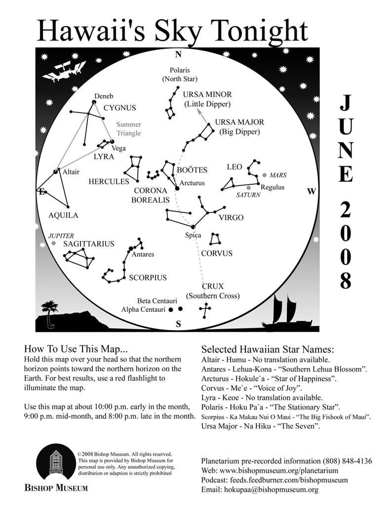
Hawaii's Sky Tonight!
This article reprinted from http://www.astroday.net/bishopsky.html

SKY GEOMETRY
The patterns we see in the sky exist only in our imagination. The points of light we group to create the shapes we call constellations are arbitrary and usually don’t have any connection with each other at all except that they happened to line up in someone’s mind at one time. The 88 “official” constellations are recognized by a group of professionals called the International Astronomical Union to help keep order and structure to the science of astronomy. Otherwise, imagine what chaos might reign—how would anyone know how to distinguish one part of the sky from another if names were random? For instance, the constellation Crater the Cup in the southern sky next to Corvus looks remarkably like my Weber grill, but I can’t very well start referring to it as such. As it is, we sometimes “shorten” the constellations anyway. Sagittarius is often referred to as the Teapot, and part of the Big and Little Bears are called the Big and Little Dippers, respectively.
Informal groupings or segments of constellations are called asterisms. They are usually parts of constellations that are more easily recognized, like the Dippers and the Teapot, and at times the references are updated. Some constellations are simply easier to recognize by these nicknames. I have heard the constellation Boötes the Herdsman referred to as a “bowtie” or “ice cream cone”, which most people relate to better.
Sometimes asterisms include groups of stars or constellations, like the Summer Triangle. Known anecdotally as a basic element of celestial navigation, the Summer Triangle is comprised of the three brightest stars in three separate constellations forming a large, distinctly triangular shape in the sky. First to rise in the east is the star Vega in the constellation Lyra the Lyre. Lyra is a small constellation that takes a bit of effort to imagine the harp-shaped instrument from the parallelogram of stars, but it is an area rich in telescopic sights. One is the famous Ring Nebula, M57—a little smoke-ring object that is the remains of a dying star seen at the center of the ring.
Vega is a white star and the fifth brightest star in the sky. Twelve thousand years ago Vega used to be our North Star, but because the Earth slowly “wobbles” (think of a spinning top, except our wobble is 26,000 years long!) the North Pole points toward different stars periodically. Right now, almost halfway through the wobble’s circle, Polaris is our North Star but in another 14,000 years Vega will take that title again.
Almost two hours after Vega rises the second point of the Triangle appears in the east in Cygnus the Swan. Although this constellation can be easily visualized as a bird, it does have an asterism associated with it. Part of the body and wingspan of the Swan is known as the Northern Cross. The star Deneb is the tail feather of the bird and is the brightest star in that constellation. Opposite from Deneb is an interesting star called Alberio. With a low powered telescope or even binoculars what looks like a single star will split into a beautiful sapphire blue and golden pair of stars.
A half hour later, Altair in Aquila the Eagle makes its appearance over the eastern horizon. Altair and Vega represent two figures in Japanese folklore that are celebrated with a national holiday in the country. Altair is the handsome herdsman Hikoboshi (also known as Kengyu) that fell in love with Orihime (Vega), the beautiful fabric-weaver. Their preoccupation with each other began to interfere with their duties, and as a result the gods separated them across a vast river in the sky. You can see that “heavenly river” in the dark sky as the white band of light called the Milky Way.
Fortunately, the story doesn’t end here—the gods heard the unhappy cries of the two lovers and took pity on them. On the seventh day of the seventh month, the two are united for one day as a flock of magpies build a living bridge to bring the two together. Today this occasion is celebrated by a festive holiday called Tanabata in Japan on July 7, although in early times this date was determined by the lunar calendar.
Following the Summer Triangle (and the parallelogram of Lyra) is the big Square of Pegasus. But because it is not included on this month’s map, I will save that “astro-geometry” lesson for another month!
The Planets
Earth:
Summer kicks off, at least astronomically, with the solstice on June 20. At 2:00 P.M. HST the sun crosses from the southern hemisphere into the northern hemisphere, marked by the celestial equator. (The celestial equator is an imaginary line that extends the Earth’s equator into space)
Mercury:
Mercury is passing in front of the sun for most of the month and will reappear in the morning sky during the last week of June. It hangs over the red “bull’s eye” of Taurus in the light of the rising sun.
Venus:
Venus is behind the sun right now, what is referred to as superior conjunction. It will be another month before it will appear back in the evening sky and blaze in the west after the sun sets.
Mars:
Mars quickly moved from Gemini through Cancer last month and will settle in the constellation Leo during June. Saturn has also been a resident of Leo recently and the two planets are heading for a conjunction in July. You can watch the Red Planet edge closer to yellowish Saturn over the month, with Regulus (the brightest star in Leo) in the middle.
The NASA mission to Mars, called Phoenix (see May’s article) will make its descent to Mars on May 25. Unfortunately I cannot update the status of this mission because this article is filed before this date, but I will definitely talk about Phoenix next month.
Jupiter:
The King of Planets rules the night, shining brighter than any other object besides the Moon this month. Jupiter rises by 10:00 P.M. in early June and about two hours earlier by the end of the month. On June 18, the full Moon enters Sagittarius, the same constellation as Jupiter, and the next evening the waning Moon moves just south of the giant planet.
Saturn:
Look for Saturn high in the west at nightfall during the first half of June, then only about halfway up in that direction by the end of the month. The rings of the gas planet is continuing to tip edgewise to our line of sight and well worth watching over the upcoming months. You will need a telescope to really appreciate this sight, however.
Questions? Contact Carolyn Kaichi @ hokupaa@bishopmuseum.org or 847-8203.
For information ad videos about visiting Hawaii in general and touring the Big Island in particular, visit www.tourguidehawaii.com and www.lovingthebigisland.wordpress.com.
Subscribe to:
Posts (Atom)

