Saturday, August 30, 2008
Ke-awa-iki, Big Island: Hidden Beach, Hike and Snorkeling
Tour Guide Hawaii presents a short video on hiking to Kohala's hidden black sand beach with superb snorkeling and the amazing Ke-awa-iki Golden Ponds. Produced by Donnie MacGowan, and starring Frank Burgess and Bart Hunt.
For further information, visit: www.tourguidehawaii.com or www.lovingthebigisland.wordpress.com.
Thursday, August 28, 2008
Hawaiian Green Sea Turtles: Honu of the Big Island
Called Honu by Hawaii's natives, the Hawaiian Green Sea turtle is beautiful, serene and seeming wise. Though they have swum the oceans for over 200 million years peacefully feeding on algae and invertebrates and living the turtle dream, this highly successful product of amphibian evolution is in grave danger. Loss of habitat, hunting and molestation by humans has conspired to push the Hawaiian Green Sea Turtle to the very verge of extinction.
Protected now by state and federal law, the population of once millions of individuals has been decimated to just a few hundred thousand; although they are making a comeback Hawaii's honu are still very much endangered.
Honu may grow up to 45 inches and weigh as much as 400 pounds at maturity, reached at 25 years of age. Hawaiian Green sea turtles can easily be differentiated from the other near shore sea turtle in Hawaii, the much less common Hawksbill turtle, by counting the scales between the eyes. Hawksbills have four scales between the eyes and Hawaiian Green Sea turtles have two.
Lady honu crawl on shore to lay their eggs, generally after migration to the quieter shores of the French Frigate Shoals, 800 miles northwest of Hawaii, or the black sand beaches on the south end of the Big Island of Hawaii.
Danger to the turtles comes from a myriad of directions; toxic waste, floating balloons and plastic bags, Styrofoam, plastic six-pack rings, abandoned fish nets and line, not to mention getting caught in active fishing operations. As if this weren't bad enough, new and debilitating diseases are afflicting the Hawaiian green sea turtle. Near public beaches, resorts and other areas heavily impacted by human activity as many as 90% of the turtles are dying slow, painful deaths from tumors, infections and other diseases as well as parasites which attack the diseased flesh.
Humans have caused this misery and the decline in these magnificent creatures lives...visitors who wish to see the turtles must take care not to further stress them. Do not approach basking turtles closely, never touch or pick them up. Harassing turtles carries a stiff fine and in any case, touching the turtle is a good way to get a raging salmonella infection. If honu are swimming near where you are, do not approach or chase them; always swim to the side of them, never above (as a predatory shark would) nor below them (so they won't feel that their soft belly is at risk).
Anyone who observes their beauty and grace underwater easily understands how the Hawai'ians base their word for "peace", "honua" on their name for the green sea turtle, "honu".
It is within our grasp, this generation, to save or destroy forever these ancient animals; treat them gently and with respect.
More information is available by visiting www.tourguidehawaii.com or http://lovingthebigisland.wordpress.com.
Tuesday, August 26, 2008
Visit the Keahou Historic District: Homes and Temples of the Kings, Big Island of Hawaii
Kapua Noni Heiau/Canoe Landing/Ku'ula Stones
Located on a small point of land between just makai of the Keauhou Beach Hotel's pool, is the Kapua Noni Heiau, built by the Ali'i Kalanio'pu'u. This walled enclosure was dedicated to ensuring the abundance of fish. Just north of the Heiau is a canoe landing and the sacred bathing pool, Poho'okapo. Between the canoe landing and the Po'o Hawai'i Pond (King's Pond) are two ku'ula stones. Any stone god, carved or natural, large or small, used to attract fish is referred to as pohaku ku'ula. These two ku'ula are named Kanaio and Ulupalakua and were brought by voyaging canoe from Maui in 1751. Look at the larger stone, the one nearer the plaque, to sea the images of a turtle, a fishhook and shark represented on it, using a combination of the natural lines of the stone and engraving. The round hole near the top indicates that this was also a "luakini" stone, or stone for human sacrifice. A loop of rope was passed through the hole, around the victim's neck, and tightened until strangulation was complete. It is not known if human sacrifice at this stone was used as punishment, to propitiate the gods for good fishing, to dispatch enemy combatants for ritual cannibalism, or some combination of these.
To reach the Ku'ula Stones, Heiau and Canoe Landing, park either in the Kahalu'u Beach Park or at Keauhou Ohana Beach Resort. From Kahalu'u walk onto the Keauhou Ohana Beach Resort property through the gateway in the fence between them, and onto the paved path toward the pool deck. From the Resort parking lot, walk up the drive and cross through the lobby to the pool deck. Kapua Noni Heiau is the raised stone platform directly seaward of the pool deck, and is marked by carved wooden. The canoe landing is along the rock-free shoreline directly seaward and to the north of the Heiau. The ku'ula stones are prominent standing stones along the paved path in the garden between the hotel and the Kalanikai Bar and Grill. The Ku'ula Stones and Kapua Noni Heiau are marked by historical information plaques. Remember that these are holy religious sites to modern native Hawai'ians; to not trespass, walk or climb on the temple proper; take nothing but photographs, leave nothing but footprints.
Produced by Donald B. MacGowan.
For more information on exploring Hawaii and unlocking its hidden secrets, visit www.tourguidehawaii.com and www.lovingthebigisland.wordpress.com.
Sunday, August 24, 2008
Tour Guide Hawaii: Self-Guided GPS Tours--An Incredible New Way To Travel
Location Aware technology blended with old-time story-telling; Tour Guide brings you the Island of Hawaii as you've never seen it before.
For rental over the internet and more information, go to www.tourguidehawaii.com. For more information on touring the Big Island of Hawaii, visit www.lovingthebigisland.wordpress.com.
Produced by Donald B. MacGowan.
Friday, August 22, 2008
The Weather in Paradise!
| ||||||||||
| ||||||||||


Tuesday, August 19, 2008
Weekly Volcano Update!
Reprinted from here.
To see recent videos of the Kilauea eruptions, go here, here and here.
In every volcanic paradise, a little vog must fall
 | |
| Area with vog. | |
The new vent in Halema`uma`u Crater at the summit of Kīlauea Volcano has created additional challenges for communities in the Ka`u and Kona districts with regard to air quality. During trade winds, which blow 90 percent of the time during the summer months, Pahala, Na`alehu, Ocean View, and other downwind communities are plagued by high concentrations of both sulfur dioxide (SO2) gas and their associated sulfate particles. Communities farther from the volcano, such as those on the Kona coast, are affected predominantly by particles.
The very worst vog days are frequently characterized by exceedences of EPA regulatory standards for SO2 gas and particulate matter. For these pollutants, 24-hour health standards have been set to protect the general population. For SO2 gas there is also a short-term standard meant to protect visibility, property, vegetation, and animals.
Since the new activity at Halema`uma`u began, the EPA standards for SO2 have been exceeded on numerous occasions in Pahala, and for particulate matter they have been exceeded in both Pahala and South Kona. The Pahala air quality monitoring station, which was installed in August 2007, only measured exceedence of SO2 standards after the opening of the Halema`uma`u vent in March 2008. Exceedence data are available at http://Hawaii.gov/health/environmental/air/cab/index.html.
An air quality monitoring site located at the Hawaiian Volcano Observatory (HVO), less than 2 km (1.2 mi) from the vent, offers an interesting perspective. When trade winds are interrupted, gas emissions from the summit and east rift zone are blown toward this station. Data show that, over the past 7 years, the 24-hour health standard was exceeded 1-9 times per year--on average just a handful of days. However, during the first half of 2008, the standard at this site has been exceeded 21 times.
Preliminary data also show that 2008 HVO wind patterns are consistent with those of previous years. This suggests that the larger number of SO2 events is due to the increase in SO2 emissions from Halema`uma`u, rather than to an increase in non-trade wind days.
The total output of SO2 gas from Kīlauea has increased by about 50 percent since the gas vent at Halema`uma`u appeared. Emissions from the summit jumped from a long-term average of about 200 t/d to the current 500-1000 t/d--an increase of 250-500 percent. Pu`u `Ō `ō, on Kīlauea's east rift zone, is still the predominant source of SO2 emissions, but the relative impact of summit emissions has increased significantly.
During prevailing trade winds, the east rift gas plume is generally blown out to sea, where it is dispersed and diluted before being carried back onshore to impact downwind communities. The Halema`uma`u plume remains onshore and is generally blown through the Ka`u desert to directly affect downwind communities.
During trade wind disruptions, which occur as much as 50 percent of the time during winter months, air quality in windward Hawai`i deteriorates. Communities on the east side of the island will continue to be impacted by the east rift plume as they have been for the past two decades. Communities close to the Halema`uma`u vent and to the north, like Kulani Prison, will most strongly experience the additional impact of the summit plume on these days.
Although Kīlauea's dynamic past suggests that the current situation could change suddenly, there is no indication that the summit eruption will end in the near future. Hawai`i residents are practiced at preparing for natural hazards, such as lava flows, tsunami, floods, and earthquakes. Learning about vog and how it can affect specific areas will help individuals adjust their activities to minimize their exposure to volcanic air pollution. For more information, see the new Frequently Asked Questions about Air Quality in Hawai`i at the USGS-HVO Web site (http://hvo.wr.usgs.gov/hazards/FAQ_SO2-Vog-Ash/main.html).
Activity update
Kīlauea Volcano continues to be active. A vent in Halema`uma`u Crater is erupting elevated amounts of SO2 gas and very small amounts of ash. Resulting high concentrations of SO2 in downwind air have closed the south part of Kīlauea caldera and produced occasional air quality alerts in more distant areas, such as Pahala and communities adjacent to Hawai`i Volcanoes National Park, during kona wind periods. There have been several small ash-emission events, lasting only minutes, in the last week. These are preceded by small seismic events and are probably caused by tiny rock falls within the vent.
Pu`u `Ō`ō continues to produce sulfur dioxide at even higher rates than the vent in Halema`uma`u Crater. Trade winds tend to pool these emissions along the West Hawai`i coast, while Kona winds blow these emissions into communities to the north, such as Mountain View, Volcano, and Hilo. Incandescence continues to be observed at night inside Pu`u `Ō`ō and suggests minor activity from vents within the crater.
Lava continues to erupt from fissure D of the July 21, 2007,eruption and flows toward the ocean through a well-established lava tube. A deformation event at Kīlauea's summit, starting on Tuesday, August 5, choked off the supply of lava to the east rift zone eruption site for several days. The Waikupanaha ocean entry had died by Wednesday, August 6 and the lava tube was observed to be empty on Thursday, August 7. Inflation began at the summit on the afternoon of Friday, August 8, resuming the lava supply to the east rift zone. On Saturday, August 9, lava began to overflow from the Thanksgiving Eve Breakout (TEB) vent and reenter the tube system. Breakouts were observed on the morning of Sunday, August 10, at the top of Royal Gardens subdivision and on the coastal plain. The largest of these coastal plain breakouts created a new short-lived ocean entry west of the main Waikupanaha entry and sent a minor flow into a kipuka on the east margin of the flow field. The coastal plain breakouts, and the new western ocean entry, were inactive by Wednesday, August 13. The main Waikupanaha entry reactivated on Sunday, August 10, resuming its characteristic littoral explosions and vigorous plume.
For more information on touring Hawaii in general, or visiting the eruptions in particular, visit www.tourguidehawaii.com and www.lovingthebigisland.wordpress.com.
Monday, August 18, 2008
Frank's Hawaii Travel Tips #9: Made for Adventure: The Jungles, Volcanoes, Hot Springs and Tidepools of Puna!

Deeper into mysterious Puna!
As you continue along the coast road, you will next encounter
Not far away is
Drive just a few miles further and you come to what used to be the town of
What remain are a few homes and businesses where the road now ends. From here one can see the plume of smoke coming from the vent upslope. Sometimes the lava reaches the ocean about 2 miles from this spot.
A short five minute hike will bring you to
Heading back from Kalapana, you will want to take Highway 130 toward Pahoa. This is your best chance of watching Kilauea erupt. Just a few hundred yards north of Kalapana, is the old turn off to Royal Gardens. This is now the official County of Hawaii Lava Viewing Site. Drive as far as the attendants will allow you, park and walk into where you can safely view the lava flowing into the ocean. Daily updates on the volcano and conditions at site are available at the Hawaii County Lava Viewing Desk, phone number 808.961.8093; more information is here and here.
Farther along the highway to Pahoa, you will see a “scenic turnout” where you can view the Puna Geothermal Vents. Here a company has tapped the natural steam to create electricity from these fumaroles. Tour Guide will show you how, with a short hike off the road, and you can sit in one of these natural sauna vents for some real relaxation.
Now you’re ready to head back to Kona. Take Highway 130 to Highway 11 and go south. If time permits, you may want to stop in
For more information on visiting Hawaii in general and touring the Big Island in particular, go here and here.
Saturday, August 16, 2008
www.tourguidehawaii Presents: Devastation Trail, Hawaii Volcanoes National Park
Written and produced by Donald B. MacGowan; videography by Frank Burgess and Donald MacGowan; Narration by Frank Burgess; Original Music by Donnie MacGowan
When Kilauea Iki erupted from vents on Pu'u Pai in November of 1959, several feet of hot ash and cinder-sized pieces of pumice fell on the lush fern forest downwind. Devastation trail follows the edge of this inundation, linking the Kilauea Iki Overlook Parking lot with another parking lot at the intersection of Crater Rim Drive with Chain of Craters Road in a wonderful and interesting 0.7 mile, 30 to 45 minute) hike.
During the eruption, fire fountains of molten lava shot up as high as 1900 feet tall from the eruptive rifts. For a sense of scale, the world's tallest building, the Taipei 101 which is 101 stories tall and 1667 feet high, would be dwarfed by these fire fountains. These immense fountains spread ash, pumice and spatter all around the area, as well as fed liquid lava to the lava pond within Kilauea Iki crater. The spatter was hot and plastic enough to weld together into the spatter cones you see on Pu'u Pai, however, the tephra and ash pumice spread out and fell downwind, depositing an immensely thick (as much as 3 meters) blanket when the eruption column collapsed between fountains. This pumice buried lush forest, which is preserved on the eastern side of Devastation Trail. On the west side of the trail is the sterile, moon-like devastation surface of pumice. A few o'hia trees, dead and bleached, poke up through the pumice and very gradually some o'hia, ohelo and ferns are beginning to recolonize the dead zone. Look for numerous tree molds along the trail in the section about a third of the way from Pu'u Pai to the Devastation Trail parking lot.
Pumice results when there is a lot of gas and water dissolved in the liquid lava. As the lava is erupted, pressure is released, the melt begins to cool quickly and the gas is rapidly exolved from the liquid lava—much the way carbon dioxide is exolved as a bubbly froth when you shake a can of soda pop. The spatter and lava in the ponds cool slowly enough for all the gas to escape, and the resultant rock is very dense when it finally solidifies. The pumice, however, chills so rapidly it forms a glass-like, frothy substance because it traps the bubbles. This is why pumice has a low enough density to float on water.
For more information about visiting Hawaii in general or touring the Big Island in particular, go to tourguidehawaii.com and lovingthebigisland.wordpress.com.
Thursday, August 14, 2008
tourguidehawaii.com Presents: Thurston Lava Tube, Hawaii Volcanoes National Park
Written and produced by Donald B. MacGowan; videography by Frank Burgess and Donald MacGowan; Narration by Frank Burgess; Original Music by Donnie MacGowan
Nahuku, the Thurston Lava Tube, gives the visitor an opportunity for a close-at-hand inspection of the inner plumbing of a volcano. It also makes for an interesting and unique way to escape the noonday heat or afternoon shower briefly. Lava tubes form when the outer crust of a flowing river of lava begins to cool and crust over, but the lava continues to flow beneath it; when the flow has completely drained away, the lava tube is left behind.
Thurston lava tube is a remarkably large, well-preserved and accessible example of a lava tube-type cave. An easy, 0.3 mile trail (about a 15 minute hike) winds through lush fern forest alive with singing bird and buzzing insects, down into a collapse crater entering the lava tube and slipping about 300 feet through the well-lighted, floored cave, popping up through a skylight in the tube and returning to the parking lot. A very easy walk and certainly a "must see" for any visitor to the park.
When Lorrin Thurston, founder of the Honolulu Advertiser, found the cave in 1913, the roof reportedly was covered with stalactites—it is said that rapacious tourists removed every one in the intervening years.
For more information about visiting Hawaii in general or touring the Big Island in particular, go to tourguidehawaii.com and lovingthebigisland.wordpress.com.
Tuesday, August 12, 2008
Pu'u Loa: Polynesia's Largest Petroglyph Field
Written and produced by Donnie MacGowan; narrated by Frank Burgess. Videography by Donnie MacGowan and Frank Burgess.
Along the side of the centuries-old Ka'u-Puna trail, worn smooth by generations of travelers, in the area of the Hill of Long Life (Pu'u Loa) lies the largest petroglyph field in Polynesia It is estimated that the Pu'u Loa field contains in excess of 15,000 carvings. A one mile segment of this ancient trail, from the parking lot along the Chain of Craters Road to the petroglyphs, has been marked with cairns (or "ahu") by the Park staff to lead visitors to the petroglyphs. As you hike along this trail, notice the smoothness of the lava, the sheen on the trail worn by generations of travelers' feet.
There are many theories concerning the origin and meanings of these carvings but one thing is certain. People stopped here for hundreds of years and left their mark on the stone. Among the designs are simple holes, spirals, concentric circles, human forms and others which are unrecognizable geometric shapes. The hills and swales of pahoehoe surrounding the boardwalk contain thousands more petroglyphs, but due to their fragility, you are advised to remain on the boardwalk to keep from damaging them.
Pu'u Loa, the hill at the margin of the boardwalk, is the place where Hawai'ians came to bury the umbilical chord of their children. People came from all over the Hawai'ian Islands to bury their child's piko, or umbilical chord stump, in this place of "mana" (Hawai'ian for power), the home of the Goddess Pele. Grinding out a cup-shaped hole, the Hawai'ians would place the piko in the ground to insure long life, and good grace from the Goddess, for their child.
Remember that these carvings, though many hundreds of years old, are extremely fragile so remain on the boardwalk—do not step into the petroglyph field, even for a better view, or onto the carvings themselves. The boardwalk passes by hundreds of carvings near enough for you to examine them minutely and photograph the completely. This self-guided tour takes about 1 hour.
For more information about touring Hawaii in general or visiting the Big Island in particular, go to www.tourguidehawaii.com and www.lovingthebigisland.wordpress.com.
Sunday, August 10, 2008
Halema'uma'u: Kilauea's New Show
Produced by Donald B. MacGowan; videography by Frank Burgess and Donnie MacGowan; original musical score by Donnie MacGowan.
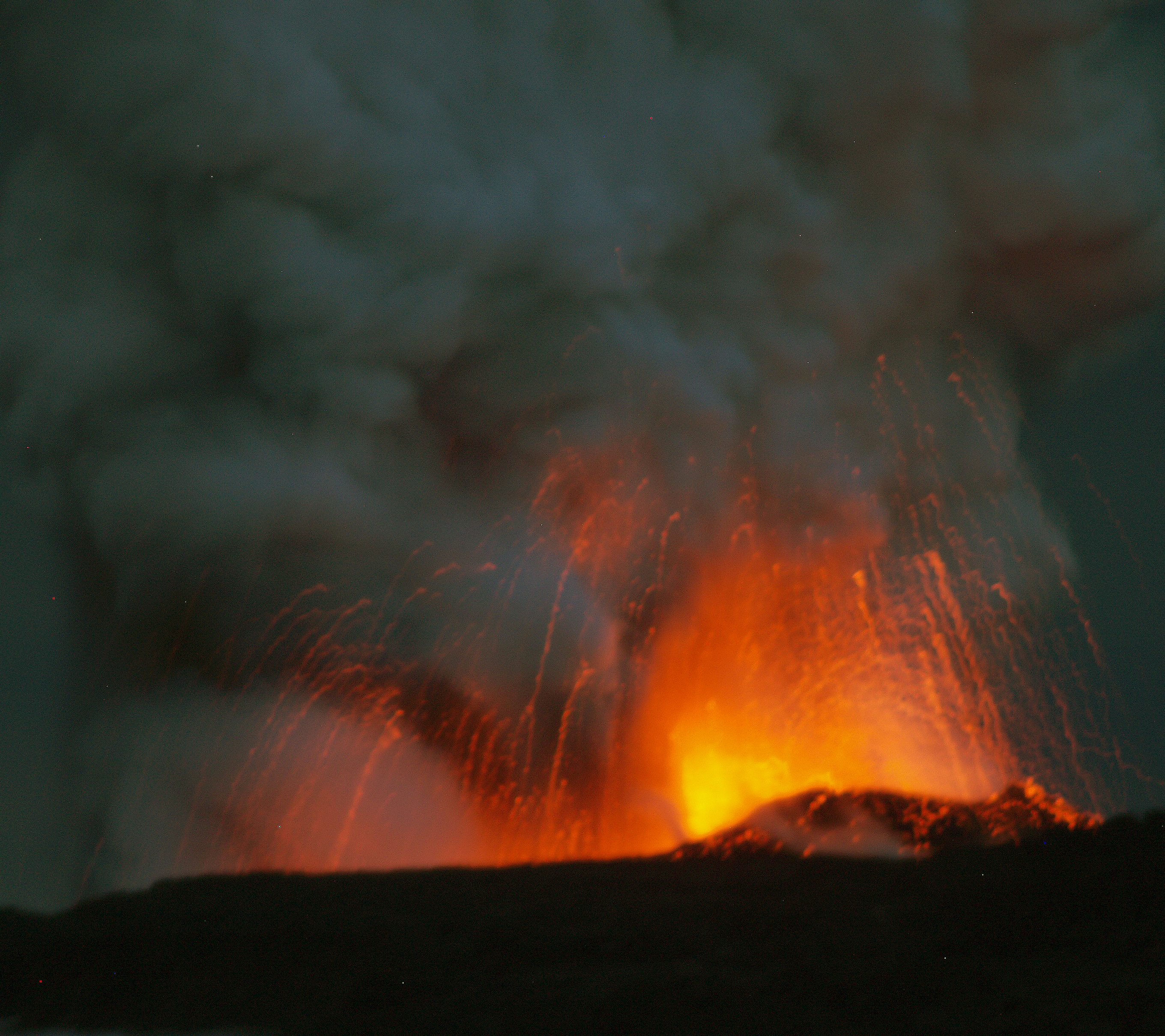
Aloha! I'm Donnie MacGowan, I live on the Big Island of Hawaii where, as luck would have it, we have a number of active and dormant volcanoes. Right now, even as we speak, our Kilauea Volcano, the world's most active volcano, is erupting in two places simultaneously...if you love volcanoes as much as I do, you know that's pretty sweet.
In the past few years I've made several videos of the eruptions from Pu'u O'o and vents further down the Southeast Rift zone, of lava flowing down the pali and entering the ocean, most recently at Waikupanaha. But today I'd like to take you to the other eruption, the one at the summit of Kilauea within the Halema'uma'u crater. It's amazing, captivating, awesome. It's as if the door to the Goddess Pele's home had been left ajar...
Unlike the fountaining littoral explosions down at Waikupanaha, the eruptive vent at the summit of Kilauea Volcano appears quieter but is certainly no less spectacular. Earlier this August when lava stopped flowing into the ocean in Puna, disappointed tourists were dismayed that this eruption might be their only chance of seeing a live volcano, figuring it might be pretty tame and passive. Ho-ho! Come the night time, Madame Pele puts on a show in her own home that is entrancing, beautiful and inspiring. The eruption at Halema'uma'u may be second best to seeing lava flow into the ocean, but it's a very, very close second. If this is the only volcanic eruption you ever get to witness in person, it's a fully awesome, amazingly powerful and spiritual experience. The eruption consists of a huge, roiling plume of gas, steam and ash issuing from hole exploded out of the base of the southeast wall of the crater. The hole and the plume glow wickedly in the dark like the portal to Hades itself.
Earlier in the spring, this vent on Halema'uma'u ejected a great deal of rocks and dust, as if clearing its throat; some bombs and spatter apparently were molten or near-molten at the time of their eruption. Currently, Kilauea is erupting huge amounts of sulfur dioxide and water vapor with very small amounts of ash, prompting the Park Service to close the south part of Kīlauea caldera and Crater Rim Drive to the public and issue occasional air quality alerts for areas adjacent to Hawai`i Volcanoes National Park. Current eruption updates are available by calling the Hawaii Volcanoes National Park Information Hotline at 808.985.6000.
According to recent information from the U.S Geological Survey, the fact that the composition of the gases from Pu`u `Ō `ō and Halema`uma`u appear quite similar may indicate that lava throughout Kīlauea has been recently recharged with new magma from depth.
Further, the USGS suggests that the decrease in hot solid material ejecta concomitant with the steady summit gas emissions may indicate either that magma is receding or that the plumbing and conduits of the vent have become choked off from the surface. This could be due to a mix of rock debris, spatter and ash accumulating in the vent. Molten rock seems to lie just a few hundred feet below the surface of Halema'uma'u crater; however, if the molten rock is in fact retreating, the pool left behind will rapidly cool to a semi-plastic plug.
If the vent plug cools for a substantial amount of time, summit activity will eventually die out and life around Halema'uma'u crater will return to its inter-eruptive, "normal" state. Until the next time fresh, hot magma rises into the volcano, that is.
Man...I could watch this all day, couldn't you?
This is Donnie MacGowan sending you a warm aloha from the slopes of Kilauea Volcano on the Big Island of Hawaii...
For more information about visiting Hawaii in general and touring the Big Island in particular, visit www.tourguidehawaii.com and www.lovingthebigisland.wordpress.com.
Friday, August 8, 2008
Weekly Volcano Update!
Reprinted from here.
For video of the eruptive activity, go here.
Photo By Donnie MacGowan
For video on hiking to see the flowing lava, please go here.
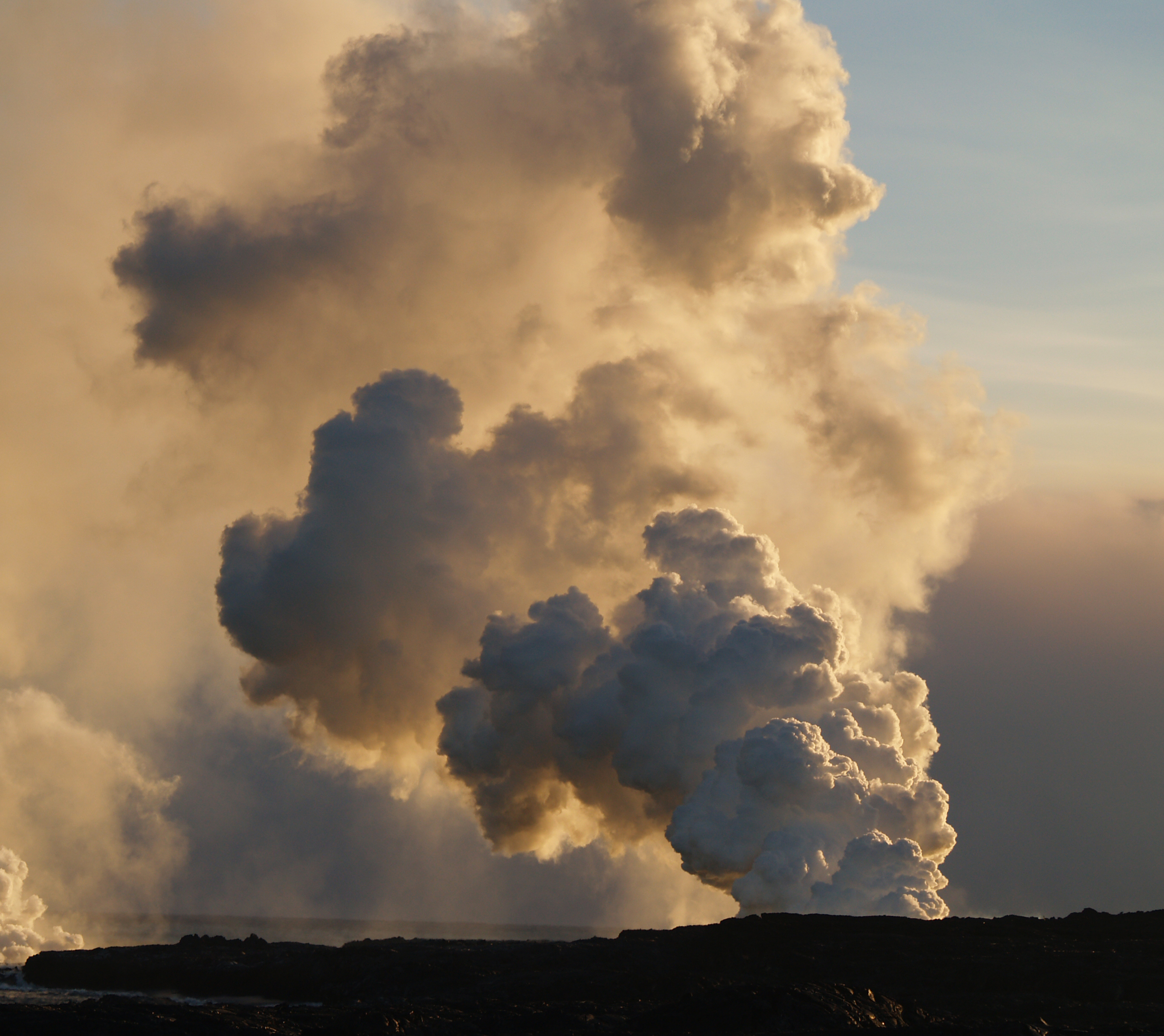
Halema`uma`u appears laid back but . . .
Photo by Dr. Donald B. MacGowan
In contrast to the spectacular incandescent explosions and springtime spatter showers at the Halema`uma`u Overlook in March and April, the eruptive vent at the summit of Kīlauea Volcano seems to have adopted a laid-back summer attitude, with a steady plume rising from a dull glowing hole at the base of the southeast wall of the crater.
The 40-meter-wide (120-feet-wide) opening of this still-fuming chimney provides a partial view into the bright abyss beneath the crater wall that broadcasts the clatter of frequent wall-rock collapses and extends to depths within earshot of splashing and sloshing magma.
During the spring 2008 eruptive period, this hot, gargling vent coughed up an interesting mélange of "pyroclasts" - rocks, dust, and gravel from the collapsed crater floor and conduit walls, mixed with a small portion of bombs, spatter, Pele's hair, and tears that were molten or near-molten when erupted. (The latter fragments are referred to as "juveniles" in volcano parlance because they are first-timers at the earth's surface.)
Pyroclasts can tell us the conditions of their formation. For example, we know that the Pele's hair, tears, pumice, and glassy spatter are identical in composition to the hottest Kīlauea lavas recently erupted along the east rift zone. The composition of the gases from Pu`u `Ō `ō and Halema`uma`u are also similar to each other, showing that, after nearly 25 years of near-continuous volcanic eruption, magma pathways throughout Kīlauea's shallow volcanic edifice are full of new magma from depth.
Subtle clues as to whether the summit eruption will either cease or perhaps become ominously hazardous could be found through further study of the pyroclasts. We have found that a sordid lot of pumice-like glass fragments were, prior to their springtime expulsion from the vent, baked in a fumarole on the sides of the conduit, in a fashion akin to creosote build-up in a stove pipe. Collectively these and similarly recycled material are evidence for subterranean build-up of debris-talus and spatter deposits within the eruption conduit.
Close examination of spatter and large lava droplets (lapilli) reveals dense, relatively cool crystal-mush clots contained within hotter bubbly lava. This is a clear sign that cooler magma was disrupted by hot, effervescing magma prior to eruption.
For the past two months, there has been a scarcity of unquestionably fresh glassy material from Halema`uma`u. The plume is only lightly ash-laden, and newly formed glassy particles that are presently being erupted cannot be readily distinguished from previously erupted material plucked off the ground by strong winds.
Steady summit gas emissions and the small quantity of Pele's hair and tears being erupted indicates that summit magma may have temporarily receded or may no longer be as well-connected to the atmosphere. The Halema`uma`u chimney may be partially sealed by a mix of collapsed wall rocks and choked by recent deposits of lava spatter, pumice, bombs and ash. If magma stops moving within the conduit, it will cool and thicken into a partially molten plug resembling the springtime chunks of relatively cool crystal-mush.
The longer that plug cools, the more likely this recent period of summit activity will slowly come to a close. It is most likely that a balance will persist. A lava plug beneath a subterranean pile of talus and spatter would provide little resistance but plenty of explosion fodder for the next time fresh, hot magma rises beneath the Halema'uma'u Overlook and gas pressure builds up!
Activity update
Kīlauea Volcano continues to be active. A vent in Halema`uma`u Crater is erupting elevated amounts of sulfur dioxide gas and very small amounts of ash. Resulting high concentrations of sulfur dioxide in downwind air have closed the south part of Kīlauea caldera and produced occasional air quality alerts in more distant areas, such as Pahala and communities adjacent to Hawai`i Volcanoes National Park, during kona wind periods.
Pu`u `Ō`ō continues to produce sulfur dioxide at even higher rates than the vent in Halema`uma`u Crater. Trade winds tend to pool these emissions along the West Hawai`i coast. Kona winds blow these emissions into communities to the north, such as Mountain View, Volcano, and Hilo. Incandescence continues to be observed at night inside Pu`u `Ō`ō and suggests minor activity from vents within the crater. There was a small explosion within the crater that deposited small rocks around the east rim of the cone; seismic and tilt data suggest that this occurred on the evening of July 26.
Lava continues to erupt from fissure D of the July 21, 2007, eruption but no breakouts have been observed in the past week on or above the pali. Lava, however, continues to flow through what remains of Royal Gardens and across the coastal plain to the ocean in a well-established lava tube, active now for several months. Minor-to-moderate explosive activity continues at the Waikupanaha ocean entry, and there have been a few new breakouts immediately inland from the delta. A small (2.5 acre) delta collapse that probably occurred between 5 and 6 a.m. on Wednesday, July 30, scattered large rocks up to 100 meters (yards) inland from the collapse scar.
Be aware that lava deltas could collapse at any time, potentially generating large explosions, as happened this past week. This may be especially true during times of rapidly changing lava supply conditions, as have been seen lately. Do not venture onto the lava deltas. Even the intervening beaches are susceptible to large waves generated during delta collapse; avoid these beaches. In addition, steam plumes rising from ocean entries are highly acidic and laced with glass particles. Check Civil Defense Web site (http://www.lavainfo.us) or call 961-8093 for viewing hours.
Mauna Loa is not erupting. Three earthquakes were located beneath the summit this past week. Continuing extension between locations spanning the summit indicates slow inflation of the volcano.
Two earthquakes beneath Hawai`i Island were reported felt within the past week. A magnitude-2.4 earthquake occurred at 00:55 a.m. on Saturday, July 26, 2008, H.s.t., and was located 2 km (1 mile) southwest of Kilauea summit at a depth of 2 km (1 mile). A magnitude-2.7 earthquake occurred at 12:20 p.m. on Monday, July 28, and was located 7 km (4 miles) southeast of Ho`okena at a depth of 14 km (9 miles).
Visit our Web site (http://hvo.wr.usgs.gov) for daily Kīlauea eruption updates, a summary of volcanic events over the past year, and nearly real-time Hawai`i earthquake information. Kīlauea daily update summaries are also available by phone at (808) 967-8862. Questions can be emailed to askHVO@usgs.gov.
For more information on visiting Hawaii in general, or touring the Big Island in particular, please visit www.tourguidehawaii.com and www.lovingthebigisland.wordpress.com.
Wednesday, August 6, 2008
Hiking to the Summit of Mauna Kea, Big Island of Hawaii
Aloha! I'm Donnie MacGowan and I live on the Big Island of Hawaii. Today, I'd like to take you to the top of Mauna Kea. At 13, 796 feet above sea level, Mauna Kea's summit is the highest point in the State of Hawaii; since its base lies at 19000 feet below sea level, its has a base-to-summit height of 33,000 feet, making it the tallest mountain on earth. It's also one of my most favorite places on earth.
Mauna Kea began forming on the sea floor about one million years ago. Its name means "White Mountain" in the Hawaiian language and it is snowcapped much of the winter, and the summit is covered with permafrost 35 feet deep. During the ice ages, Mauna Kea's summit was glaciated 3 times, starting about 200000 years ago and ending only 11000 years ago. One can see the U-shaped valleys and cirques, striated bedrock, glacial tills covering the summit area and remnants of ice-damned lava flows from those times. There are even the remains of extinct rock glaciers near the summit.
The Visitor's Center and summit are reached via a road which turns off Saddle Road at about 6600 feet elevation near the 28 mile marker and tortuously stumbles its way up the south side of Mauna Kea to the Visitor Information Station at about 9300 feet. The road, though steep, is paved to the Visitor's Center. Above that, the road is graded dirt for about 5 miles, returning to asphalt paving for the final sprint to the rim of the summit crater. Road conditions for the summit road are available at 808.935.6263.
The visitor's center is open from 9 a.m. until 10 p.m. 365 days a year. Informational multimedia presentations, souvenirs, and some food items are available here, as well as clean restrooms and drinking water. Every evening after dark the center allows visitors to stargaze through several telescopes and informational talks by visiting scientists are occasionally scheduled. Saturday and Sunday Center staff lead escorted summit field trips, but visitors must provide their own vehicle. Call 808.961.2180 for information. It is suggested that summit-bound visitors stop at the Visitor's Center for at least half an hour before heading to the summit so they can acclimate.
Above the Visitor Information Station there are no public accommodations, no water or food and no gasoline service; the observatory buildings are closed to the public and usually locked. There are neither public telephones nor restrooms, only port-a-potties. An emergency phone is located in the entrance to the U of H 2.2 meter Telescope building.
Driving the summit road to the very top of Mauna Kea is neither as dangerous as the car rental companies want you to believe, nor as casual as many Big Island residents will tell you. True, the summit road is unpaved most of the way, it is steep and winding with limited view planes; the road is extremely hazardous when wet or icy, which is often, and it’s subject to frequent dense clouds, snow, rain and fog obscuring all vision. Also, balmy summer conditions may turn into lethal winter rages in minutes with little or no warning.
However, the road is generously wide, routinely graded and poses no real threat to the cautious driver. The safe driver can expect to reach the summit in about ½ an hour after leaving the Visitor Information Station. Remember, it’s not the roughness of the road that will impede your car; it’s the elevation that will starve it for oxygen. To be safe, take as much time winding your way back down the mountain as you took coming up, using the lowest gear to save wear on brakes. Check your car rental agreement--many forbid you to drive this road. If you go anyway, your insurance is void, and you do so at considerable financial risk. Remember, people DO crater their cars on occasion.
If the weather turns frightful, simply head down immediately. Relax, be calm and drive carefully; you can be confident that, even if you have to slow to 10 miles per hour in places, you'll be down to the safety of the Visitor's Center in a mere 40 minutes or so.
The summit of Mauna Kea, hosting the largest assemblage of astronomical instruments and telescopes in the world, is truly an amazing place; a seductive juxtaposition of icy heights raised up from steaming tropical jungle; the age-old altars of sacred Hawai’ian gods alongside edifices of the most modern of sciences; of frigid landscapes carved during ancient ice-ages alongside fiery volcanic landforms; all wrapped around a fabulous trip with a wee rumor of danger, just for spice! Beautiful, awe-inspiring, 360 degree views of the entire Big Island also include the islands of Maui, Kaho’olawe and Lana’i on clear days. The glow from Kilauea Volcano can be seen on clear nights. Although daytime temperatures during the summer can peak in the 60s, it is generally cold-to-frigid, frequently wet and very windy on the summit. Plan and dress accordingly.
The summit area is also culturally and religiously important to the native Hawai’ians, hosting many religious Heiau, an obsidian adze quarry and numerous other archaeological sites. Remember this landscape, and the archeological sites upon them, are sacred; take nothing but photographs, don't even leave footprints.
Parking is limited, but the hike from the top of the road to the actual summit is a must for any who have ventured this far and are in good shape. A stone altar and a USGS survey point mark the actual summit of the mountain, about a 15 minute walk up a cinder trail from the top of the road. A trail leading around the summit crater takes about 30 minutes to trek and traverses some very wild country with amazing views. Be sure to bring plenty of drinking water and hydrate frequently to help stave off altitude sickness. Do not leave the safety of the parking lot if you are feeling ill or the weather is at all chancy—in fact, in deteriorating or poor weather, or at the onset of queasiness, one should leave the summit immediately and descend.
Alternately, for those in excellent physical condition, one can hike to the summit from the Visitor's center. Featuring unparalleled views, wild landscapes, archeological sites and more, the hike is about 6 miles in length, gains about 4500 feet in elevation and takes 6 to 10 hours to get up, depending on the hiker. There is no water available anywhere above the Visitor's Center, so take enough to get up, and back down. Frankly, many people opt to hitch-hike down the mountain after hiking up. In fact, for folks short on time, or for whom scenery and not summit-conquering are the main goals, catching a ride to the summit and hiking down is a great alterative, and takes only about 3 1/2 hours.
Another absolutely stunning hike in the summit area, one that is accessible to nearly anybody in reasonable condition, is to Lake Wai'au. Park at either the lot at about 12000 feet, near the 5 mile marker, or the lot at about 13000 feet, near the 7 mile marker. Needless to say, one hike is uphill in and the other is uphill out; but both are less than a mile long and have similar elevation changes. I prefer the upper trail because the view of the summit astronomical complex on the hike out is phenomenal. An absolute jewel of an alpine tarn in its own right, at 13,020 feet Lake Wai'au is one of the highest permanent lakes in the world...permafrost seals the lake bed in the loose tephra and glacial drift on which it sits. It's about 300' by 150' by 8 feet deep and, yes, I personally can vouch for its having been snorkeled. Not much to see in there, though.
There are a few health concerns about visiting the summit of Mauna Kea as well. In brief: children under 16, pregnant women, and people with respiratory, heart, or severe overweight conditions are advised not to go higher than the Visitors Information Station. Scuba divers must wait at least 24 hours after their last dive before traveling to the summit.
Acute mountain sickness, resulting from exposure to high altitude, includes nausea, headache, drowsiness, shortness of breath, and poor judgment. Aspirin and lots of water are palliatives for altitude sickness, but the cure is immediate and rapid descent. Sufferers will notice almost complete cessation of symptoms upon regaining The Saddle. Altitude sickness can be dangerous, even life threatening, and rapid onset of comatose condition, or even death, may be unexpectedly swift.
Finally, there is severe risk of serious sunburn and eye damage, particularly when there is snow on the ground. Be sure to wear sunglasses rated to at least 90% IR and 100% UV (both UVA and UVB); wear sunscreen rated to at least SPF 30. Long sleeves and pants help reduce the susceptibility to sunburn.
No trip would be complete without wild life footage; this was the only other living thing on the summit the day I shot this...and just to prove where we are, yup, there's the summit!
Most visits to Mauna Kea's summit are extremely pleasant experiences, encompassing easy adventures which may feature mild altitude euphoria, fabulous views and a great sense of relief at reaching the paved road and public restrooms at the Visitor’s Information Station after leaving the summit.
Well...thanks for spending a little time with me in one of my favorite spots...I've got to run now...this is Donnie MacGowan sending you a hearty "Aloha!"
For more information on visiting Hawaii in general, or touring the Big Island in particular, please visit www.tourguidehawaii.com and www.lovingthebigisland.wordpress.com.
Monday, August 4, 2008
Frank's Travel Hints #8: Mysterious Puna!

Exploring Mysterious Puna...
For your next day of driving, let’s go south on Highway 11 headed for the Puna District. Leave early and expect to get back just after dark because this area is furthest from Kona and contains some of the most beautiful, yet hidden, wonders on the Big Island. It is from Puna that, currently, the only up-close viewing of flowing lava is possible. You may want to pack a cooler for this day trip.
As you’re passing through Kainaliu, just south of Kona, a quick stop at Kona Joe’s Coffee Plantation, for some great Kona Coffee, will jump start your day. See their ad in the sponsors section in your Tour Guide. If you are driving straight to Puna, plan on about 3½ hrs drive time to get to the first sights in this discussion. If you have missed any sights that you wanted to see on the southern route, refer to Frank’s Travel Hints #1 and #2 and catch them on the way...just don't forget to allow for extra time.
Along the way you will pass Hawaii Volcanoes National Park. This is a fascinating place and not to be missed, but we will reserve it for a full day later.
The first turn is about 20 minutes past the park entrance at the town of Kea’au. Look for the stop light on the highway and the Highway 130 sign. The Kea’au Shopping Center has some great places to eat, like Paradise Bar and Grill, and is a good restroom break.
The first stop, in the Puna district, is the town of Pahoa. You will think you have just stepped back into the Wild West as Pahoa has a unique atmosphere like nowhere else on the island. Cute shops, and a great farmer’s market on Sundays, lends to picture taking and shopping. Tour Guide will suggest that parking is easiest at the Community Pool just a block from downtown, and there are public restrooms here.
Continue driving further into Puna on Highway 132 through the lovely tree tunnels to a magical stop at Lava Trees State Park. This gorgeous rainforest park is filled with birds and tropical plants and flowers. What makes this park so intriguing is the lava trees. Tour Guide will tell you how old lava flows surrounded the trees, leaving spires of hardened lava, giving it an eerie look. There are trails for hiking and bird watching is spectacular. This is also a good place for a restroom break as it will be a good while before the next restrooms are available. Highway 132 leads you to Highway 137, the Kapoho-Kalapana Road--the only road in America that is named for two towns buried by a volcano.
Turning toward Kapoho on Highway 137, the next stop is the Kapoho Tide Pools where you can experience great shoreline shell collecting and fantastic snorkeling amongst vibrant corals and tropical fish in protected tidepools. Though hard to find on your own, Tour Guide again knows the way to this secluded sanctuary and ancient village. Port-a-potties and showers are the only facilities here.
Just a few miles down Highway 137 is Ahalanui Hot Pond. This tropical park is centered around a hot spring that mixes with ocean water to create one of the most relaxing and soul recharging oases anywhere. Tour Guide gives you the history of what this area meant to the ancient Hawaiians. Picnicking, hiking, swimming and “expert only” surfing are some of the things to do here. There are restrooms, showers and water available also.
As you continue along the coast road, you will next encounter McKenzie State Park. Here the Ironwood trees create an unusual ambience of a pine tree forest. The sheer cliffs and majesty of the ocean beg for photographing. Swimming would be near impossible here, but the hiking is spectacular. Tour Guide will give more information about this other- worldly park. A permit is required for camping and the facilities are a bit run down.
Not far away is Kahena Beach. This beautiful black sand beach involves a bit of a scamper to get down the cliff, but is well worth the effort. Tour Guide will give you the easiest path to take. You may notice that this beach is “clothing optional”, thus it’s popularity. Swimming here is good, but currents can be strong if you get too far from shore.
Highway 137 used to become the Chain of Craters Road in Hawaii Volcanoes National Park, but it has been cut by several miles of intervening lava flows. Today, it ultimately ends at Highway 130, the road back to Kea'au and the Hawaii Belt Highway. At the intersections of Highways 137 and 130 are the remnants of the town of Kalapana, buried in the 1960 eruption of Kilauea. Tour Guide will tell you all about the eruption, the heroic recovery efforts, and lead you on a brief hike to Kaimu Black Sand Beach, the newest beach on the Island of Hawaii. From the end of the road you can frequently see the both the eruption cloud over Pu'u O'o Vent and the steam plume where lava is entering the ocean, both several miles distant. At night, the glow from streams of lava pouring down the pali can sometimes be seen from here. Although hiking to the lava can be an experience to cherish, it is dangerous and hard work. The best, and most consistent, viewing is by taking an air tour, such as Big Island Air or Paradise Helicopter Tours.
Heading back from Kalapana, you will want to take Highway 130 toward Pahoa and Kea'au, you pass the famous "Painted Church". Tour Guide can tell you the history of this fascinating place. Just a little farther north is the intersection of Highway 130 with the road to Royal Gardens Estates, which currently leads to the Hawaii County-maintained lava viewing area. Call the Lava Hotline at 808.961.8093 for current eruption updates, lava viewing information and times of road openings and closures. Videos of the eruption, as seen from this viewing area, can be seen here, here and here.
As you continue towards Kea'au you will pass the Steam Rooms--a field of steam vents in small craters where locals go to take steam baths. Tour Guide has information on finding these craters and how to safely enjoy the wonders of natural, volcanic steam baths.
Upon returning to the Hawaii Belt Highway at Kea'au, one can proceed in either direction back to Kona, north through Hilo, a bit shorter and faster, or west through Hawaii Volcanoes National Park which, though longer, is much more scenic. If time permits, you may want to stop in Volcano Village, just off the highway, for some food, gasoline, shopping or maybe even some wine tasting. This may be the last gasoline available until you get back to Kona as it is many times hard to find an open gas station in the rural part of Hawaii Island after dark. Find your hotel in your Tour Guide and get turn-by-turn directions right to the door.
For more information on traveling to Hawaii in general and touring the Big island in particular, visit www.tourguidehawaii.com and here.
Saturday, August 2, 2008
The Weather in Paradise!
Reprinted from here.
| ||||||||||
| ||||||||||


Subscribe to:
Posts (Atom)

