Friday, May 9, 2008
Rival Kings, Epic Battles and Ghostly Dogs in Kona, Hawaii
Helani Church/'Ohi'a-Mukumuku Heiau
Those vine covered ruins across the street from St. Peter's are the remains of Helani Church, built by the Rev. John D. Paris in 1861 of basalt block and lime mortar. When the local population moved inland about the turn of the century, a new Helani Church was established mauka (uphill) near the Mamalohoa Highway.
The church, however, was erected on a the grounds of the 'Ohi'a-Mukumuku Heiau; a powerful and holy religious temple around which swirls some of the darkest folklore and ghosts stories told around the Hawai'ian Islands. When you hear ghost stories about a white dog and a black dog, they are about the happenings on the grounds of the 'Ohi'a-Mukumuku and Ke'eku Heiaus, during the time when the Ali'i of Hawai'i, Lonoikamakakahiki, was battling for supremacy with the Ali'i of the Maui, Kamalalawalu, in the 16th century.
Beneath the ruins of Helani Church lie the ruins of 'Ohi'a-Mukumuku Heiau, a place of dark legend and lore. Held in Hawai'ian folktales to have been built by the gods, 'Ohi'a-Mukumuku Heiau was re-dedicated to the war god, Kuka'ilimoku, by the Hawai'i Ali'i Lonoikamakakahiki, so that he might vanquish his foe, the Ali'i of the Maui, Kamalalawalu, during their 16th century battles. It is said of these battles that when the Maui attacked the Hawai'i, the numbers of warriors was so vast that just as the first of the Maui war canoes were landing on Hawai'i, the last of their canoes were still leaving Maui.
Lonoikamakakahiki had a particular disagreement with Kamalalawalu when the invading Maui captured his leading general, had his eyes gouged out and ran spears through the eye sockets. Lonoikamakakahiki vowed a bloody revenge.
When Lonoikamakakahiki vanquished the Chief of the Maui, he took Kamalalawalu over to the nearby Ke'eku Heiau and sacrificed him alive to celebrate his great victory. The method of sacrifice was slow and graphic. Kamalalawalu was staked to the ground for several days, then taken to a nearby flat rock and butchered. The body was then towed to sea and fed to the sharks (some versions of the folktale have Kamalalawalu impaled on a pole for several days before being butchered on the flat rock).
Hawai'ian folktales hold that Kamalalawalu brought with him into battle two large, fierce war dogs, a white one (Kapapako) and a black one (Kauakahiok'oka). The dogs are said to have lain down and died on the spot of Kamalalawalu's execution. Although buried beneath the heiau luakini platform, it is said that these dogs can still be seen roaming, and heard howling, in the night searching the underworld for their fallen master. Two stone features found on the makai side of Ke'eku Heiau stone platform represent the two dogs.
Petroglyphs along the rocks, visible at low tide between Kahalu'u Beach Park and Keauhou O'hana Beach Resort, commemorate the sacrifice of Kamalalawalu by Lonoikamakakahiki.
Produced by Donnie MacGowan.
For more information visit www.tourguidehawaii.com and www.lovingthebigisland.wordpress.com.

Wednesday, May 7, 2008
Playspots of Goddesses and Kings, Kailua Kona, Hawaii
To reach Mo'o Twins Homesite and Punawai Spring, park either in the Kahalu'u Beach Park or at Keauhou Outrigger Beach Resort. From Kahalu'u, walk onto the Keauhou Outrigger Beach Resort property through the gateway in the fence between them and follow the asphalt path to the pool deck, through the lobby of the resort and join the paved path that runs along the end of the Resort driveway. From the Resort parking lot, walk up the drive to the paved path that runs along the end of the driveway. Following along this path, one comes first to the Punawai Spring. Where the path runs around the end of the tennis courts is a lovely little glade enclosed by a tidal pool...this is the homesite of the Legendary Mo'o Twins.
Paokamenehune
The breakwater predates the 15th century temple complexes in the area and is widely said to have been built by the menehune (sort of the Hawai'ian equivalent to leprechauns), but building was actually initiated to enclose the bay as a fishpond. Whether the work became beyond the powers of the Ali'i at the time to administrate or the surfing faction won-out in the battle over use of Kahalu'u Bay is not known, but the breakwater was already in disarray at the time of European contact in the 18th century.To reach Paokamenehune Seawall, park either in the Kahalu'u Beach Park or at Keauhou Outrigger Beach Resort. From Kahalu'u, walk onto the Keauhou Outrigger Beach Resort property through the gateway in the fence between them and follow the asphalt path to the pool deck. From the Resort parking lot, walk up the drive and cross through the lobby to the pool deck. Walk across the tide flat to the water's edge and follow it out to the obvious line of large stones that comprise the seawall. Beware of the rock with is very, very slippery when wet and bear in mind that walking along the seawall is extremely dangerous.
Produced by Donnie MacGowan.
For more information on historic, recreational and interesting places on the Big Island of Hawaii, visit www.tourguidehawaii.com, www.lovingthebigisland.wordpress.com and www.tourguidehawaii.blogspot.com.
Monday, May 5, 2008
Vist the Homes and Temples of Kings, Big Island of Hawaii
Kapua Noni Heiau/Canoe Landing/Ku'ula Stones
Located on a small point of land between just makai of the Keauhou Beach Hotel's pool, is the Kapua Noni Heiau, built by the Ali'i Kalanio'pu'u. This walled enclosure was dedicated to ensuring the abundance of fish. Just north of the Heiau is a canoe landing and the sacred bathing pool, Poho'okapo. Between the canoe landing and the Po'o Hawai'i Pond (King's Pond) are two ku'ula stones. Any stone god, carved or natural, large or small, used to attract fish is referred to as pohaku ku'ula. These two ku'ula are named Kanaio and Ulupalakua and were brought by voyaging canoe from Maui in 1751. Look at the larger stone, the one nearer the plaque, to sea the images of a turtle, a fishhook and shark represented on it, using a combination of the natural lines of the stone and engraving. The round hole near the top indicates that this was also a "luakini" stone, or stone for human sacrifice. A loop of rope was passed through the hole, around the victim's neck, and tightened until strangulation was complete. It is not known if human sacrifice at this stone was used as punishment, to propitiate the gods for good fishing, to dispatch enemy combatants for ritual cannibalism, or some combination of these.
To reach the Ku'ula Stones, Heiau and Canoe Landing, park either in the Kahalu'u Beach Park or at Keauhou Ohana Beach Resort. From Kahalu'u walk onto the Keauhou Ohana Beach Resort property through the gateway in the fence between them, and onto the paved path toward the pool deck. From the Resort parking lot, walk up the drive and cross through the lobby to the pool deck. Kapua Noni Heiau is the raised stone platform directly seaward of the pool deck, and is marked by carved wooden. The canoe landing is along the rock-free shoreline directly seaward and to the north of the Heiau. The ku'ula stones are prominent standing stones along the paved path in the garden between the hotel and the Kalanikai Bar and Grill. The Ku'ula Stones and Kapua Noni Heiau are marked by historical information plaques. Remember that these are holy religious sites to modern native Hawai'ians; to not trespass, walk or climb on the temple proper; take nothing but photographs, leave nothing but footprints.
Produced by Donald B. MacGowan.
For more information on exploring Hawaii and unlocking its hidden secrets, visit www.tourguidehawaii.com and www.lovingthebigisland.wordpress.com.
Located on a small point of land between just makai of the Keauhou Beach Hotel's pool, is the Kapua Noni Heiau, built by the Ali'i Kalanio'pu'u. This walled enclosure was dedicated to ensuring the abundance of fish. Just north of the Heiau is a canoe landing and the sacred bathing pool, Poho'okapo. Between the canoe landing and the Po'o Hawai'i Pond (King's Pond) are two ku'ula stones. Any stone god, carved or natural, large or small, used to attract fish is referred to as pohaku ku'ula. These two ku'ula are named Kanaio and Ulupalakua and were brought by voyaging canoe from Maui in 1751. Look at the larger stone, the one nearer the plaque, to sea the images of a turtle, a fishhook and shark represented on it, using a combination of the natural lines of the stone and engraving. The round hole near the top indicates that this was also a "luakini" stone, or stone for human sacrifice. A loop of rope was passed through the hole, around the victim's neck, and tightened until strangulation was complete. It is not known if human sacrifice at this stone was used as punishment, to propitiate the gods for good fishing, to dispatch enemy combatants for ritual cannibalism, or some combination of these.
To reach the Ku'ula Stones, Heiau and Canoe Landing, park either in the Kahalu'u Beach Park or at Keauhou Ohana Beach Resort. From Kahalu'u walk onto the Keauhou Ohana Beach Resort property through the gateway in the fence between them, and onto the paved path toward the pool deck. From the Resort parking lot, walk up the drive and cross through the lobby to the pool deck. Kapua Noni Heiau is the raised stone platform directly seaward of the pool deck, and is marked by carved wooden. The canoe landing is along the rock-free shoreline directly seaward and to the north of the Heiau. The ku'ula stones are prominent standing stones along the paved path in the garden between the hotel and the Kalanikai Bar and Grill. The Ku'ula Stones and Kapua Noni Heiau are marked by historical information plaques. Remember that these are holy religious sites to modern native Hawai'ians; to not trespass, walk or climb on the temple proper; take nothing but photographs, leave nothing but footprints.
Produced by Donald B. MacGowan.
For more information on exploring Hawaii and unlocking its hidden secrets, visit www.tourguidehawaii.com and www.lovingthebigisland.wordpress.com.
Sunday, May 4, 2008
Tour Guide Hawaii Presents: Hawaii's Sky Tonight
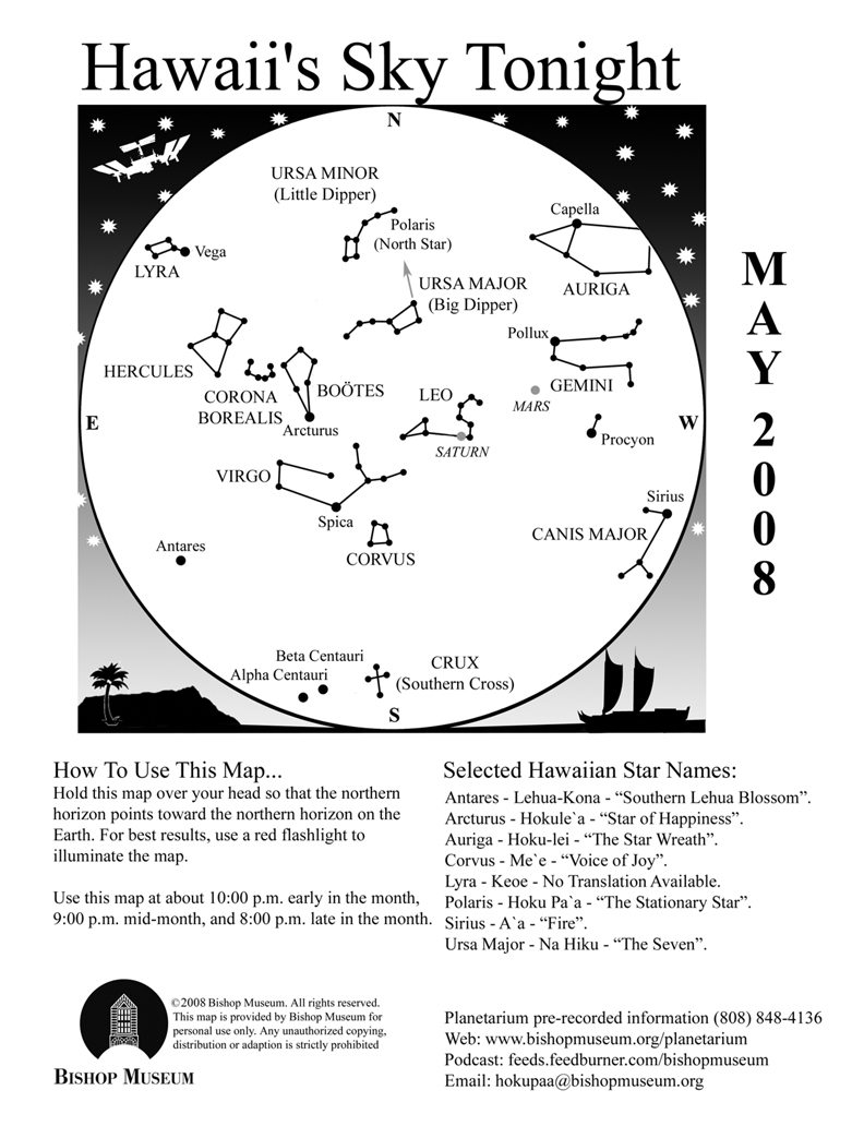
From The Bishop's Museum "Skywatch" webpage.
ETA AQUARIDS AND SMALLEST FULL MOON
We spent last month being “grounded” by the myriad of science events in town and I didn’t spend much time on things going on above our atmosphere. In contrast, this month is a bit busier with interesting sky-watching events as well as a number of human-generated activities in our solar system.
Starting with the natural events in our sky, May has the second of the two “really good” meteor showers of the year, with the best-coinciding Moon phase to look for meteors. The Moon is “new”, or dark during the shower, which means there is no moonlight to compete with the streaking lights, however staying away from city lights will make for even better seeing conditions. The Eta Aquarids will peak at 8:00 A.M. on May 5. The radiant of the shower rises in the constellation Aquarius almost directly due east by 2:30 A.M. on May 5, so between then and sunrise is the most ideal viewing time. The Eta Aquarids are leftover bits of Comet Halley making contact with our atmosphere. Often characterized as “dirty snowballs”, comets are essentially loosely packed material that “shed” as they travel through space, especially as they get warmed by the sun. This debris is often pieces no larger than pebbles or dust. Please note that because Aquarius will not rise until the early morning hours, it will not be included on this map. But don’t worry, you do not need a star map nor knowledge of the constellation to look for the Eta Aquarids if you go by the times and direction to look (east).
Speaking of the Moon, this month’s full Moon is the smallest of 2008. Remember that the Moon’s orbit is not perfectly circular but elliptical so there is a closest and farthest point to the Earth every month, called perigee and apogee, respectively. This month’s full Moon coincides with its apogee, therefore making it appear smaller in the sky. The difference visually is less than 10% and most people will probably not notice it, but pictures of the Moon compared at both extremes (perigee and apogee) will definitely show the difference. A good website for this is Astronomy Picture of the Day and search for “apogee” or “perigee”.
SPACE TRAFFIC
There are a lot of exciting missions heading off into space this month—starting closest to the Earth, the space shuttle Discovery is scheduled to launch the last day of May to the International Space Station (ISS). The shuttle carries more components for the Japanese laboratory KIBO and an astronaut from the Japan Aerospace Exploration Agency (JAXA) as a mission specialist. KIBO, which means “hope” in Japanese, will join the recently-added European Space Agency’s Columbus Lab and the existing research modules from the United States and Russia.
Moving further out into the solar system, NASA is anxiously waiting for May 25, when the newest Mars explorer touches down on the Red Planet. The Phoenix Mars Lander has been cruising the 422 million miles to the planet since it launched last August and will join the two Mars rovers, Spirit and Opportunity on the surface in the search for water and signs of habitability. While the rovers explore the equatorial region of Mars, Phoenix will be located at the north polar area. In comparison, if Phoenix were on Earth it would be in Northern Canada within the Arctic Circle. Water is the main ingredient for supporting life as we know it, and scientists are concentrating on this part of Mars because there is evidence of large amounts of water locked in the ice caps at the poles.
Phoenix is named after the mythical bird that bursts into flames as it dies, bringing forth a new bird from its ashes. The Phoenix Mars Lander carries instruments and spacecraft design from two unsuccessful missions, the Mars Polar Lander and the Mars Surveyor 2001 Lander, reviving the technology and making this mission the first to explore the icy polar region of the planet from the surface.
Lastly, a mission that will explore the farthest ends of the universe is also scheduled to launch in mid-May. NASA’s Gamma-Ray Large Area Space Telescope (GLAST) will search deep space for gamma-ray bursts, one of the most elusive and the most powerful forms of radiation in the universe. It is not known what causes these massive explosions of energy and scientists are hoping to determine whether exotic objects such as black holes or neutron stars are involved. GLAST will also study other sources of high-energy, like supernovas and pulsars, to help give more insight to our understanding of the universe.
The Planets
Earth:
Lahaina Noon season begins. Between May and July the sun passes directly overhead for areas within the Tropics. During Lahaina Noon objects that are directly perpendicular to the sun, such as flagpoles or fences, have no shadows since the “shadow” would be cast right “under” the object. Times vary by location, so check the website for more information: www.bishopmuseum.org/planetarium
Mercury:
Mercury is back in the western sky at sunset, low in the horizon during the first week of May and getting to its full height at mid-month. Although small, Mercury is fairly bright but is typically visible mostly during twilight because by the time the sky is fully dark the little planet is too low to the horizon for most people to see. (Unless you have a clear view to the west)
Venus:
Unfortunately the brightest planet is no match for the brightest star in our sky. Venus is very close to the sun right now and will move behind it next month. The casual observer will have a difficult time spotting it the few minutes before the sun rises in the first week of the month.
Mars:
Mars moves from Gemini into Cancer during this month and towards the end of the month (May 21-23) and passes through a nice binocular cluster, M44 or the Beehive Cluster. During the first couple of weeks while the planet is still in Gemini, however, look for the fading planet next to the two brothers’ “heads” at the east of the constellation. It is still as bright as Pollux (the more eastern twin) but continues to fade as it recedes from Earth. On May 9 a crescent Moon joins the group as Mars makes its way eastward. The constellation Cancer contains few bright stars discernable from the city, so it is not included on the map, but follow Mars’ path through the month and see if you can spot the cluster of hundreds of stars with binoculars during its trek through the Beehive!
Jupiter:
Jupiter rises right around midnight the first few days of the month and almost half an hour earlier by just the first week. By the end of the month the giant planet will rise by 10:00 P.M. Jupiter is to the east of the “teapot handle” of Sagittarius, but you won’t have any trouble finding it in the sky because of its brightness.
Saturn:
At the start of May Saturn is almost at zenith at nightfall and next to the “heart” of the constellation Leo. If you are looking at Mars during the month with binoculars, don’t pass up the chance to spot Saturn while you’re at it since they are in the same part of the sky.
To see video of exploring the lava flow, go here and here; for more information on exploring the Big Island, go here and here; for information on renting GPS-guided tours of the Big Island, go here to see a video demonstration of GPS-guided tours of the Big Island, go here.

Saturday, May 3, 2008
Kilauea; Weekly Volcano Watch from the U.S. Geological Survey
Professor Jaggar would have loved this view
From the USGS Volcano Watch Site, published April 24, 2008.  | |
| Gas geochemist Jeff Sutton does a duty shift in the HVO tower keeping an eye on the Halema`uma`u vent. | |
Unusual, tantalizing, mesmerizing. Adrenaline-spiking, mid-life crisis(?). These words have been used in our recent Volcano Watch reports as we present our observations and describe Kilauea Volcano's behaviors related to and following the explosion that occurred at Halema`uma`u on March 19. The event has definitely been unique in our modern era of volcano watching.
It is important to recognize that the recent explosions on March 19, April 9, and April 16 are all quite small, compared to Halema`uma`u's previous explosive sequence in 1924. We also need to understand that Halema`uma`u prior to 1924 was quite different from now, as it then contained an active lava lake.
At the same time, what we are experiencing is exactly why Thomas Jaggar established HVO at Kilauea in 1912.
The offices and labs of the U S Geological Survey's Hawaiian Volcano Observatory - modernized in 1987 and named the Reginald T Okamura Building in 2002 - are perched at cliff's edge, overlooking Kilauea's summit caldera with a view into Halema`uma`u.
Perhaps the most recognized feature of the Okamura Building is its tower providing a 360° view around HVO. Interestingly, the current Halema`uma`u activity is the first opportunity to observe and study an eruption from the tower since it was built,. Since March 19, HVO staff have maintained a round-the-clock caldera watch to observe and record changes occurring in Halema`uma`u. Visiting scientists Wendy McCausland, Mike Doukas, and Dan Dzurisin (former HVO staffer) from the USGS's Cascades Volcano Observatory have provided crucial support by coming to HVO and manning the tower through the long midnight shift.
Time-lapse and video cameras have been mounted in the tower to record any visible changes at the vent. Images from the webcam are available on HVO's public website at http://hvo.wr.usgs.gov/cam3/ along with Kilauea eruption updates at http://volcano.wr.usgs.gov/kilaueastatus.php . The most fun piece of equipment is a tripod-mounted, 2-foot-long pair of binoculars.
Also set up in the tower since March 19 is a computer with network access to all of HVO's monitoring data streams. Displays of photographic, gas, geodetic, seismic, and thermal data are only a few mouse clicks and keystrokes away. Besides the obvious convenience, being able to look at diverse data on a single computer terminal - instead of running different programs on a number of different computers - affords the opportunity to develop more integrated and timely volcanological interpretations.
None of the above should be read to imply that HVO is simply looking at data that are automatically collected and piped into our computers. Important keys to eventually understanding what happened on March 19, as well as what we might reasonably expect to follow at Halema`uma`u, come from field sampling of both the gaseous and the solid emissions spewed from the vent.
Car traverses in the caldera are driven at least once per day when winds allow measurement of the gas composition of the Halema`uma`u plume. Also, once per day, ash and lava samples are carefully and systematically retrieved from numerous ash collectors placed on the caldera floor. Assessments of both the amount and compositions of these samples provide insights into what lies beneath the caldera and why Kilauea is behaving as we observe.
While HVO's monitoring networks are already dense around Halema`uma`u, HVO scientists have deployed additional instruments to complement the permanent instrumentation. A continuously operating gravimeter is recording signals that might reflect increases or decreases in the magma mass stored beneath Kilauea caldera, and additional GPS receivers near Halema`uma`u are intended to improve resolution of smaller-scale ground surface movements around the vent. Groups of borrowed portable seismometers were temporarily deployed in small antenna-like arrays to help locate ultra-small earthquakes beneath the new vent.
As Halema`uma`u continues to entertain and intrigue, we maintain our enhanced observing. With contingency and continuity-of-operations plans in place, we expect that if Halema`uma`u should explode more violently; we will be doing much of the same - only not so close to ground-zero. Please continue to share our web postings at: http://hvo.wr.usgs.gov.
Activity update
Kilauea summit and Pu`u `O`o continued to deflate after completing two DI tilt events this past week. Sulfur dioxide emission rates and seismic tremor levels have remained elevated at several times background levels. Earthquakes were located primarily beneath Halema`uma`u Crater and the adjacent areas, the southwest rift zone, and the south flank faults.
Lava from the 2007 Thanksgiving Eve Breakout (TEB) flow, erupting from fissure D of the July 21 eruption, continues to flow through what remains of the Royal Gardens subdivision and across the coastal plain. On Wednesday, March 5, the flow entered the ocean (Waikupanaha entry) in the vicinity of Kapa`ahu. The Waikupanaha delta has since grown to a width of about 1,000 m (3,280 ft) and has multiple entry points. On March 15, another branch of the flow reached the ocean (Ki entry) farther to the east, within a few hundred meters of the lava viewing area. During the past week, lava supply to the Ki entry ceased, though the Waikupanaha entries remain fully active.
The public should be aware that the ocean entry areas could collapse at any time, potentially generating large explosions in the process. The steam clouds rising from the entry areas are highly acidic and laced with glass particles. Do not venture onto the lava deltas. Even the intervening beaches are susceptible to large waves suddenly generated during delta collapse; these beaches should be avoided. Check the County of Hawai`i Civil Defense website (http://www.lavainfo.us) for information on public access to the coastal plain and ocean entry.
The surface flows active last week on TEB shield complex were stalled by Saturday, April 19, and no other surface flows in the shield complex area have been observed this week. Throughout the past week small breakouts from the tube system have been observed in the Royal Gardens subdivision.
No incandescence was observed at night in Pu`u `O`o in the past week, though minor incandescence has been sporadically present throughout the past few months. As in years past, Pu`u `O`o likely is serving as a large chimney, beneath which lava is briefly stored and substantially degassed on its way to the eruption site.
On March 11, a new fumarole appeared low on the southeast wall of Halema`uma`u Crater, within Kilauea's summit caldera. The new vent is located directly beneath the Halema`uma`u Overlook about 70 m (230 ft) down. At 2:58 a.m. on March 19, a small explosion occurred from this fumarole. The explosion scattered rock debris over an area of about 75 acres, covering a narrow section of Crater Rim Drive, the entire Halema`uma`u parking area, and the trail leading to the overlook. The overlook was damaged by rocks that reached up to 90 cm (3 ft) across. No lava was erupted as part of the explosion, suggesting that the activity was driven by hydrothermal or gas sources. On April 9 another small explosion occurred, depositing dense blocks and particles of fresh lava on the overlook area. Last week, another small explosion from the vent occurred at 3:57am on April 16, producing a dusting of pale-red ash west of the crater. The new explosion pit continues to vigorously vent gas and ash, with the plume alternating between brown (ash-rich) and white (ash-poor). Fresh lava spatter, Pele's tears and Pele's hair have been collected at the rim, indicating that magma resides at shallow depths in the new conduit.
Sulfur dioxide (SO2) emission rates from the summit area have been substantially elevated up to 10 times background values since early January; the emission rates for the past week have been decreasing but are still elevated. The increase in sulfur dioxide emission rates at the summit means that SO2 concentrations are much more likely to be at hazardous levels for visitor areas downwind of Halema`uma`u, especially during weak wind conditions or when winds blow from the south. Most people are sensitive to sulfur dioxide at these levels, especially children, individuals with asthma, chronic obstructive pulmonary disease (COPD), or other breathing problems. Stay informed about SO2 concentrations in continuously monitored areas (Jaggar Museum and Kilauea Visitor Center) by visiting the Kilauea Visitor Center and the web at:
http://www2.nature.nps.gov/air/webcams/parks/havoso2alert/havoalert.cfm. To minimize these potentially harmful effects, Hawai`i Volcanoes National Park has closed all access to the southern half of Kilauea caldera.
One earthquake beneath Hawai`i Island was reported felt within the past week. A magnitude-3.3 earthquake occurred at 7:08 p.m., and was located 10 km (6 miles) northwest of Pahala at a depth of 10 km (6 mile).
Mauna Loa is not erupting. One earthquake was located beneath the summit. Extension between locations spanning the summit, indicating inflation, has resumed following a few months of stagnation.
Visit our Web site (http://hvo.wr.usgs.gov) for daily Kilauea eruption updates and nearly real-time Hawai`i earthquake information. Kilauea daily update summaries are also available by phone at (808) 967-8862.
To see video of exploring the lava flow, go here and here; for more information on exploring the Big Island, go here and here; for information on renting GPS-guided tours of the Big Island, go here to see a video demonstration of GPS-guided tours of the Big Island, go here.
Friday, May 2, 2008
Frank's Hawaii Travel Tips #9: Made for Adventure: The Jungles, Volcanoes, Hot Springs and Tidepools of Puna!

Deeper into mysterious Puna!
As you continue along the coast road, you will next encounter
Not far away is
Drive just a few miles further and you come to what used to be the town of
What remain are a few homes and businesses where the road now ends. From here one can see the plume of smoke coming from the vent upslope. Sometimes the lava reaches the ocean about 2 miles from this spot.
A short five minute hike will bring you to
Heading back from Kalapana, you will want to take Highway 130 toward Pahoa. This is your best chance of watching Kilauea erupt. Just a few hundred yards north of Kalapana, is the old turn off to Royal Gardens. This is now the official County of Hawaii Lava Viewing Site. Drive as far as the attendants will allow you, park and walk into where you can safely view the lava flowing into the ocean. Daily updates on the volcano and conditions at site are available at the Hawaii County Lava Viewing Desk, phone number 808.961.8093; more information is here and here.
Farther along the highway to Pahoa, you will see a “scenic turnout” where you can view the Puna Geothermal Vents. Here a company has tapped the natural steam to create electricity from these fumaroles. Tour Guide will show you how, with a short hike off the road, and you can sit in one of these natural sauna vents for some real relaxation.
Now you’re ready to head back to Kona. Take Highway 130 to Highway 11 and go south. If time permits, you may want to stop in
Frank's Big Island Travel Hints #12: More fun in Hawaii Volcanoes National Park, Big Island, Hawaii
 Deeper and Deeper into Hawaii Volcanoes National Park
As you continue driving around and exploring
One of the best day hikes in the park is the Kilauea Iki Crater Trail. This four mile round trip hike, about three hours at a nominal pace, will descend into the crater itself. From the floor of the crater, you will see fern, Ohia, and tropical rainforest crowding right up to the rim. The floor itself is stark desert, by comparison, as the trail takes you across and then up the other side. Make sure to bring plenty of water and maybe even some snacks for this hike.
To see even more of the parks wonders, we at Tour Guide suggest a drive down the Chain of Craters Road. This drive unlocks dozens more sights, hikes and vistas from high mountain rainforest to the barren lava landscapes and scenic ocean views below. Along this road are a number of overlooks for some fabulous photography. It ends at the sea where waves crash and spew against cliffs with steam clouds in the distance where lava reaches the ocean. Let’s see what this stunning area has to offer.
Lua Manu is a pit crater formed before written records were kept of the eruptive activity in the park. You will notice no cinder around the rim. This indicates no eruption here but a lava lake that formed inside the pit. As it drained, the pit collapsed, the latest of which was in 1974.
There are several more pit craters to see along this route and then you will come to
Back on Chain of Craters Road, Tour Guide brings you to Puahi Crater, a large hourglass shaped crater that has held lava from many different flows over the years. Most recently, the 1979 earthquakes opened the south rift of the crater and issued steam and lava fountains. Though this episode only lasted one day, it was precursor to the current flows from Pu’u O’o in 1983 that destroyed hundreds of homes and businesses miles away in the Puna District.
Tour Guide will guide you to Kipuka Kahali’i. A kipuka is a hole or space where the lava surrounded forest or grassland but did not burn it. This one was partially devastated by the 1969 hot ash eruption of Mauna Ulu. The tallest trees survived and some hearty species of plants have returned.
Subscribe to:
Posts (Atom)

