| ||||||||||
| ||||||||||
Friday, June 13, 2008
This Week's Weather In Paradise!





Wednesday, June 11, 2008
Franks Big Island Travel Hints #2: South Kona to Ka'u
 Frank's Big Island Travel Hints:
 Driving south on Hwy 11 there isn’t too much to stop and see for several miles, so enjoy the panoramic views. Soon your Tour Guide will give you information about Ho’okena Beach and Milolii.
Ho’okena is a lovely gray sand beach about 5 miles off the main hwy. This is a nice beach for swimming, snorkeling and picnicking. There are some trails to hike and decent restrooms. Camping is also available by permit only. Your Tour Guide will give more information about trails to hike, camping, and where to get snorkel gear and camping permits.
Driving a few miles further, headed toward the volcano park, is the turn off for Milolii. Again about 5 miles off the main highway, Milolii is one of the last fishing villages in
As with anywhere you travel, make sure to lock your vehicle when you leave it and don’t leave valuables in plain sight.
Tour Guide will show many other great places to explore as you continue driving south. We’ll jump ahead at this point to the southernmost town in the
Driving about 10 miles further south, your Tour Guide will recommend the Punalu’u Black Sand Beach, one of the top 44 sites on the
Driving south from Punalu’u Black Sand Beach, you will notice the highway begin to ascend toward the
Monday, June 9, 2008
www.tourguidehawaii.com presents: 'Ahu'ena Heiau...Temple of War Gods, Temple of Gods of Plenty
Written directed and produced by Donald B. MacGowan; Narrated by Frank Burgess; Original Musical Score by Donald B. MacGowan.
Ancient ruins? Human sacrifice?
If you are the kind of person who enjoys the excitement of archeology, then this next spot on your tour around the island maybe just what you are looking for. Centuries ago the inhabitants of this region built a series of sacred temples, or heiaus, which were originally used for the purpose of sacrificing human beings to their war god, Kuka'ilimoku. This particular archeological site is called Ahu'ena Heiau, which in Hawaiian means "Hill of Fire".
Take a moment to stop here for a look, who knows what you may find. Who knows what spirits you my encounter. In any event, as you take the time to examine the reconstructed grounds of this particular heiau, keep in mind that to this very day these are places of sanctity and solace for many of the native Hawai'ians. As with all such places, remember to respect this setting as well by not removing anything whatsoever from the site. Meanwhile, as you ponder in your minds just what it is you're looking at, consider a little history...
More information on visiting Hawaii on general and touring the Big Island in particular, including in-depth information on the history, religion, archeology of the Polynesian peoples, go here and here.
Ancient ruins? Human sacrifice?
If you are the kind of person who enjoys the excitement of archeology, then this next spot on your tour around the island maybe just what you are looking for. Centuries ago the inhabitants of this region built a series of sacred temples, or heiaus, which were originally used for the purpose of sacrificing human beings to their war god, Kuka'ilimoku. This particular archeological site is called Ahu'ena Heiau, which in Hawaiian means "Hill of Fire".
Take a moment to stop here for a look, who knows what you may find. Who knows what spirits you my encounter. In any event, as you take the time to examine the reconstructed grounds of this particular heiau, keep in mind that to this very day these are places of sanctity and solace for many of the native Hawai'ians. As with all such places, remember to respect this setting as well by not removing anything whatsoever from the site. Meanwhile, as you ponder in your minds just what it is you're looking at, consider a little history...
More information on visiting Hawaii on general and touring the Big Island in particular, including in-depth information on the history, religion, archeology of the Polynesian peoples, go here and here.
Saturday, June 7, 2008
Tour Guide Presents: Akaka Falls, Big Island, Hawaii
There is a reason that Akaka Falls rates as the most visited tourist sites on the island of Hawai'i. Simply put, the 420 foot, free falling plunge of clear water down a fern festooned cliff is an amazing and beautiful site. Leaving the parking lot, the loop trail immediately splits. Going left through fern, ginger, impatiens and bamboo, one reaches Akaka Falls in 5-8 minutes of ambling. If you turn right, the trail loops up and down some hills, through a wonderful jungle of flowers, ferns, heliconia, palms and bamboo to 100 foot tall Kahuna Falls in about 15 minutes of walking; Akaka Falls is then reached by following the same path another 5 minutes and 5-8 minutes after that you are back at the parking lot.
Almost every town in Hawai'i has a "Wainuenue street". From the Hawai'ian syllables "wai" meaning "fresh water" and "nue" meaning "colorful" or "dancing", the word "wainuenue" refers to the rainbow seen in waterfalls. If you are lucky, and approach Akaka Falls on a sunny morning when the sun shines into to grotto, you may be blessed with seeing this lovely Hawai'ian icon, the wainuenue.
When visiting Akaka Falls, be sure to save some time to explore the shops, galleries and cafes of Honomu on the way back to the highway; it's unlike anywhere you've ever been before...guaranteed.
For further information, visit www.tourguidehawaii.com and www.lovingthebigisland.wordpress.com.
Thursday, June 5, 2008
Weekly Volcano Watch
Reprinted from: http://hvo.wr.usgs.gov/volcanowatch/
Kilauea Eruption StatusLava from the 2007 Thanksgiving Eve Breakout (TEB) flow, erupting from fissure D of the July 21 eruption, continues to flow through what remains of the Royal Gardens subdivision and across the coastal plain to the ocean within well-established lava tubes. Over the past week, the Waikupanaha ocean entry has produced vigorous small explosions, with ejecta fallout limited to the new delta.
The public should be aware that lava deltas could collapse at any time, potentially generating large explosions in the process. This may be especially true during times of rapidly changing lava supply conditions, as have been seen lately. Do not venture onto the lava deltas. Even the intervening beaches are susceptible to large waves that are suddenly generated during delta collapse; these beaches should be avoided. In addition, the steam plumes rising from the ocean entries are highly acidic and laced with glass particles. Check the County of Hawai`i Civil Defense website (http://www.lavainfo.us) or call 961-8903 for information on public access to the coastal plain and ocean entry.
Mauna Loa is not erupting. One earthquake was located beneath the summit. Extension between locations spanning the summit, indicating inflation, has resumed following a period of stagnation.
No earthquakes beneath Hawai`i Island were reported felt within the past week.
Visit our Web site for daily Kilauea eruption updates and nearly real-time Hawai`i earthquake information. Kilauea daily update summaries are also available by phone at (808) 967-8862. Questions can be emailed to ask HVO@usgs.gov.
For videos about the Kilaeua eruption, go here and here; for more information about visiting Hawaii in general and touring the Big Island in particular, go here and here.
Tuesday, June 3, 2008
Frank's Travel Around Hawaii Tip #1
 Aloha is a Hawaiian word for hello, goodbye and a word they use for love. In the literal translation, “alo” is life and “ha” is breath. So when you say “Aloha”, and someone returns the greeting, you are sharing the breath of life.
 The Big Island of Hawaii is the largest land mass in the state. I fact, all the other Hawaiian islands will fit inside the Big Island and only take up about half of it.
Therefore realize it takes 6-7 hours to drive around this island, if you don’t stop anywhere. I always suggest if you are going to drive and see the sights yourself, split the driving into 3 days and pick up your GPS Tour Guide (808-557-0051).
The first drive day, go to the
I wear shorts, tee shirt and comfortable walking shoes. BUT, also bring my sweat pants and sweatshirt. At 4200 ft. elevation, temperatures can vary from 80 to 45 degrees and weather conditions can change in a matter of minutes, so BE PREPARED. My advice is leave early (7:AM) and expect to get back about dark (6-7 PM). Tour Guide will get you there and back safely and has all the info about hiking, biking, museums and much more.
There are a number of great sights between Kona and the volcano that could be a whole day of sight seeing, all found in your Tour Guide.
When leaving Kona going south, you will enter the coffee country. There are several farms that offer free coffee sampling and tours. Just look for the signs along the highway. Kona Joe’s (visit here and see video) is one of my favorites. They grow their coffee on trellises like fine wine in
Continuing south, brings you to the turn off for
Stay along the coast headed south, on the single lane road for 4 miles, and you will arrive at Pu'uhonua O Honaunau National Historic Park, also known as the “Place of Refuge”. Tour Guide help will make this magical spot come alive; for even more information, visit here.
Sunday, June 1, 2008
Hawaii's Sky Tonight!
This article reprinted from http://www.astroday.net/bishopsky.html
SKY GEOMETRY
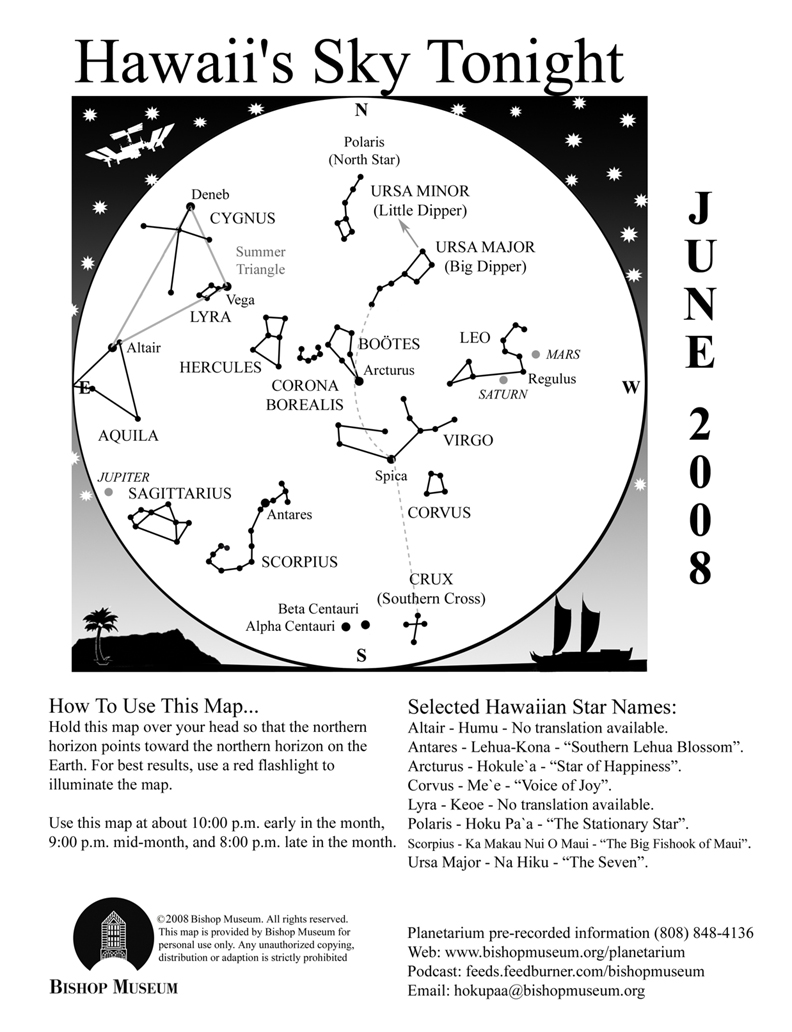
The patterns we see in the sky exist only in our imagination. The points of light we group to create the shapes we call constellations are arbitrary and usually don’t have any connection with each other at all except that they happened to line up in someone’s mind at one time. The 88 “official” constellations are recognized by a group of professionals called the International Astronomical Union to help keep order and structure to the science of astronomy. Otherwise, imagine what chaos might reign—how would anyone know how to distinguish one part of the sky from another if names were random? For instance, the constellation Crater the Cup in the southern sky next to Corvus looks remarkably like my Weber grill, but I can’t very well start referring to it as such. As it is, we sometimes “shorten” the constellations anyway. Sagittarius is often referred to as the Teapot, and part of the Big and Little Bears are called the Big and Little Dippers, respectively.
Informal groupings or segments of constellations are called asterisms. They are usually parts of constellations that are more easily recognized, like the Dippers and the Teapot, and at times the references are updated. Some constellations are simply easier to recognize by these nicknames. I have heard the constellation Boötes the Herdsman referred to as a “bowtie” or “ice cream cone”, which most people relate to better.
Sometimes asterisms include groups of stars or constellations, like the Summer Triangle. Known anecdotally as a basic element of celestial navigation, the Summer Triangle is comprised of the three brightest stars in three separate constellations forming a large, distinctly triangular shape in the sky. First to rise in the east is the star Vega in the constellation Lyra the Lyre. Lyra is a small constellation that takes a bit of effort to imagine the harp-shaped instrument from the parallelogram of stars, but it is an area rich in telescopic sights. One is the famous Ring Nebula, M57—a little smoke-ring object that is the remains of a dying star seen at the center of the ring.
Vega is a white star and the fifth brightest star in the sky. Twelve thousand years ago Vega used to be our North Star, but because the Earth slowly “wobbles” (think of a spinning top, except our wobble is 26,000 years long!) the North Pole points toward different stars periodically. Right now, almost halfway through the wobble’s circle, Polaris is our North Star but in another 14,000 years Vega will take that title again.
Almost two hours after Vega rises the second point of the Triangle appears in the east in Cygnus the Swan. Although this constellation can be easily visualized as a bird, it does have an asterism associated with it. Part of the body and wingspan of the Swan is known as the Northern Cross. The star Deneb is the tail feather of the bird and is the brightest star in that constellation. Opposite from Deneb is an interesting star called Alberio. With a low powered telescope or even binoculars what looks like a single star will split into a beautiful sapphire blue and golden pair of stars.
A half hour later, Altair in Aquila the Eagle makes its appearance over the eastern horizon. Altair and Vega represent two figures in Japanese folklore that are celebrated with a national holiday in the country. Altair is the handsome herdsman Hikoboshi (also known as Kengyu) that fell in love with Orihime (Vega), the beautiful fabric-weaver. Their preoccupation with each other began to interfere with their duties, and as a result the gods separated them across a vast river in the sky. You can see that “heavenly river” in the dark sky as the white band of light called the Milky Way.
Fortunately, the story doesn’t end here—the gods heard the unhappy cries of the two lovers and took pity on them. On the seventh day of the seventh month, the two are united for one day as a flock of magpies build a living bridge to bring the two together. Today this occasion is celebrated by a festive holiday called Tanabata in Japan on July 7, although in early times this date was determined by the lunar calendar.
Following the Summer Triangle (and the parallelogram of Lyra) is the big Square of Pegasus. But because it is not included on this month’s map, I will save that “astro-geometry” lesson for another month!
The Planets
Earth:
Summer kicks off, at least astronomically, with the solstice on June 20. At 2:00 P.M. HST the sun crosses from the southern hemisphere into the northern hemisphere, marked by the celestial equator. (The celestial equator is an imaginary line that extends the Earth’s equator into space)
Mercury:
Mercury is passing in front of the sun for most of the month and will reappear in the morning sky during the last week of June. It hangs over the red “bull’s eye” of Taurus in the light of the rising sun.
Venus:
Venus is behind the sun right now, what is referred to as superior conjunction. It will be another month before it will appear back in the evening sky and blaze in the west after the sun sets.
Mars:
Mars quickly moved from Gemini through Cancer last month and will settle in the constellation Leo during June. Saturn has also been a resident of Leo recently and the two planets are heading for a conjunction in July. You can watch the Red Planet edge closer to yellowish Saturn over the month, with Regulus (the brightest star in Leo) in the middle.
The NASA mission to Mars, called Phoenix (see May’s article) will make its descent to Mars on May 25. Unfortunately I cannot update the status of this mission because this article is filed before this date, but I will definitely talk about Phoenix next month.
Jupiter:
The King of Planets rules the night, shining brighter than any other object besides the Moon this month. Jupiter rises by 10:00 P.M. in early June and about two hours earlier by the end of the month. On June 18, the full Moon enters Sagittarius, the same constellation as Jupiter, and the next evening the waning Moon moves just south of the giant planet.
Saturn:
Look for Saturn high in the west at nightfall during the first half of June, then only about halfway up in that direction by the end of the month. The rings of the gas planet is continuing to tip edgewise to our line of sight and well worth watching over the upcoming months. You will need a telescope to really appreciate this sight, however.
Questions? Contact Carolyn Kaichi @ hokupaa@bishopmuseum.org or 847-8203.
For information ad videos about visiting Hawaii in general and touring the Big Island in particular, visit www.tourguidehawaii.com and www.lovingthebigisland.wordpress.com.
SKY GEOMETRY
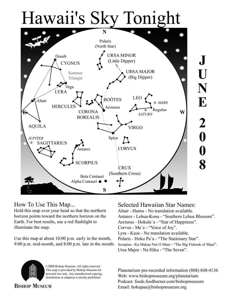
The patterns we see in the sky exist only in our imagination. The points of light we group to create the shapes we call constellations are arbitrary and usually don’t have any connection with each other at all except that they happened to line up in someone’s mind at one time. The 88 “official” constellations are recognized by a group of professionals called the International Astronomical Union to help keep order and structure to the science of astronomy. Otherwise, imagine what chaos might reign—how would anyone know how to distinguish one part of the sky from another if names were random? For instance, the constellation Crater the Cup in the southern sky next to Corvus looks remarkably like my Weber grill, but I can’t very well start referring to it as such. As it is, we sometimes “shorten” the constellations anyway. Sagittarius is often referred to as the Teapot, and part of the Big and Little Bears are called the Big and Little Dippers, respectively.
Informal groupings or segments of constellations are called asterisms. They are usually parts of constellations that are more easily recognized, like the Dippers and the Teapot, and at times the references are updated. Some constellations are simply easier to recognize by these nicknames. I have heard the constellation Boötes the Herdsman referred to as a “bowtie” or “ice cream cone”, which most people relate to better.
Sometimes asterisms include groups of stars or constellations, like the Summer Triangle. Known anecdotally as a basic element of celestial navigation, the Summer Triangle is comprised of the three brightest stars in three separate constellations forming a large, distinctly triangular shape in the sky. First to rise in the east is the star Vega in the constellation Lyra the Lyre. Lyra is a small constellation that takes a bit of effort to imagine the harp-shaped instrument from the parallelogram of stars, but it is an area rich in telescopic sights. One is the famous Ring Nebula, M57—a little smoke-ring object that is the remains of a dying star seen at the center of the ring.
Vega is a white star and the fifth brightest star in the sky. Twelve thousand years ago Vega used to be our North Star, but because the Earth slowly “wobbles” (think of a spinning top, except our wobble is 26,000 years long!) the North Pole points toward different stars periodically. Right now, almost halfway through the wobble’s circle, Polaris is our North Star but in another 14,000 years Vega will take that title again.
Almost two hours after Vega rises the second point of the Triangle appears in the east in Cygnus the Swan. Although this constellation can be easily visualized as a bird, it does have an asterism associated with it. Part of the body and wingspan of the Swan is known as the Northern Cross. The star Deneb is the tail feather of the bird and is the brightest star in that constellation. Opposite from Deneb is an interesting star called Alberio. With a low powered telescope or even binoculars what looks like a single star will split into a beautiful sapphire blue and golden pair of stars.
A half hour later, Altair in Aquila the Eagle makes its appearance over the eastern horizon. Altair and Vega represent two figures in Japanese folklore that are celebrated with a national holiday in the country. Altair is the handsome herdsman Hikoboshi (also known as Kengyu) that fell in love with Orihime (Vega), the beautiful fabric-weaver. Their preoccupation with each other began to interfere with their duties, and as a result the gods separated them across a vast river in the sky. You can see that “heavenly river” in the dark sky as the white band of light called the Milky Way.
Fortunately, the story doesn’t end here—the gods heard the unhappy cries of the two lovers and took pity on them. On the seventh day of the seventh month, the two are united for one day as a flock of magpies build a living bridge to bring the two together. Today this occasion is celebrated by a festive holiday called Tanabata in Japan on July 7, although in early times this date was determined by the lunar calendar.
Following the Summer Triangle (and the parallelogram of Lyra) is the big Square of Pegasus. But because it is not included on this month’s map, I will save that “astro-geometry” lesson for another month!
The Planets
Earth:
Summer kicks off, at least astronomically, with the solstice on June 20. At 2:00 P.M. HST the sun crosses from the southern hemisphere into the northern hemisphere, marked by the celestial equator. (The celestial equator is an imaginary line that extends the Earth’s equator into space)
Mercury:
Mercury is passing in front of the sun for most of the month and will reappear in the morning sky during the last week of June. It hangs over the red “bull’s eye” of Taurus in the light of the rising sun.
Venus:
Venus is behind the sun right now, what is referred to as superior conjunction. It will be another month before it will appear back in the evening sky and blaze in the west after the sun sets.
Mars:
Mars quickly moved from Gemini through Cancer last month and will settle in the constellation Leo during June. Saturn has also been a resident of Leo recently and the two planets are heading for a conjunction in July. You can watch the Red Planet edge closer to yellowish Saturn over the month, with Regulus (the brightest star in Leo) in the middle.
The NASA mission to Mars, called Phoenix (see May’s article) will make its descent to Mars on May 25. Unfortunately I cannot update the status of this mission because this article is filed before this date, but I will definitely talk about Phoenix next month.
Jupiter:
The King of Planets rules the night, shining brighter than any other object besides the Moon this month. Jupiter rises by 10:00 P.M. in early June and about two hours earlier by the end of the month. On June 18, the full Moon enters Sagittarius, the same constellation as Jupiter, and the next evening the waning Moon moves just south of the giant planet.
Saturn:
Look for Saturn high in the west at nightfall during the first half of June, then only about halfway up in that direction by the end of the month. The rings of the gas planet is continuing to tip edgewise to our line of sight and well worth watching over the upcoming months. You will need a telescope to really appreciate this sight, however.
Questions? Contact Carolyn Kaichi @ hokupaa@bishopmuseum.org or 847-8203.
For information ad videos about visiting Hawaii in general and touring the Big Island in particular, visit www.tourguidehawaii.com and www.lovingthebigisland.wordpress.com.
Subscribe to:
Posts (Atom)

