Kilauea Eruption Status
(Reprinted from the U.S. Geological Survey, Hawaii Volcano Observatory webpage)
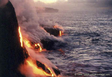
Lava from the 2007 Thanksgiving Eve Breakout (TEB) flow, erupting from fissure D of the July 21 eruption, continues to flow through what remains of the Royal Gardens subdivision and across the coastal plain. On Wednesday, March 5, the flow entered the ocean in the vicinity of Kapa`ahu. The Waikupanaha delta has since grown to a width of about 1,000 m (3,280 ft) and has multiple entry points. On March 15, another branch of the flow reached the ocean farther to the east, within a few hundred meters of the lava viewing area. As of Thursday, March 20, both the Waikupanaha and Ki entries remained active, though the Waikupanaha entry is far more vigorous.
The public should be aware that the ocean entry areas could collapse at any time, potentially generating large explosions in the process. The steam clouds rising from the entry areas are highly acidic and laced with glass particles. Do not venture onto the lava deltas. Even the intervening beaches are susceptible to large waves suddenly generated during delta collapse; these beaches should be avoided. Check the County of Hawai`i Civil Defense website (http://www.lavainfo.us) for information on public access to the coastal plain and ocean entry.
In the past week, sporadic breakouts, some large enough to form channelized `a`a flows, have burst from the lava tube on the steep slopes within the Royal Gardens subdivision. A few of these have reached the base of the pali before stalling. Other breakouts have been spotted at the top of the pali near the upper boundary of the Royal Gardens subdivision. Closer to the TEB vent, an area of persistent breakouts on the northeast side of the shield complex also continues to produce small flows. These northeast-directed flows are restricted to a broad, flat area on the south side of Kupaianaha.
Weak incandescence has been intermittently observed at night in Pu`u `O`o in the past week. As in years past, Pu`u `O`o likely is serving as a large chimney, beneath which lava is briefly stored and substantially degassed on its way to the eruption site.
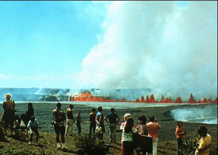
On March 11, a new fumarole appeared low on the southeast wall of Halema`uma`u Crater, within Kilauea's summit caldera. The new vent is located directly beneath the Halema`uma`u Overlook about 70 m (230 ft) down. Incandescence could be seen at this vent, starting on March 13, and, by March 18 incandescence had grown to cover an area about 30 m (98 ft) across. At 2:58 a.m. on March 19, a small explosion occurred from this fumarole. The explosion scattered rock debris over an area of about 75 acres, covering a narrow section of Crater Rim Drive, the entire Halema`uma`u parking area, and the trail leading to the overlook. The overlook was damaged by rocks that reached up to 90 cm (3 ft) across. No lava was erupted as part of the explosion, suggesting that the activity was driven by hydrothermal or gas sources. The new explosion pit continues to glow at night, with incandescence reflecting on the fume emitted from the vent.
Sulfur dioxide (SO2) emission rates from the summit area have been substantially elevated at 2-10 times background values since early January. During these conditions, SO2 concentrations frequently exceed 1 ppm for much of Crater Rim Drive between Halema`uma`u parking lot and the southwest rift zone. SO2 concentrations exceed 20 ppm for approximately 200 m (650 ft) of the road between the Halema`uma`u parking lot and the south caldera pullout.
The increase in sulfur dioxide emission rates at the summit means that SO2 concentrations are much more likely to be at hazardous levels for visitor areas downwind of Halema`uma`u, especially during weak wind conditions or when winds blow from the south. Most people are sensitive to sulfur dioxide at these levels, especially children, individuals with asthma, chronic obstructive pulmonary disease (COPD), or other breathing problems. Stay informed about SO2 concentrations in continuously monitored areas (Jaggar Museum and Kilauea Visitor Center) by visiting the Kilauea Visitor Center and the web at:
http://www2.nature.nps.gov/air/webcams/parks/havoso2alert/havoalert.cfm. To minimize these potentially harmful effects, the Hawai`i Volcanoes National Park has closed all access to the southern half of Kilauea caldera.
Two earthquakes beneath Hawai`i Island were reported felt within the past week. A magnitude-3.4 earthquake occurred at 2:22 a.m., H.s.t., on Friday, March 14, 2008, and was located 6 km (4 miles south of Mauna Loa summit at a depth of 3 km (2 miles). A magnitude-2.4 earthquake occurred at 2:28 p.m. on Saturday, March 15, and was located 2 km (1 mile) northwest of Pahala at a depth of 13 km (8 miles).
Mauna Loa is not erupting. One earthquake was located beneath the summit. The rate of extension between locations spanning the summit, indicating inflation, has decreased to values below current detection limits.
Visit our Web site (http://hvo.wr.usgs.gov) for daily Kilauea eruption updates and nearly real-time Hawai`i earthquake information. Kilauea daily update summaries are also available by phone at (808) 967-8862.
For maps, photographs, and more current information see Kilauea's eruption update page. Visit The Hawaii Center for Volcanology for captivating eruptive photos and a history of the eruption.
For more information on visiting Hawaii Volcanoes National Park and seeing the volcano, visit www.tourguidehawaii.com.


