Showing posts with label black sand beach. Show all posts

Friday, October 9, 2009

Frank's Hawaii Travel Hints #9: Made for Adventure: The Jungles, Volcanoes, Hot Springs and Tidepools of Puna!

Frank's Big Island Travel Hints #9: Made for Adventure: The Jungles, Volcanoes, Hot Springs and Tidepools of Puna!
by Frank Burgess, brought to you by Tour Guide Hawaii

Tour Guide Hawaii is proud to announce the release of their new iPhone and iPod Touch App available at iTunes...this App will help you plan your trip to Hawaii, help you decide what you want to see, how you want to see it and help you get there with GPS, interactive maps and on-board driving instructions. The Tour Guide App presents hours of interesting videos and information about places of historical, cultural and recreational interest, giving you a sense of the people, the natural history and the unique specialness of each destination. The information is so comprehensive and complete they even tell you where all the public restrooms are! What else will Tour Guide help you find? Let's look at a trip north from Kona along the Hawaii Belt Road to the Waikoloa area...Tour Guide will not only help you find many amazing sights along the way, it will tell you all about them, what to take and what to expect.

Today's hints cover the area from McKenzie State Park in Puna District back to Kona. Driving along the Puna Coast, through recent lava flows and ageless jungle, through Ka'u and into Puna there several fantastic places to stop and explore, but there is also a lot of lovely, open countryside for several miles, so enjoy the panoramic views. Your Tour Guide download from iTunes will give you more detailed information about this area.

Deeper into mysterious Puna!

As you continue along the coast road, you will next encounter McKenzie State Park. Here the Ironwood trees create an unusual ambience of a pine tree forest. The sheer cliffs and majesty of the ocean beg for photographing. Swimming would be near impossible here, but the hiking is spectacular. Tour Guide will give more information about this other- worldly park. A permit is required for camping and the facilities are a bit run down, but it is secluded, private andbeautiful.

Not far away is Kahena Beach. This beautiful black sand beach involves a bit of a scamper to get down the cliff, but is well worth the effort. Tour Guide will give you the easiest path to take. You may notice that this beach is “clothing optional”, thus it’s popularity. Swimming here is good, but currents can be strong if you get too far from shore.

Drive just a few miles further and you come to what used to be the town of Kalapana. Kalapana and Royal Gardens were destroyed in the lava flows during the late1980’s.

What remain are a few homes and businesses where the road now ends. From here one can see the plume of smoke coming from the vent upslope. Sometimes the lava reaches the ocean about 2 miles from this spot.

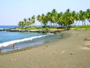
A short five minute hike will bring you to Kaimu Beach, the newest black sand beach on the island. Tour Guide will give you the rich history of the ancient fishing villages that were here and the touching stories about the palms at Kaimu Beach.

Heading back from Kalapana, you will want to take Highway 130 toward Pahoa. This is your best chance of watching Kilauea erupt. Just a few hundred yards north of Kalapana, is the old turn off to Royal Gardens. This is now the official County of Hawaii Lava Viewing Site. Drive as far as the attendants will allow you, park and walk into where you can safely view the lava flowing into the ocean. Daily updates on the volcano and conditions at site are available at the Hawaii County Lava Viewing Desk, phone number 808.961.8093; more information is here and here.

Farther along the highway to Pahoa, you will see a “scenic turnout” where you can view the Puna Geothermal Vents. Here a company has tapped the natural steam to create electricity from these fumaroles. Tour Guide will show you how, with a short hike off the road, and you can sit in one of these natural sauna vents for some real relaxation.

Now you’re ready to head back to Kona. Take Highway 130 to Highway 11 and go south. If time permits, you may want to stop in Volcano Village, just off the highway, for some food, gasoline, shopping or maybe even some wine tasting. This may be the last gasoline available until you get back to Kona. Find your hotel in your Tour Guide and get turn-by-turn directions right to the door.

To see the new iPhone/iPod Touch App, please visit http://www.tourguidehawaii.com/iphone.html. The best of Tour Guide Hawaii's free content about traveling to, and exploring, the Big island, can be found here. For more information on traveling to Hawaii in general and on touring the Big Island in particular, please also visit www.tourguidehawaii.com and www.tourguidehawaii.blogspot.com.

Copyright 2009
by Frank Burgess; photography copyright 2009 by Donald B. MacGowan. All rights reserved.

Wednesday, March 4, 2009

Big Island Day Trips # 3: Kona Coast to South Point and Ka'u

Trip 3: South Kona, Ka’u and Puna: Wild Southern Coastline, Immense Volcanic Mountains and Mysterious South Point

Approximate minimum time start to finish (to see every site): 12 hours.

Headed south from Kona, connect to Highway 11 and drive 20 minutes to sample Kona Coffee. Numerous farms offer tours to discover the history and processing of this highly prized beverage. In this region are Kealakekua Bay and the Captain Cook Monument, the locations where Hawai'ian history was forever changed and the best snorkeling in the state. Follow the beach road 10 minutes to Pu'u Honua 'O Honaunau National Historic Park. Discover why this spiritual complex was a "place of refuge". Continuing south 1 hour, after some beach time and a short hike, is South Point Road. This is where early Polynesians arrived and started a village based on the rich fishing grounds offshore. Nearby is the trail for a 3 hour round trip hike to a Green Sand Beach (bring drinking water). Then drive 30 minutes south to visit endangered Hawksbill Sea Turtles at Punalu'u Black Sand Beach. From Punalu'u it is a 2 hour drive back to Kona.

Leg 1) Start at north end of Keauhou Historic District on Ali’i Drive, head south on Ali’i Drive to jct with Kamehameha II Hwy; east on Kamehameha III to Hwy 11. Take Hwy 11 south to jct with Hwy 160, just south of the town of Captain Cook. Head downhill on Hwy 160 to Napo’opo’o Village, turn north on Pu’uhonua Beach Road to Kealakekua Bay State Historical Park at end of road; this is where you view the Captain Cook Monument.

From Hapaialii Heiau to Keeku Heiau, Keauhou Historic District, Kona Hawaii: Photo by Donnie MacGowan

Keauhou Historic District and Kona Coffee

For almost 400 years, temples and palaces along the Kona coastline served as a kind of "Rome of the Pacific", a great political, religious and cultural center in Polynesia, until the capital was moved to Honolulu in 1850 by Kamehameha III. The most important, interesting and best preserved historical and cultural sites lie within the Keauhou Historic District, between Kahalu'u Beach Park in Kailua running south 6 miles to Kuamo'o Bay in Keauhou. The District contains perhaps a dozen fascinating sites that are easy to walk to, well maintained and quite interesting.

To see the numerous fascinating and important archaeological sites in the Keauhou Historic District, it is necessary to park your car in the free parking at either Kahalu’u Beach Park or the Keauhou Beach Resort and explore on foot.

Just uphill from the Historic District is the Kona Coffee District. Hawaii is the only state in the union which produces coffee, and Kona coffee is perhaps the finest in the world. Over 2 millions pounds of coffee a year are produced on about 600, 2-3 acre farms; tours of coffee farms and roasteries are available.

Captain Cook Monument and Kealakekua Bay from Manini Beach at Napo'opo'o, Kona Hawaii: Photo by Donald MacGowan

Kealakekua Bay Historical District and Captain Cook Monument

A place of both dramatic historic events and unparalleled scenery, beautiful and now peaceful Kealakekua Bay (Pathway of the Gods) opens beneath steep, beetling cliffs on the ancient surfing beach along the shoreline of Napo’opo’o Village. The site of arguably the most important event in the history of Polynesia, home to pods of frolicking dolphins, providing some truly breathtaking snorkeling, Kealakekua Bay is one of the most magical spots in the State of Hawai’i.

Across the bay from Napo’opo’o stands the solitary white obelisk that marks the lonely Captain Cook Monument. It was in this broad bay that Captain James Cook made his deepest impression on, and longest visit with, native Hawai’ians when he first arrived late in November of 1778; and it was here where he met his tragic end in February 1779 during his second visit. At the State Park at the end of the road in Napo'opo'o are picnic facilities, pavilions and restrooms.

Pu'u Hounua O Hounaunau, The Place of Refuge: Photo by Donald MacGowan

Place of Refuge: Pu’u Honua O Honaunau National Historic Park

A beautiful, peaceful, restful piece of Old Hawai’i, Pu’u Honua O Honaunau is a place of ease and regeneration for weary and jaded souls. Of enormous historical and cultural significance, the sacred grounds at Honaunau are the best-preserved remaining Pu’u Honua, or Place of Refuge, complex in Hawai’i. It is also a wonderful area to wander, snorkel, relax and picnic. For anyone who had any doubts about what Old Hawai’i was like, a trip to Honaunau will fill your imagination, your camera and your spirit.

A complex and strict order of law, known as the kapu system, controlled and governed everything in ancient Hawai’i. Under this system, judgment was death, immediate and final, unless the accused could escape to one of the designated places of refuge. There the accused would undergo a cleansing ceremony, be absolved of all crimes, and allowed to return to his family free of onus. The National Park has a Visitor's Center and bookshop, full picnic and restroom facilities. Although no swimming or snorkeling is allowed within the Park, adjacent is Two-Step Beach on Hounaunau Bay, one of the premiere snorkeling spots on the Island.

Leg 3) Return to Hwy 11 via south leg of Hwy 160, continue south on Hwy 11 to Ho’okena Beach Road; Ho’okena Beach Road west to Ho’okena Beach.

Ho'okena Beach, South Kona: Photo by Donald MacGowan

Ho’okena Beach County Park

Brilliant snorkeling, decent boogie boarding, passable shell collecting and wonderful camping—it’s a wonder Ho’okena Beach is not more popular with visitors. Nestled alongside the ruins of Ho’okena Village, this beach is a wonderful place to spend a morning or a weekend.

Frequented by dolphin, stuffed full of pelagic and reef fish and turtles and boasting crystal clear, warm and calm waters, Ho’okena is a must-see beach for avid snorkelers and divers as well as sea kayakers. During the winter months, female Humpback whales and their babies frequent the waters off this bay.

Wonderful beach camping, new showers and restrooms, picnic tables and abundant fresh water make this county park a gem. Camping is by permit only on a first come-first served basis.

Leg 4) Return to Hwy 11 via Ho’okena Beach Road; continue south on Hwy 11 to Miloli’i Road; Miloli’i Road to Miloli’i Beach Park; trail to Honomalino Beach.

Honomalino Beach, South Kona, Hawaii: Photo by Donald MacGowan

Honomalino Bay

A true gem of West Hawai’i and rarely crowded, Honomalino Bay is reached by a 20 minute hike from the south end of Miloli’i Beach County Park. The hike starts between the bathrooms and a yellow church and is always along the right fork of the trail, in and out of the surf line, to avoid private property.

Snorkeling is very interesting on the north side in the rocks, when the surf is low. The water, though very clear, is sometimes quite cold due to spring discharge in the sand on the beach. There are no services here, leave no valuables in your car.

Leg 5) Return to Hwy 11 via Miloli’i Road and continue south on Hwy 11 to South Point Road; South Point Road to South Point.

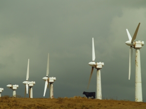
Cow and Windfarm: South Point--Ka Lae--Ka'u Hawaii: Photo by Donnie MacGowan

South Point (Ka Lae)

Haunting, windswept, wild, empty, beautiful. Imagine the gratitude and wonder of the first Polynesians who, after voyaging at sea without sight of land for more than a month, finally made land here at Ka Lae. Polynesians established a thriving colony based upon the incredibly rich fishing grounds just offshore. South Point is the farthest point south in the entire United States. The road to Ka Lae from the Hawai’i Belt Road is infamous although greatly improved in recent years; check your rental agreement before driving here. There are no services…plan and act accordingly.

Leg 6) Head back north on South Point Road to Kaulana Boat Launch Road; take road to boat launch, Green Sand Beach trail to Green Sand Beach.

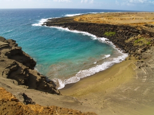
Mahana Green Sand Beach, South Point Hawaii: Photo by Donnie MacGowan

Trail to Green Sand Beach

Absolutely unique to the island of Hawai’i are the handful of green sand beaches composed of crystals of the semi-precious mineral olivine (also known as peridot). The green sand beach at South Point is the best known, largest and most accessible of these. The bizarre color of the water shrieks for underwater photographs. Watch for strong currents; do not go out far nor if the surf is high or there are strong winds.

To get there, follow signs to Kaulana boat launch; park left (south) of the boat launch. Hiking distance is 2 ¼ miles each way along rolling tropical prairie. Stay in sight of the shore and you cannot get lost. Although tricky to spot on the way down, from the beach looking up the way back to the crater rim is easy to follow. There are no services here; plan and act accordingly.

Leg 7) Return from Kaulana Boat Launch Road to South Point Road to Hwy 11; proceed southeast on Hwy 11 to Punalu’u Road; Punalu’u Road to Punalu’u Black Sand Beach Park.

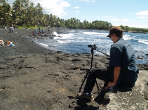
Bradford MacGowan Filming at Punalu'u Black Sand Beach, Ka'u Hawaii: Photo by Donald MacGowan

Punalu’u Black Sand Beach Park

A truly remarkable place of great peace, beauty and spiritual healing, Punalu’u’s black sand beach is world-renowned. Endangered Hawai’ian Green Sea Turtles swim the waters here and bask on the beach. The wildness of the ocean and the serenity of the freshwater fishpond and coconut palm-shaded beaches make this an ideal place to spend some soul-recharge time. The ocean here can be rough, so use caution when swimming.

Available services include water, picnic tables, restrooms, electrical outlets, and pavilions, parking; camping is by permit only. During peak tourist time, there is a souvenir stand with some packaged food items and canned drinks for sale, otherwise the nearest food, gasoline and other services are in either Pahala or Na'alehu.

Leg 8) Return Punalu’u Road to Hwy 11; take Hwy 11 west and north to Kailua Kona.

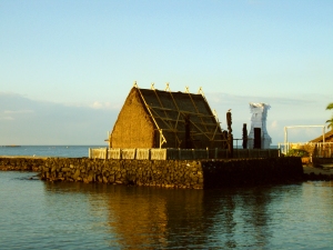
Sunrise at Ahu'ena Heiau in Kailua Kona, Hawaii: Photo by Donald MacGowan

For more information on traveling to Hawaii in general and touring on the Big Island in particular, please visit www.tourguidehawaii.com and www.lovingthebigisland.wordpress.com.

Tuesday, January 13, 2009

Kalapana, Hawaii: From the Fires of Hades to the Eden of Rebirth

Kaimu Black Sand Beach at Kalapana, Hawaii: Photo by Donnie MacGowan


By Donald B. MacGowan

On the southeast coast of the Big Island of Hawaii runs the Kapoho-Kalapana Highway, perhaps the only road in the world named for two cities that have been buried by volcanic eruptions. Before the destruction of these towns, this area harbored some of the last refuges of the native Hawaiian way of life--it was a safe haven from the ravages, temptations and noisome encroachments of western civilization. Here were villages of Hawaiians, living as they have for hundreds of years, fishing, farming and keeping their culture, their way of life, their people, alive and vital.

But life on an active volcano is uncertain. Life on an island with 3 active volcanoes, as Hawaii has, is perilous. And for this particular corner of Hawaiian paradise, Madame Pele, the Goddess of the Volcano, began to have other ideas.

In 1990 Pele determined it was time for some serious geographical reorganization. Lava flows from Kilauea’s East Rift swarmed down the mountain and engulfed the villages of Royal Gardens, Kaimu and Kalapana, destroying virtually everything. Immolated and buried were centuries-old fishing villages and a world famous black sand beach. The road ends today where Kaimu Black Sand Beach once stood, and is now a thousand yards and more inland.

When the lava came, it wiped out not just homes, gardens, crops and material things, it wiped out a way of life and a landscape cherished by generations. Imagine the staggering losses to the community. The coconut grove by the beach where, for a thousand years, the Kahunas had blessed the fishing canoes, was not only wiped away and covered with lava, but the landscape was altered so permanently and completely that none are even sure where it used to be. The spots where generations of fathers taught their sons to fish, gone. The groves where mothers sat with their daughters passing on the arts of weaving along with the family stories, gone. The beach where thousands of young lovers had walked the moonlit surf, arm in arm, for centuries, and where perhaps not a few babies had also been made, gone beneath 50 feet and more of lava. Everything gone; a landscape, a way of life, an entire culture.

It was from her vision of strength and a refusal to let her community die, rather than feelings of loss and desolation, that inspired one local resident to replant and reestablish the area. Not to just replant her land, but the entire village. Inspired, tirelessly, steadily, she worked planting hundreds, then thousands, of sprouted coconut and other palms and encouraged others in her community to join in. Even when she discovered she had a terminal disease, she selflessly redoubled her efforts, continuing her campaign to replant and recover the village, the community pitching in even more after she passed away.

Today there are literally thousands of young trees growing on the no-longer barren lava, and a new geography for new lives and new memories is being born. Her vision of rebirth, now being realized, is a moving testament to the power of love of ones’ community and commitment to ones’ culture. This living vision of young palm trees is an amazing, enduring monument to her optimism, faith and perseverance, and to that of her community. One of the truly most moving stories in the Islands, this place has to be seen to be appreciated.

When you visit Kalapana today, the devastation of 20 years ago is still obvious, but so is the vision of rebirth. Although none are yet as tall as a man, the rebuilt trail to the new black sand beach, Kaimu Beach, is lined with the young palms. You should take time to wander out to the beach, over the acres of new land, and look back at where the village of Kalapana once stood. Near the parking area along the path are fossils, lava casts, of palm trees, coconuts, pandanas fruit and other plants…keep a sharp eye out, they are everywhere. Swimming is hazardous at the new beach, so is surfing, the ocean currents being strong and treacherous. But take some time to relax, wade, feel the sand beneath your feet and amidst the lunar desolation of the fresh lava flows, contemplate the drive of one dying woman to rebuild a world she loved from a devastation few of us can imagine.

From the lava hillocks along the trail you can get nice views of the eruption plume at Pu’u O’o, up on the flank of Kilauea as well as the steam clouds down a few miles along the coast where the lave enters the sea at Waikupanaha. This is one of the few places where both can be seen easily and at the same time.

Back at the parking area at the road’s end, look a bit farther to the west and find Uncle Robert’s House, one that was spared the destruction, where a display of photos of the lava flows and the village in pre-disaster times in a miniature museum can be found, along with an interesting nature trail. The stop is worth your time, and be sure to leave a donation in the offering jar.

The extreme devastation suffered by the people of Kalapana may be a long way from our own life experiences, but we should take inspiration and example from their vision, their optimistic perseverance and their deep love of, and commitment to, their way of life.
 

Casino Bonus no Deposit