Showing posts with label t. Show all posts

Wednesday, December 3, 2008

What Do I Do On the Big Island? Explore The Incomparable Hamakua Coast!


Photo by Donald MacGowan

The Hamakua Coast, running up the windward side of the Big Island from just north of Hilo to the north tip island at Upolu Point, is one of the most magical, enchanting and memorable parts of the Big Island. To few people take the time to really see the depth and grandeur of the Hamakua District. Once the center of the sugar industry in Hawaii, Honoka'a, and the rest of District comprised of sweeping farm land, torrid jungle canyons and thousand foot lacy waterfalls, sank into pot-plantation era torpor, alowing the decades to simply wash over it. Experiencing a resurgence of energy, population and interest, Hamakua is remaiking itself as a tourist mecca and growing community of entrepreneurs, Eco-friendly industries and boutique agricultural businesses. You owe it to yourself to discover, explore and fall in love with this unique and special part of the Hawaii's Big Island.

Pepe’ekeo Scenic Drive

Located just a few minutes north of Hilo on Highway 19, this “Old Road through Old Hawai'i”, a four-mile-half hour scenic wander, parallels Highway 11 but is removed worlds away from the traffic and hustle along the main road. Rolling along old cane fields, jungle-canopied in places, passing waterfalls and crossing creeks, the Pepe’ekeo Scenic Drive is a special treat for the visitor who may be thinking they waited a century too long to visit Hawai'i. On a sunny day, on a rainy day, it doesn’t matter; this scenic drive is a joy.

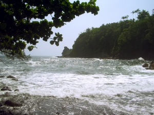
A scenic overlook of Onomea Bay, near the head of the trail, reveals the wildly scenic, untamed coastline and canyon mouth, beckons casual hikers to explore Onomea Bay.

Photo By Donald MacGowan

Onomea Bay Trail

Only a few miles north of tame and sedate Hilo Bay, Onomea Bay is subject to the full fury and magic of the open Pacific Ocean. Rugged, jagged, majestic, the wickedly sculpted cliffs along the bay belie the easy 15 minute walk down to the beach. Accessible to most walkers of even marginal condition, the trail leads alongside a botanical garden (be sure not to wander through any their gates unless you are a paying customer) and falls forthrightly down to the canon mouth, past a tiny waterfall at the end of the stream and to the beach. A lovely walk and a wildly inspiration place; if you have an extra forty minutes to spare, this walk is well worth the time.

The fishing here is great but we don’t recommend swimming here due to the currents and rip-tides.


Photo by Donnie MacGowan

Akaka Falls

There is a reason that Akaka Falls rates as the most visited tourist site on the island of Hawai’i. Simply put, the 420 foot, free falling plunge of clear water down a fern festooned cliff is an amazing and beautiful site. Leaving the parking lot, the loop trail immediately splits. Going left through fern, ginger, impatiens and bamboo, one reaches Akaka Falls in 5-8 minutes of ambling. If you turn right, the trail loops up and down some hills, through a wonderful jungle of flowers, ferns, heliconia, palms and bamboo to 100 foot tall Kahuna Falls in about 15 minutes of walking; Akaka Falls is then reached by following the same path another 5 minutes and 5-8 minutes after that you are back at the parking lot.

Almost every town in Hawai’i has a “Wainuenue street”. From the Hawai’ian syllables “wai” meaning “fresh water” and “nue” meaning “colorful” or “dancing”, the word “wainuenue” refers to the rainbow seen in waterfalls. If you are lucky, and approach Akaka Falls on a sunny morning when the sun shines into to grotto, you may be blessed with seeing this lovely Hawai’ian icon, the wainuenue.


When visiting Akaka Falls, be sure to save some time to explore the shops, galleries and cafes of Honomu on the way back to the highway; it’s unlike anywhere you’ve ever been before…guaranteed.

Hakalau Beach Park

Oh, wow! Most definitely the tropical paradise you dreamed about visiting, this thick, lush jungle canyon is a stunning remnant of Old Hawai'i, leading along a rushing stream to a narrow canyon festooned with tropical blossoms, vines and palms to a sandy beach where the surf is nothing short of amazing.

Although locals surf and swim unconcernedly here, the visitor is advised to admire the water, but not go in. Not only are the waves, currents and tides lethally treacherous here, but stream mouths and murky water are prime hunting grounds of Hawai'i’s own tiger, Mano, the shark.


There are no services at Hakalau Beach.


Kolekole Beach Park
The river you saw magnificently leaping with such glorious abandon off the cliff at Akaka Falls ends its journey to the sea by sluicing down through this Koa-tree filled canyon and smashing into the surf at Kolekole Beach Park. Lawns, picnic facilities, a wild beach, a jungle canyon and a water-fall festooned swimming hole round-out the amenities at Kolekole Park.

This is another beach where the visitor is admonished to swim only when the surf is flat and even then with great caution.

Laupahoehoe Train Museum

Back in the day, built around the turn of the century, various train lines nearly circumnavigated the Big Island, carrying raw cane to refineries and sacks of sugar to quaysides dotted here and there around the island. The coming of a large military presence during the Second World War was marked by an era of road building which more or less obviated the need for the trains. Tracks and trestles were cannibalized for wood and metal in the war effort and slowly the Big Island train industry was groaning to an ignoble halt when the tidal wave of 1946 destroyed much of the remaining track; today the carcass of Big Island railroading is all but pillaged into oblivion.

Here at Laupahoehoe, preserved alongside the one-time loading platform, is the Laupahoehoe Train Museum, stuffed full of interesting artifacts and photos and staffed with enthusiastic, well-informed, fun--- and did we mention enthusiastic?—docents. Look for “Old Rusty” outside the museum—a restored engine and caboose.

Laupahoehoe Train Museum and its associated gift shop, featuring many handcrafted gift items made by local artisans, are open daily, from 9 am to 4:30 pm on weekdays, and from 10 am to 2 pm on weekends. Public restrooms are available. Admission is $3.00 per adult and $2.00 for students and seniors.

Kalopa Native Forest State Park and Recreation Area

A small park with numerous hiking trails, Kalopa showcases the upland, tropical forest of the northeastern part of Hawai’i Island. Amenities include picnic tables, tent camping and small, if somewhat ragged, cabins for rent, a wonderful forest ambiance and absolute silence. This a great place to escape the rattle and hum of East Hawai’i.

Honoka’a Town

Built in the era of great plantations and left culturally and economically isolated after the collapse of the sugar industry, until recently Honoka’a and the Hamakua Coast were content to drowse along through the decades. A boom in real estate and a return of vital human energy to the area has made a literal renaissance of the town of Honoka’a. A bustling hub, it boasts numerous wonderful restaurants, gift and boutique shops and the highest density of antique shops on the island. Be sure to stop to explore a little, have a meal or do some shopping in scenic Honoka’a on your way to or from Waipi’o Valley…it’s a fun, happening kind of place. Just remember, it’s a “happening kind of place” in the Hawai’ian sense—which means a little laid back, and always steeped with aloha.

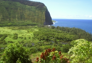
Photo by Dr. Donad B. MacGowan

Waipi’o Valley

Waipi’o Valley is arguably the most magical place on the Big Island. The steep canyon walls and verdant fields of the valley floor, the mile long black sand beach and numerous immense waterfalls that line the valley walls all call out to the visitor for exploration.

Always listed among the most beautiful spots in the State of Hawai’i, this valley is as hauntingly lovely as it is difficult to see in its entirety.


Although the mile-long black sand beach is gorgeous, the forest and jungle canyon floor and walls amazing and the numerous, high-flying waterfalls compelling, it's a long and steep hike down in, and an equally long, but much more arduous, hike out. The road is windy and dangerous to drive...we don't recommend it.

Tours down into the valley in vans, on horse drawn wagons and ATVs can be booked in Honoka’a. Over-flights in fixed wing aircraft and helicopters also offer fine venues from which to see this amazing piece of Hawai’i.


For more information on traveling to Hawaii in general or touring the Big Island in particular, visit http://tourguidehawaii.com or www.lovingthebigisland.wordpress.com.

About the Author: Popular television personality and award-winning independent filmmaker Dr. Donald B. MacGowan originally pursued a career in academics, earning two B.Sc. degrees, a dual M.Sc., and a PhD.; co-authoring over 5.2 million dollars in grants, and publishing more than 200 refereed journal articles, abstracts, etc. Gaining sanity somewhere in that process, he quit the academic rat race and began to live. Donnie is an accomplished, prolific alpinist, having climbed on 5 of the seven continents, putting up more than 150 first ascents on rock, ice and snow, and a dozen first ski descents. He has written, directed and produced short and feature length films on health, travel, mountaineering and life in a touring rock band. Donnie records and tours relentlessly with his Celtic Punk fusion band "Fatal Loins"--although nobody much seems to care for their music. A Hawaii resident since 2000, he quietly and humbly inhabits Kailua Kona, doing environmental good works, surfing the be-jeezis out of the local waves and frenetically producing somewhat bizarre and mildly disturbing programs for local television which have recently been lauded as: "Ignorant", "Arrogant" and "Totally Insane". You may say what you wish about him, Donnie does not care. For somewhere underneath those swaying palm trees, in those warm aloha breezes, he is far too busy praying for good surf to hear you...


Friday, May 30, 2008

Pele's cooking more than vog -- "precious" jewels also stewing in her cauldron


Both opague and glassy crystals are native, or pure, sulfur. The glassy crystal is about 2 mm (0.08 inches) long.
Photo by M. Sako


After the series of explosions at Halema`uma`u Crater, the overlook area appeared to be a stark, boulder-strewn field completely devoid of life. To the casual observer, little beauty could be seen in this otherworldly landscape. But on closer inspection, the field of rocks that covers Halema`uma`u reveals an array of colors - rocks blood-red and ochre, canary yellow, pinks of every hue, and a broad range of whites. These colors can appear as non-glossy lacquer, or as a brilliant glass, reflecting light. Photos don't do justice to the astonishing beauty of these rocks. But under the microscope their radiance is clearly revealed.

Some of the minerals have familiar names, like sulfur and gypsum. Others are, perhaps, more foreign, like alunite and jarosite. Individual colors usually cannot be assigned to specific minerals, because many mineral share the same, or similar, colors. Because of this, a geologist in the field uses a combination of color, shape (also known as crystal habit), and other physical characteristics to identify a mineral.

At Halema`uma`u, however, the number of minerals present is relatively small, and some generalizations based on color can be made. For example, the canary-yellow rocks are almost always composed of native sulfur. Perhaps you've seen the conspicuous yellow patches of ground in Halema`uma`u or at Sulfur Banks. Native sulfur is a very common mineral at volcanic fumaroles around the world.

The ochre, blood-red, or yellowish-red rocks are usually iron-oxide minerals, like hematite or goethite. These minerals are also very common in volcanic terrains.

The white minerals at Halema`uma`u are among the most difficult to identify, because so many different minerals may take on this color. However, most of the white-colored rocks you see there are actually the white crusts formed by a family of related minerals known as sulfate salts. Gypsum is one of these salts.

As beautiful as these Halema`uma`u minerals can be, they are of little economic value. But as the saying goes, one person's lead is another's gold. Indeed, for a geologist seeking to understand how the volcano works, these minerals are priceless jewels.

By studying volcanic systems like Kilauea, geologists have come to understand that each mineral is formed from a recipe that specifies temperature, pressure, and chemical elements as ingredients. Changes in the recipe usually form specific minerals or families of minerals in a predictable fashion.

The rocks that were ejected from Halema`uma`u during the first explosion of March 19 contained a collection of minerals that resulted from a high-temperature recipe with relatively low amounts of sulfur and water. These observations suggest that the explosion was not caused by volcanic vapor interacting with lower-temperature ground water. Thus, we believe that the mechanism which caused the March 19th explosion differed from the ground-water-driven explosions at Halema`uma`u in 1924.

More recent rocks ejected from Halema`uma`u contain minerals that suggest a similar recipe to that of the March 19th explosion, but with an interesting twist; the family of sulfate salts (of which gypsum is a member) had subtlety changed. New members have shown up; sulfate-salt minerals, such as alunite and jarosite, have been seen in the mix. Although in the same family, these minerals differ from gypsum because they require a highly acidic broth of sulfur and water. Thus, their presence indicates that, deep within the cauldron of Halema`uma`u, the stew is becoming more acidic and sulfur-rich through time.

In the history of observations at Kilauea Volcano, this eruption marks the first time that these sorts of relationships have been recorded, along with other detailed observations, such as gas chemistry and temperature measurements. As such, our understanding of these processes is rapidly evolving. So as Halema`uma`u continues to brew, we walk out on that ostensibly stark landscape in search of more of these "jewels."

We encourage readers to explore and learn more about minerals discussed in this article on line at Wikipedia (www.wikipedia.org) and WebMineral (www.webmineral.com).

Activity update

Kilauea Volcano continued to be active at two locations: a vent in Halema`uma`u Crater is erupting elevated amounts of sulfur dioxide gas and very small amounts of ash. The resulting high concentrations of sulfur dioxide in downwind air have closed the south part of Kilauea caldera and produced occasional air quality alerts in more distant areas, such as Pahala, during trade wind cycles and communities adjacent to Hawai`i Volcanoes National Park during kona wind periods. Pu`u `O`o continued to produce sulfur dioxide at even higher rates than the vent in Halema`uma`u Crater. Trade winds tend to pool these emissions along the West Hawai`i coast. Kona winds blow these emissions into communities to the north, such as Mountain View, Volcano, and Hilo.

Lava from the 2007 Thanksgiving Eve Breakout (TEB) flow, erupting from fissure D of the July 21 eruption, continues to flow through what remains of the Royal Gardens subdivision and across the coastal plain to the ocean within well-established lava tubes. Over the past week, the Waikupanaha ocean entry has produced vigorous small explosions, with ejecta fallout limited to the new delta.

The public should be aware that lava deltas could collapse at any time, potentially generating large explosions in the process. This may be especially true during times of rapidly changing lava supply conditions, as have been seen lately. Do not venture onto the lava deltas. Even the intervening beaches are susceptible to large waves that are suddenly generated during delta collapse; these beaches should be avoided. In addition, the steam plumes rising from the ocean entries are highly acidic and laced with glass particles. Check the County of Hawai`i Civil Defense website (http://www.lavainfo.us) or call 961-8903 for information on public access to the coastal plain and ocean entry.

Mauna Loa is not erupting. One earthquake was located beneath the summit. Extension between locations spanning the summit, indicating inflation, has resumed following a period of stagnation.

No earthquakes beneath Hawai`i Island were reported felt within the past week.

Visit our Web site (http://hvo.wr.usgs.gov) for daily Kilauea eruption updates and nearly real-time Hawai`i earthquake information. Kilauea daily update summaries are also available by phone at (808) 967-8862. Questions can be emailed to askHVO@usgs.gov.

For more information on visiting Hawaii in general and touring the Big Island in particular, visit here and here.

Monday, May 19, 2008

Today's Weather in Paradise

This weather forecast reprinted from: here.

For information on visiting and exploring the Big Island of Hawaii, go here and here.
Point Forecast: Kailua Kona HI
19.63N -155.95W (Elev. 1217 ft)
Last Update: 5:25 am HST May 19, 2008
Forecast Valid: 7am HST May 19, 2008-6pm HST May 25, 2008


Forecast at a Glance
Today

Isolated Showers Chance for Measurable Precipitation 20%
Isolated
Showers
Hi 80°F
Tonight

Haze
Haze

Lo 67°F
Tuesday

Isolated Showers Chance for Measurable Precipitation 20%
Isolated
Showers
Hi 80°F
Tuesday
Night

Haze
Haze

Lo 67°F
Wednesday

Haze
Haze

Hi 80°F
Wednesday
Night

Haze
Haze

Lo 68°F
Thursday

Isolated Showers Chance for Measurable Precipitation 20%
Isolated
Showers
Hi 81°F
Thursday
Night

Isolated Showers Chance for Measurable Precipitation 20%
Isolated
Showers
Lo 67°F
Friday

Scattered Showers Chance for Measurable Precipitation 30%
Scattered
Showers
Hi 80°F

Detailed text forecast
Today: Isolated showers after noon. Widespread haze after noon. Mostly cloudy, with a high near 80. North wind at 6 mph becoming west. Chance of precipitation is 20%.

Tonight: Widespread haze. Mostly cloudy, with a low around 67. West wind around 5 mph.

Tuesday: Isolated showers after noon. Widespread haze. Mostly cloudy, with a high near 80. West wind around 7 mph. Chance of precipitation is 20%.

Tuesday Night: Widespread haze before midnight. Mostly cloudy, then gradually becoming clear, with a low around 67. South wind around 6 mph.

Wednesday: Widespread haze. Mostly sunny, with a high near 80. Light west wind.

Wednesday Night: Widespread haze before midnight. Mostly clear, with a low around 68. Calm wind.

Thursday: Isolated showers after noon. Widespread haze before noon. Partly cloudy, with a high near 81. West wind around 6 mph. Chance of precipitation is 20%.

Thursday Night: Isolated showers. Partly cloudy, with a low around 67. Calm wind. Chance of precipitation is 20%.

Friday: Scattered showers. Partly cloudy, with a high near 80. West wind around 6 mph. Chance of precipitation is 30%.

Friday Night: Mostly clear, with a low around 67. East wind around 6 mph.

Saturday: Isolated showers. Partly cloudy, with a high near 80. West wind around 7 mph. Chance of precipitation is 20%.

Saturday Night: Mostly clear, with a low around 67. East wind around 7 mph.

Sunday: Isolated showers. Partly cloudy, with a high near 80. Calm wind. Chance of precipitation is 20%.
 

Casino Bonus no Deposit