Showing posts with label update. Show all posts

Sunday, July 5, 2009

Give new life to your old photographs of Hawai`i's volcanoes!

Reprinted from here.

A view of the lava lake within Halema`uma`u Crater on December 27, 1911, with Uwekahuna bluff (where HVO and the Jaggar Museum now stand) and Mauna Loa in the background. The lake level had risen about 120 m (400 ft) since October 1911 and will drop 90 m (300 ft) in January, 1912, the month that HVO was founded by Thomas A. Jaggar's arrival for duty.
The adage "a picture is worth a thousand words" is certainly true, especially when it comes to photographs of Hawaiian eruptions and volcanic landscapes from earlier times.

Long-time readers of "Volcano Watch" might recall our January 20, 2005, article (http://hvo.wr.usgs.gov/volcanowatch/2005/05_01_20.html), which describes an HVO geologist's excitement at finding an 1860s photo of Kilauea's caldera. By comparing the photo to a present-day view of the caldera, he could see the location of volcanic features described in written records (with less than a thousand words) but no longer visible today—a valuable discovery when your job is to decipher a volcano's eruptive history.

Without realizing it, you or a family member may have captured a similarly important historical record of Hawai`i's volcanoes. How? By taking a photo and keeping it.

Your `ohana, like many families, probably has several albums—or shoe boxes—filled with old photographs. Perhaps your great-grandmother took a picture of a long-ago Kilauea summit eruption or your brother snapped a photo of `a`a lava as it flowed down the slopes of Mauna Loa. If you possess photographs that show volcanic landscapes or features, volcanic fume (vog), or any kind of eruptive activity, HVO geologists would like to hear from you and see the photos.

We learn the most from photographs that have some documentation about when and where they were taken. Date and location are essential pieces of information that help us interpret the geologic significance of a photo. If people are recognizable in a photograph, their names should also be included. Any other details you can provide about the image will add to its meaning.

Wide-angle shots are more helpful than close-ups. For example, if a photo is zoomed in on the leading edge of a lava flow and shows nothing else, we cannot determine the size of the flow-or much of anything else—from the image. With wide-angle views, we can see the geographic or geologic context of the eruptive activity or volcanic features shown in the photograph.

If you're interested in sharing your photos with HVO scientists, the first thing you should do is contact us by telephone (808-967-7328) or email us (askHVO@usgs.gov). Geologists are standing by to speak with you. The purpose of this initial conversation is to determine which of your photographs might be beneficial to our research and monitoring efforts on Hawai`i's volcanoes. We will then send you additional information on how we can receive and duplicate photos selected from your collection.

No need to worry about giving up your photographs—you retain ownership of them. We will return your photos to you after duplicating the images selected as most useful. In appreciation of your loaning us the photographs, we will be happy to give you digital copies of the images we scan.

To kick off our effort to expand HVO's photographic collection of Hawai`i's volcanoes, we are asking at this time to see photographs from 1924 and earlier. Those years included frequent lava lake activity in Halema`uma`u Crater and culminated in the explosive eruptions of May 1924.

Pre-1924 photos are of particular interest to us now because they could shed light on Kilauea's current summit eruption. Even if they show no eruptive activity, early photographs of Kilauea's caldera can contribute to a better understanding of the volcano's past and reveal features that are no longer visible. The same is true for early photos of Mauna Loa and Hualalai.

We will initially focus on early historical photographs, but you can contact us about any volcanic images you think might interest us. Although we may not be able to look at photos taken in recent decades right away, we would eventually like to see them. Our ultimate goal is to acquire images from the 1800s through the 20th century.

So, please lend us a hand while taking a trip down memory lane. Look through your family photos and contact HVO if you find images of Hawai`i's volcanoes. Your old photographs could give new life to eruptive events and volcanic landscapes rapidly fading from our visual memories.

Kīlauea Activity Update

Surface flows in the Royal Gardens subdivision remained active as of Thursday, June 18, burning through forested kipuka. Another area of breakouts active higher up on the pali was also reported. The Waikupanaha and Kupapa`u ocean entries remain active and continue to produce prominent plumes as lava spills into the ocean.

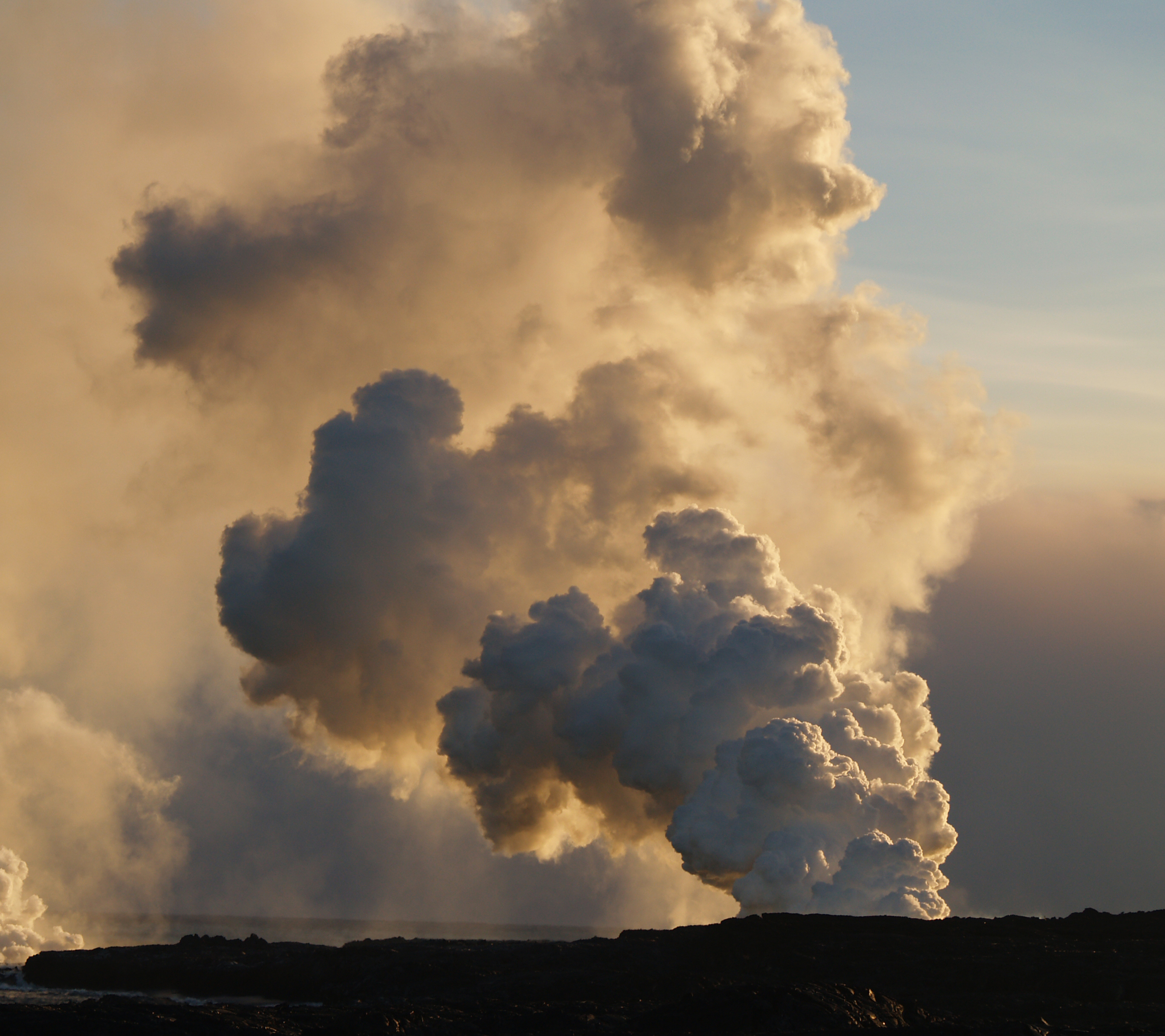
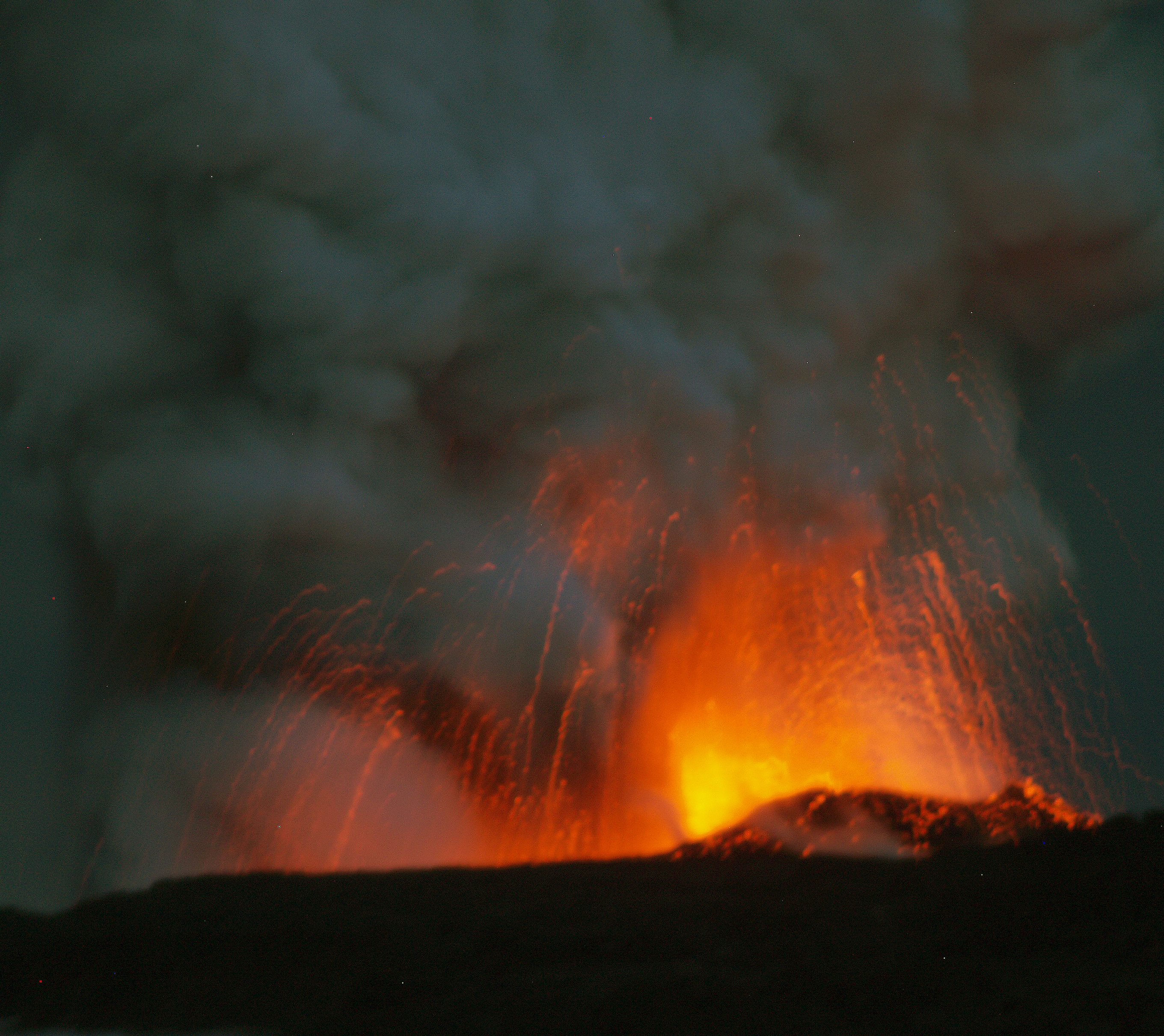
At Kīlauea's summit, the vent within Halema`uma`u Crater continues to emit elevated amounts of volcanic gas, resulting in high concentrations of sulfur dioxide downwind. Bright glow from the vent was visible at night through the past week. A collaborative effort last week between HVO and UH-Manoa scientists, using a sophisticated optical remote-sensing technology called LIDAR (Light Detection and Ranging), has measured the lava surface to be about 205 m (675 feet) below the floor of Halema`uma`u Crater.

No earthquakes beneath Hawai`i Island were reported felt this past week.

For more information on traveling to Hawaii in general and exploring the Big Island's volcanoes in particular, please also visit www.tourguidehawaii.com and www.lovingthebigisland.wordpress.com.

Tuesday, May 12, 2009

Volcano Watch: How do recent earthquakes fit into the Kilauea puzzle?

Reprinted from here.

How do recent earthquakes fit into the Kilauea puzzle?

Hawaii earthquakes: USGS Illustration, reprinted from http://hvo.wr.usgs.gov/volcanowatch/2009/09_04_23.html.

During the past two weeks, two noteworthy earthquakes struck Kīlauea Volcano’s south flank. While the south flank is among the most seismically active areas in the U. S., the vast majority of earthquakes beneath it are too small to be of general interest. At the same time, each earthquake beneath the volcano represents a piece of a very complex puzzle that we continually watch and study.

The earthquakes on April 14 (magnitude 5.0) and April 21 (magnitude 4.2) occurred at depths of roughly 9 km (5.5 miles) below the Earth’s surface in regions adjacent to Kīlauea’s east rift zone. These earthquakes gently punctuated the steady, southeastward motions of Kīlauea’s south flank. They are noteworthy because they were widely felt across Hawai`i Island (see http://earthquake.usgs.gov/eqcenter/dyfi/).

Parts of the active fault system responsible for the earthquakes are visible as the spectacular scarps that line Hawai`i’s southeast coast within Hawai`i Volcanoes National Park. A major part of the system—a fault representing the decollement, or detachment surface, between the ancient oceanic crust and the volcanic “pile” built up from repeated volcanic eruption and intrusion—becomes most apparent in larger earthquakes, as on April 14 or two of Hawai`i’s larger earthquakes in 1989 (magnitude 6.1) and 1975 (magnitude 7.2).

With capabilities afforded by continuous GPS monitoring, we measure considerable movement of Kīlauea’s south flank that occurs as steady or stable motion. Large in a geophysical context, the movements occur at rates of several inches (centimeters) per year. At a conceptual level, it is reasonable to view the decollement as a through-going and somewhat uniform fault beneath the flank.

The south flank fault system is more complex, however, when seen from the perspective of earthquake distributions. There are some regions of the south flank that are surprisingly devoid of earthquake activity. Looking back through the Hawaiian Volcano Observatory’s record of seismicity, patterns of south flank earthquake hypocenters, or computed locations, also display a general level of clustering.

While they are all related to the decollement, April 2009’s two earthquakes and the 1989 and 1975 earthquakes each occurred in distinctly separate south flank clusters. The magnitude-5.0 earthquake on April 14 occurred in one of the south flank’s western earthquake clusters. The magnitude-4.2 earthquake on April 21 occurred about 10 km (6 miles) to the east of that cluster. The 1989 earthquake was located a few kilometers (miles) east of the April 21 hypocenter, and the 1975 earthquake was about 8 km (5 miles) east of the 1989 hypocenter.

Interestingly, between the two clusters containing the April 2009 earthquakes lies a section of the south flank decollement system that has produced thousands of small earthquakes, but not a single magnitude 4 or larger earthquake since 1970. In comparison, during that same time interval, the April 14 magnitude-5.0 cluster has produced 30 such earthquakes, and the April 21 magnitude-4.2 cluster has produced 45 such earthquakes.

The earthquake clustering reflects variation in fault properties and fault structure along the decollement. Variation of earthquake behaviors within and among different clusters reflects additional complexity associated with movement of the south flank. In addition to understanding the fault properties and structures, we are striving to learn more about the forces resulting from magma residing in the rift zones and the frictional resistance along the active faults.

Each new south flank earthquake, especially if large enough to be felt, reprises questions of Kīlauea’s next possible magnitude-7 south flank earthquake. While we lack clear-cut answers to some of those questions, each earthquake compels us to look more closely and provides new information to fit into the Kīlauea puzzle.

Activity update

The Waikupanaha and Kupapa`u ocean entries remain active, with small littoral explosions common at the Kupapa`u entry over the past week. Surface flows inland from Kupapa`u remain active along the eastern boundary of Hawai`i Volcanoes National Park.

At Kīlauea's summit, the vent within Halema`uma`u Crater continues to emit elevated amounts of sulfur dioxide gas, resulting in high concentrations of sulfur dioxide downwind. Variable glow and vent noises over the past week suggest that lava is still present at shallow levels below the floor of Halema`uma`u crater.

A magnitude-4.2 earthquake at 4:58 p.m. H.s.t. on Tuesday, April 21, was located beneath Kīlauea’s south flank, about 44 km (27 miles) south of Hilo and at a depth of 9.2 km (5.7 miles). The earthquake caused no significant changes to Kīlauea's ongoing eruptions. More than 200 people reported feeling it (http://earthquake.usgs.gov/eqcenter/dyfi/events/hv/00033612/us/index.html).

Visit our Web site (http://hvo.wr.usgs.gov/volcanowatch/2009/09_04_23.html) for detailed Kīlauea and Mauna Loa activity updates, recent volcano photos, recent earthquakes, and more; call (808) 967-8862 for a Kīlauea summary; email questions to askHVO@usgs.gov.

For more information on traveling to Hawaii in general and touring the Big Island in particular, please also visit www.tourguidehawaii.com and www.lovingthebigisland.wordpress.com.

Sunday, March 15, 2009

Eruption Update: Why all the fuss about Mauna Loa this month?

Reprinted from here.

Why all the fuss about Mauna Loa this month?

 The Mauna Loa 1984 summit eruption.
The Mauna Loa 1984 summit eruption (USGS Photo).

As noted in Volcano Watch a few weeks ago, this month marks the 25th anniversary of Mauna Loa's most recent eruption—a 22-day event that began on March 25, 1984. The article also mentioned a series of public programs that will be conducted in recognition of this anniversary.

Mauna Loa has been quiet for a quarter of a century, and considering the current lack of shallow seismicity that typically precedes volcanic activity by months or years, it is not expected to erupt any time soon. So, why all the fuss about this volcano?

A look at Mauna Loa's eruption frequency over the past 2,000 years shows that it has erupted, on average, once every 10 years. The volcano's short-term average is even more remarkable. Between 1843 and 1950, Mauna Loa erupted every 4 to 7 years. Based on this eruption history, you could easily conclude that the volcano is overdue for its next eruption.

During the 166 years that Mauna Loa's activity has been documented in writing, there's only one other time when the volcano remained quiet for 25 years—the period between its June 1, 1950, and July 5, 1975, eruptions. Mauna Loa's repose since 1984 will soon match that record.

A third of Hawai`i Island's current population was not yet born in 1984. There's also been an influx of malihini (newcomers) who moved to the island after Mauna Loa erupted. Given these two facts, a significant number of island residents may not be aware that Mauna Loa is an active volcano.

Even people who witnessed the 1984 eruption may not know—or remember—the full potential of volcanic hazards posed by Mauna Loa. A lot can be forgotten in 25 years.

The silver anniversary of Mauna Loa's last eruption affords an ideal occasion to remind us all of these concerns. Thus, the Hawaiian Volcano Observatory (HVO) is planning a series of public programs about past, present, and future activity on the world's largest volcano.

Two talks will be presented as After Dark in the Park programs in Hawai`i Volcanoes National Park. On Tuesday, March 17, HVO geologist Frank Trusdell, who has been mapping and studying Mauna Loa for nearly two decades, will speak about the volcano's eruptive history and current status. On Tuesday, March 24, Jack Lockwood, a former HVO volcanologist, will describe events leading up to, and during, Mauna Loa's 1984 eruption.

Both talks will be in the Kilauea Visitor Center auditorium, starting at 7:00 p.m. For more information, call (808) 985-6011 or go to the Park Web site (http://www.nps.gov/havo/planyourvisit/events_adip.htm).

HVO will also provide outreach programs in three communities around the island in collaboration with the University of Hawai`i at Hilo's Center for the Study of Active Volcanoes, Hawai`i County Civil Defense, and Hawai`i Volcanoes National Park.

These community programs will begin with a brief introductory presentation, followed by an informal "talk story" session, during which you can meet and interact with scientists, public safety officials, and park rangers. The programs are designed so that you can come and go at your leisure to talk story, but to hear the introductory presentation, you should arrive at the starting time.

Two programs are scheduled for Saturday, March 28—from 9:00 to 11:00 a.m. at UH-Hilo in UCB 100/127, and from 3:00 to 5:00 p.m. at St. Jude's Church in Ocean View. On Saturday, April 4, a program will be held at the Konawaena Elementary School cafeteria in Kealakekua from 10:00 a.m. to 12:00 p.m.

Displays set up for the talk story session will address frequently asked questions about Mauna Loa—such as, "Will it erupt soon?"—but you are welcome to bring any and all questions that you'd like to ask about the volcano. Children can engage in activities and demonstrations set up just for them.

Mauna Loa will erupt again—and chances are good that it will happen during your lifetime-so you are encouraged to attend one of the community programs. There's no better time than now to educate yourself about the massive volcano in your backyard.

Activity update

Kīlauea Volcano continues to be active. A vent in Halema`uma`u Crater is emitting elevated amounts of sulfur dioxide gas and producing small amounts of ash. Resulting high concentrations of sulfur dioxide in downwind air have closed the south part of Kīlauea caldera and produced occasional air quality alerts in more distant areas, such as Pahala and communities adjacent to Hawai`i Volcanoes National Park, during kona wind periods. Using a thermal camera, a small, puffing cone, varying in shape and size over the past week, has been visible about 100 yards below the vent rim.

Pu`u `Ō`ō also continues to produce significant amounts of sulfur dioxide. Trade winds tend to pool these emissions along the West Hawai`i coast, while Kona winds blow these emissions into communities to the north, such as Mountain View, Volcano, and Hilo.

A deflation/inflation (DI) event at Kilauea's summit early in the week caused no reported disruption in the supply of lava erupting from the Thanksgiving Eve Breakout (TEB) vent at the eastern base of Pu`u `O`o. Lava continues to enter the ocean at Waikupanaha and is rebuilding the delta there, which collapsed last Saturday (February 28). Thursday (March 5) marked the one-year anniversary of the start of the Waikupanaha ocean entry. Lava was also active on the coastal plain a few hundred yards from the ocean near Waha'ula in the National Park.

Be aware that active and recently inactive lava deltas can collapse at any time, potentially generating large explosions. This may be especially true during times of rapidly changing lava supply conditions. The Waikupanaha delta has collapsed several times in the past year, with at least four of the collapses resulting in rock blasts. These blasts have tossed television-sized rocks up onto the sea-cliff and have thrown fist-sized rocks more than 275 yards inland. It is unclear whether the February 28 collapse was accompanied by an explosion.

Do not approach the ocean entry or venture onto lava deltas. Even the intervening beaches are susceptible to large waves generated during delta collapse; avoid these beaches. In addition, steam plumes rising from ocean entries are highly acidic and laced with glass particles. Call Hawai`i County Civil Defense at 961-8093 for viewing hours.

Mauna Loa is not erupting. Three earthquakes were located beneath the summit this past week. Continuing extension between locations spanning the summit indicates slow inflation of the volcano, combined with slow eastward slippage of its east flank.

Four earthquakes beneath Hawai`i Island were reported felt within the past week. A magnitude-2.2 earthquake occurred at 12:06 p.m., H.s.t, on Thursday, February 26, 2009, and was located 12 km (8 miles) north of Kailua at a depth of 36 km (22 miles). A magnitude-2.2 earthquake occurred at 4:59 p.m. on Saturday, February 28, and was located 9 km (6 miles) west of Kailua at a depth of 11 km (7 miles). A magnitude-3.0 earthquake occurred at 9:20 a.m. on Wednesday, March 4, and was located 26 km (16 miles) southwest of Kailua at a depth of 38 km (24 miles). A magnitude-2.9 earthquake occurred at 8:25 a.m. on Thursday, March 5, and was located 3 km (2 miles) northeast of Pu`ulena Crater at very shallow depth.

Visit our Web site (http://hvo.wr.usgs.gov) for daily Kīlauea eruption updates, a summary of volcanic events over the past year, and nearly real-time Hawai`i earthquake information. Kīlauea daily update summaries are also available by phone at (808) 967-8862. Questions can be emailed to askHVO@usgs.gov. skip past bottom navigational bar

For more information on touring Hawaii in general and seeing the volcanoes of the Big Island in particular, please visit www.tourguidehawaii.com and www.lovingthebigisland.wordpress.com.

Monday, February 23, 2009

Volcano Update: Quiescence in 1913 is similar to 2008 events

Reprinted from here.

The Eruption of Halema'uma'u as seen from Steaming Bluff, HVNP, August, 2008: Photo by Donald MacGowan

Quiescence in 1913 is similar to 2008 events

In most sciences, processes are investigated by identifying the factors that affect them and varying each factor, in turn, to determine its contribution. In field geology, this is difficult; instead, we compare and contrast events or locations to learn more about the processes. At Kīlauea, there is a long, well-documented history with which to compare and contrast current activities. Summit events at Kīlauea over the last year have been unique since 1924, but bear interesting similarities to lulls in lava lake activity prior to 1924.

It is well known that, until 1924, there was a nearly continuous lake of lava in Halema`uma`u Crater, which was less than half the diameter it is today. But "nearly continuous" means there were periods when the lava lake disappeared. Mid-1913 to late 1914 was one of those periods when the crater was filled with fume, but not lava. Fortunately, regular Hawaiian Volcano Observatory (HVO) reports described this lull.

In 1913, HVO was located where the Volcano House hotel is today. Lacking direct views into Halema`uma`u Crater, observers noted sounds and characteristics of the fume coming from the pit to describe its behavior.

Reports of glow were infrequent, but descriptions of noises from the crate-blowing, coughing, booming, hissing, rumbling, grumbling, puffing, and breathing-were common. Rock slides, which were frequent and audible, sometimes produced dust clouds.

"During the last three months the only marks of activity which have fluctuated have been noises of blowing and rumbling, greater or less suffocating quality to the fumes when breathed, and very rare glimpses of flame seen two or three times at night." (HVO report, August 18, 1913).

Through September, the noises increased in intensity, and some glow was observed. Pele's hair was frequently found downwind of the crater and, when the fumes cleared, glimpses of a lava vent deep in Halema`uma`u Crater could be seen.

By October 20, 1913, Halema`uma`u Crater was considered to be in a minor eruptive phase. The crater was emitting much greater volumes of fume than in August. Sounds resembling "swashing liquid" suggest the continued existence of a lava lake, even when it was obscured by fume. A glow-lit fume cloud was a frequent sight over the crater at night.

Activity decreased through the end of 1913, and Halema`uma`u finished the year in a "semi-dormant" state, with a crater shaped like a huge funnel about 200 m (600 ft) deep and a thickly crusted lava pool in its bottom. Vigorous lava lake activity did not resume until late 1914.

Jump ahead to 2008. HVO reports have been describing many of the same characteristics. Few views of a lava pond have been recorded, but blowing and booming sounds, rock falls, and dust plumes have been common. Explosions were common in much of 2008, and some were energetic enough to erupt material to the crater rim.

The 1913-14 lull in activity and the currently elevated summit activity both result from lava being at similar shallow depths below Halema`uma`u Crater. In the early part of 1913, lava dropped to that level. In early 2008, magma rose to a similar depth.

The 2008 activity produced small amounts of tephra, often including Pele's hair. The 1913-14 lull also produced notable amounts of Pele's hair, but production of other tephra was not recorded.

Throughout both events, progress is highly variable. The overall rise of lava in the crater during 1913 and 1914 was halting, with episodes of rise repeatedly cut short with episodes of subsidence. Similarly, the 2008 activity changes several times a week, with lava interpreted to be rising and falling within the conduit below the vent.

In both cases, shallow magma produced elevated SO2 emissions and glow from the vent. "Fumes continue to pour out without abatement" (HVO report, February 4, 1914). Observers commonly described the fume as being difficult to breathe in 1913. Respiratory protection is required to work in the fume emitted today but probably wasn't necessary in earlier years.

HVO continues to monitor Kīlauea's activities and we hope to learn more by comparing recent events with past volcanic activity.

Activity update

Kīlauea Volcano continues to be active. A vent in Halema`uma`u Crater is emitting elevated amounts of sulfur dioxide gas and producing small amounts of ash. Resulting high concentrations of sulfur dioxide in downwind air have closed the south part of Kīlauea caldera and produced occasional air quality alerts in more distant areas, such as Pahala and communities adjacent to Hawai`i Volcanoes National Park, during kona wind periods. A collapse deep within the vent on Wednesday, February 4 produced a robust brown plume and appeared to reopen the conduit, filled with rubble since early December. Views inside the vent the next day with a thermal camera showed a small, crusted lava pond more than 100 yards below the vent rim.

Pu`u `Ō`ō continues to produce sulfur dioxide at even higher rates than the vent in Halema`uma`u Crater. Trade winds tend to pool these emissions along the West Hawai`i coast, while Kona winds blow these emissions into communities to the north, such as Mountain View, Volcano, and Hilo.

Lava erupting from the Thanksgiving Eve Breakout (TEB) vent at the eastern base of Pu`u `Ō`ō continues to flow to the ocean at Waikupanaha through a well-established lava tube. Breakouts from a western branch of the lava tube were active on the coastal plain near the National Park boundary early in the week and also continued to feed the small ocean entry near Waha`ula. A deflation-inflation cycle beginning February 3 led to a short-term reduction in lava supply to the flow field. Surface flows and ocean entries were inactive on Thursday, February 5, and will probably resume shortly.

Be aware that active lava deltas can collapse at any time, potentially generating large explosions. This may be especially true during times of rapidly changing lava supply conditions. The Waikupanaha delta has collapsed many times over the last several months, with three of the collapses resulting in rock blasts that tossed television-sized rocks up onto the sea-cliff and threw fist-sized rocks more than 200 yards inland.

Do not approach the ocean entry or venture onto the lava deltas. Even the intervening beaches are susceptible to large waves generated during delta collapse; avoid these beaches. In addition, steam plumes rising from ocean entries are highly acidic and laced with glass particles. Call Hawai`i County Civil Defense at 961-8093 for viewing hours.

Mauna Loa is not erupting. No earthquakes were located beneath the summit this past week. Continuing extension between locations spanning the summit indicates slow inflation of the volcano, combined with slow eastward slippage of its east flank.

Three earthquakes beneath Hawai`i Island were reported felt within the past week. A magnitude-3.2 earthquake occurred at 3:37 p.m., H.s.t., on Friday, January 30, 2009, and was located 2 km (1 mile) east of Pahala at a depth of 10 km (6 miles). A magnitude-3.4 and a magnitude-3.5 earthquake occurred at 7:12 and 7:17 p.m., respectively, on the same Friday and were located 7 km (4 miles) west of Kalapana at a depth of 9 km (6 miles).

Visit our Web site (http://hvo.wr.usgs.gov) for daily Kīlauea eruption updates, a summary of volcanic events over the past year, and nearly real-time Hawai`i earthquake information. Kīlauea daily update summaries are also available by phone at (808) 967-8862. Questions can be emailed to askHVO@usgs.gov.

For more information on traveling to Hawaii in general and seeing the volcanoes of the Big Island in particular, please visit www.tourguidehawaii.com and www.tourguidehawaii.blogspot.com.

Thursday, October 30, 2008

Kilauea Eruption Update!

Reprinted from here.


Lava Flowing Down the Pali to the Waikupanaha Ocean Entry, Hawaii Volcanoes National Park

KILAUEA VOLCANO (CAVW#1302-01-)
19.42°N 155.29°W, Summit Elevation 4091 ft (1247 m)
Volcano Alert Level: WATCH
Aviation Color Code: ORANGE

This report on the status of Kilauea volcanic activity, in addition to maps, photos, and webcam images (available using the menu bar above), was prepared by the USGS Hawaiian Volcano Observatory (HVO). Hawai`i Volcanoes National Park status can be found at http://www.nps.gov/havo/ or 985-6000. Hawai`i County Viewing Area status can be found at 961-8093.

Activity Summary for last 24 hours: The final inflation portion of a DI tilt event is in progress. Sulfur dioxide emission rates from the Halema`uma`u and the Pu`u `O`o vents remain high although the emissions from Pu`u `O`o have been decreasing since August. Tephra production from the Halema`uma`u vent remains small. At the east rift eruption site, the flow of lava has paused.

Last 24 hours at Kilauea summit: Weak winds produced poor air quality during most of the last 24 hours. Vent glow was too weak to be recorded by the webcam overnight. This morning, winds above 300 m (1,000 ft) are moving the gas plume to the southwest; winds closer to the ground are weaker resulting in voggy air. GOES-WEST imagery shows the plume moving southwest inland of the coast.

Small amounts of tephra continued to be produced, the collections continue to consistent mostly of glassy spatter. In addition to sounds resembling distant surf, rock falls and rolls could also be made out from the vent.

Sulfur dioxide emission rates remain elevated and variable. The most recent average measurement was 500 tonnes/day on October 24, compared to the 2003-2007 average rate of 140 tonnes/day.

The network of tiltmeters within Kilauea caldera recorded the inflation portion of the ongoing DI tilt event starting at about 2 am. The GPS receiver networks (less sensitive than tiltmeters) recorded small changes but no significant extension or contraction over the past two weeks.

Seismic activity continued to be focused on the south caldera; tremor levels dropped with the start of inflation. A total of 17 earthquakes were located beneath Kilauea or nearby, including 5 beneath the south caldera and none on south flank faults, with the number of RB2S2BL earthquakes increasing to around 50/day.

Last 24 hours at the middle east rift zone vents and flow field: Magma continues to degas through Pu`u `O`o Crater. The most recent sulfur dioxide measurement of 1,100 tonnes/day on October 24 is below the 2005-2007 average of about 2,000 tonnes/day for this vent; Pu`u `O`o emission rates have been slowly declining since early August. No incandescence was observed within the crater overnight.

Pu`u `O`o continues to deflate/collapse. The tiltmeter on the north side of Pu`u `O`o recorded no change in tilt since noon yesterday; the Pu`u `O`o tiltmeter has not yet responded to the DI inflation in progress at the summit. GPS stations spanning the crater (less sensitive than tiltmeters) recorded weak contraction across the crater. Seismic tremor levels near Pu`u `O`o and the TEB vent remain at low values and still haven't responded to the ongoing DI tilt event.

Lava from the TEB vent and the rootless shield complex has paused. The ocean entry plume was very small and only intermittently active yesterday through last night. Incandescence was seen high on the pali above Royal Gardens and from the TEB vent overnight and this morning. GOES-WEST thermal anomalies continued to weaken overnight suggesting that surface flows are no longer active. This morning, CD officials report no active ocean entry.

Aerial View of the Lava Flowing Into the Ocean; Hawaii Volcanoes National Park

For more information on visiting Hawaii in general or touring the Big Island in particular, go to www.tourguidehawaii.com and www.lovingthebigisland.wordpress.com. For video of the eruptions in Hawaii volcanoes national Park, go here, here and here.

Tuesday, September 16, 2008

Sloshing lava lake viewed within Halema'uma'u vent

Reprinted from here.

This near-vertical view reveals a vigorously bubbling lava surface below the rim of the vent within Halema`uma`u crater. Continuous spattering was casting globs of lava across the lake surface and onto the conduit walls.

For the first time since the new vent opened in Halema'uma'u Crater on March 19, HVO scientists in a helicopter hovering over the crater were able to see the surface of a sloshing 50 m (160 ft) diameter lava lake about 100 m (330 ft) below the vent rim. HVO scientists have speculated that a lava pond existed a few hundred meters below the vent, but have not been able to get visual confirmation until this morning.

A second viewing early this afternoon revealed a roiling pond with multiple bursting bubbles changing into a central upwelling circulation pattern. The lake level dropped slightly before the cycle restarted. This behavior has been witnessed before, most recently in Pu'u 'O'o vents and the July 21 lava ponds on Kilauea's east rift zone, and is known as "gas pistoning." One model explains pistoning as small gas bubbles coalescing into larger bubbles beneath a crust on a lava pond, rising to the surface, and then bursting. The released pulse of hot gas carries rock dust from the collapsing vent walls, bits of the lava lake crust, and small amounts of spatter.

The Halema'uma'u vent has produced six significant explosive eruptions in the past 5.5 months, most recently on September 2, 2008 at 8:13 p.m. H.s.t., during which noteworthy amounts of fresh lava spatter and lithic material (rock fragments and dust) were ejected on to the crater rim. Just prior to this event, incandescence from the vent was almost nonexistent except for brief pulses of glow.

Nearly eight hours later, Kilauea's summit abruptly inflated, signaling the end of 39 hours of deflation. Summit deflation-inflation (DI) events have been observed at least 20 times since the Halema'uma'u vent opened. Each DI event has been interpreted as the fall and subsequent rise in magma levels beneath the summit.

Less than 8 hours after inflation started, episodic tremor bursts began which are visible at night as pulses of bright incandescence every 5-6 minutes. Episodic tremor bursts have been a nearly constant feature of the Halema'uma'u vent over the past few months and were one of the early pieces of evidence pointing toward a gas pistoning source.

This unusually bright incandescence over the past two nights and the volume of material erupted on September 2 are consistent with a lava surface at relatively shallow depths beneath the vent. Molten lava is not directly visible from the Jaggar Museum overlook, but that vantage point provides excellent views of the glowing vent at night.

For more information on traveling to Hawaii in general and visiting the Big Island in particular, visit www.tourguidehawaii.com and www.lovingthebigisland.wordpress.com.

Friday, August 8, 2008

Weekly Volcano Update!

Reprinted from here.

For video of the eruptive activity, go here.


Photo By Donnie MacGowan
Explosion cloud of littoral explosion, BIg ISland, Hawaii.  Photo by Donad B. MacGowan

For video on hiking to see the flowing lava, please go here.

Halema`uma`u appears laid back but . . .


Photo by Dr. Donald B. MacGowanPhoto by Dr. Donald B. MacGowan

In contrast to the spectacular incandescent explosions and springtime spatter showers at the Halema`uma`u Overlook in March and April, the eruptive vent at the summit of Kīlauea Volcano seems to have adopted a laid-back summer attitude, with a steady plume rising from a dull glowing hole at the base of the southeast wall of the crater.

The 40-meter-wide (120-feet-wide) opening of this still-fuming chimney provides a partial view into the bright abyss beneath the crater wall that broadcasts the clatter of frequent wall-rock collapses and extends to depths within earshot of splashing and sloshing magma.

During the spring 2008 eruptive period, this hot, gargling vent coughed up an interesting mélange of "pyroclasts" - rocks, dust, and gravel from the collapsed crater floor and conduit walls, mixed with a small portion of bombs, spatter, Pele's hair, and tears that were molten or near-molten when erupted. (The latter fragments are referred to as "juveniles" in volcano parlance because they are first-timers at the earth's surface.)

Pyroclasts can tell us the conditions of their formation. For example, we know that the Pele's hair, tears, pumice, and glassy spatter are identical in composition to the hottest Kīlauea lavas recently erupted along the east rift zone. The composition of the gases from Pu`u `Ō `ō and Halema`uma`u are also similar to each other, showing that, after nearly 25 years of near-continuous volcanic eruption, magma pathways throughout Kīlauea's shallow volcanic edifice are full of new magma from depth.

Subtle clues as to whether the summit eruption will either cease or perhaps become ominously hazardous could be found through further study of the pyroclasts. We have found that a sordid lot of pumice-like glass fragments were, prior to their springtime expulsion from the vent, baked in a fumarole on the sides of the conduit, in a fashion akin to creosote build-up in a stove pipe. Collectively these and similarly recycled material are evidence for subterranean build-up of debris-talus and spatter deposits within the eruption conduit.

Close examination of spatter and large lava droplets (lapilli) reveals dense, relatively cool crystal-mush clots contained within hotter bubbly lava. This is a clear sign that cooler magma was disrupted by hot, effervescing magma prior to eruption.

For the past two months, there has been a scarcity of unquestionably fresh glassy material from Halema`uma`u. The plume is only lightly ash-laden, and newly formed glassy particles that are presently being erupted cannot be readily distinguished from previously erupted material plucked off the ground by strong winds.

Steady summit gas emissions and the small quantity of Pele's hair and tears being erupted indicates that summit magma may have temporarily receded or may no longer be as well-connected to the atmosphere. The Halema`uma`u chimney may be partially sealed by a mix of collapsed wall rocks and choked by recent deposits of lava spatter, pumice, bombs and ash. If magma stops moving within the conduit, it will cool and thicken into a partially molten plug resembling the springtime chunks of relatively cool crystal-mush.

The longer that plug cools, the more likely this recent period of summit activity will slowly come to a close. It is most likely that a balance will persist. A lava plug beneath a subterranean pile of talus and spatter would provide little resistance but plenty of explosion fodder for the next time fresh, hot magma rises beneath the Halema'uma'u Overlook and gas pressure builds up!

Activity update

Kīlauea Volcano continues to be active. A vent in Halema`uma`u Crater is erupting elevated amounts of sulfur dioxide gas and very small amounts of ash. Resulting high concentrations of sulfur dioxide in downwind air have closed the south part of Kīlauea caldera and produced occasional air quality alerts in more distant areas, such as Pahala and communities adjacent to Hawai`i Volcanoes National Park, during kona wind periods.

Pu`u `Ō`ō continues to produce sulfur dioxide at even higher rates than the vent in Halema`uma`u Crater. Trade winds tend to pool these emissions along the West Hawai`i coast. Kona winds blow these emissions into communities to the north, such as Mountain View, Volcano, and Hilo. Incandescence continues to be observed at night inside Pu`u `Ō`ō and suggests minor activity from vents within the crater. There was a small explosion within the crater that deposited small rocks around the east rim of the cone; seismic and tilt data suggest that this occurred on the evening of July 26.

Lava continues to erupt from fissure D of the July 21, 2007, eruption but no breakouts have been observed in the past week on or above the pali. Lava, however, continues to flow through what remains of Royal Gardens and across the coastal plain to the ocean in a well-established lava tube, active now for several months. Minor-to-moderate explosive activity continues at the Waikupanaha ocean entry, and there have been a few new breakouts immediately inland from the delta. A small (2.5 acre) delta collapse that probably occurred between 5 and 6 a.m. on Wednesday, July 30, scattered large rocks up to 100 meters (yards) inland from the collapse scar.

Be aware that lava deltas could collapse at any time, potentially generating large explosions, as happened this past week. This may be especially true during times of rapidly changing lava supply conditions, as have been seen lately. Do not venture onto the lava deltas. Even the intervening beaches are susceptible to large waves generated during delta collapse; avoid these beaches. In addition, steam plumes rising from ocean entries are highly acidic and laced with glass particles. Check Civil Defense Web site (http://www.lavainfo.us) or call 961-8093 for viewing hours.

Mauna Loa is not erupting. Three earthquakes were located beneath the summit this past week. Continuing extension between locations spanning the summit indicates slow inflation of the volcano.

Two earthquakes beneath Hawai`i Island were reported felt within the past week. A magnitude-2.4 earthquake occurred at 00:55 a.m. on Saturday, July 26, 2008, H.s.t., and was located 2 km (1 mile) southwest of Kilauea summit at a depth of 2 km (1 mile). A magnitude-2.7 earthquake occurred at 12:20 p.m. on Monday, July 28, and was located 7 km (4 miles) southeast of Ho`okena at a depth of 14 km (9 miles).

Visit our Web site (http://hvo.wr.usgs.gov) for daily Kīlauea eruption updates, a summary of volcanic events over the past year, and nearly real-time Hawai`i earthquake information. Kīlauea daily update summaries are also available by phone at (808) 967-8862. Questions can be emailed to askHVO@usgs.gov.

For more information on visiting Hawaii in general, or touring the Big Island in particular, please visit www.tourguidehawaii.com and www.lovingthebigisland.wordpress.com.

Thursday, July 24, 2008

Weekly Volcano Update: Kilauea and Mauna Loa on the Big Island of Hawaii!

Reprinted from here.

An exciting end to June at Kīlauea

A littoral explosion at dusk. Explosions such as this have been common throughout the last several weeks at the Waikupanaha entry.  June 29, 2008.
A littoral explosion at dusk. Explosions such as this have been common throughout the last several weeks at the Waikupanaha entry. June 29, 2008.
One of the most surprising aspects of the current summit eruption at Kīlauea Volcano, which started in March of this year, is that there has been almost no change in surface deformation trends. Past summit eruptions have been accompanied by rapid inflation prior to the start of an eruption, followed by equally rapid deflation. During the present period, however, the summit of Kīlauea has shown no change from the trend of gradual deflation since July 21, 2007, when the eruption site migrated about 2 km (1.5 miles) downrift from Pu`u `Ō`ō. No change, that is, until just a few weeks ago.

On June 24, tiltmeters at Kīlauea's summit and at Pu`u `Ō`ō began showing inflation-the first time sustained inflation has occurred at both sites since July 21, 2007.

In addition to the change in ground deformation, other types of monitoring data indicated a shift in the style of eruptive activity. Throughout early and mid-June, the intensity of the glow from the summit vent had decreased, relative to the strong glow seen in April and May. In late June, however, the summit vent began glowing brighter.

The intensity of the glow, in fact, correlates with bursts of seismic tremor that occur every few minutes, with more glow during the tremor bursts and less between bursts. These tremor bursts also increased in magnitude and frequency in late June. The correlation between tremor and glow led HVO scientists to infer that gas bubbles were bursting through a crusted lava surface beneath the Halema`uma`u vent. Increases in the strength of both the glow and tremor bursts may have indicated rising of the lava surface.

Another late June change in activity was the occurrence of surface lava flows from the east rift zone for the first time in several weeks. Lava broke out of the tube system, both on the east rift zone and above the Royal Gardens subdivision. At the same time, enough lava was being transported through the tube system to result in spectacular littoral explosions at the ocean entry during early July. All of these signs point to a lava tube system that was full to the point of overflowing.

Taken together, this evidence suggests that Kīlauea was engorged with magma, starting in late June. Increased magma in the caldera and east rift areas resulted in inflation of the summit and Pu`u `Ō`ō and, possibly, rising of the lava column in the Hamema`uma`u vent. Magma was also being delivered to the eruption site at a greater rate than normal, resulting in the numerous surface lava flows.

What might be the result of such activity? It is conceivable that more magma within Kīlauea's plumbing system could result in a change in the east rift zone eruption site, much like that which occurred in mid-2007. Lava might even erupt from the Hamema`uma`u vent, forming a lava lake at the summit.

Of course, Pele seems to enjoy keeping us on our toes. On July 1, deformation at Pu`u `Ō`ō stabilized, and the summit began to deflate, suggesting that even more magma was being fed from the summit to the east rift zone eruption site. Lava flow activity on the east rift zone and above Royal Gardens continued to increase. On July 7, a spectacular fountain formed near the TEB (Thanksgiving Eve Breakout) vent, possibly due to partial blocking of the lava tube system. At the summit, however, the intensity of glow from the Halema`uma`u vent has waned, suggesting that, at least for the moment, volcanic activity will focus on the east rift zone.

The weeks since June 24 have been a significant departure from "normal" trends of deformation during the current summit eruption, and also saw the most surface lava flow activity in several months. What caused Kīlauea to suddenly fill with magma and, just as suddenly, begin to drain?

One explanation is that the lava supply to Kīlauea fluctuates on timescales of days to weeks, causing rapid changes in surface deformation and eruptive activity. Although the causes of these fluctuations are not clear, the variations obviously are an important control on the activity we observe at the surface.

HVO will remain vigilant for future changes in the amount of magma coursing through Kīlauea's veins. Such activity should be easy to detect, given the excellent seismic, deformation, gas, and visual monitoring of the volcano, both at the summit and along the east rift zone. We invite you to follow along by checking HVO's Webcams, data plots, and daily activity updates available at http://hvo.wr.usgs.gov.

Activity update

Kīlauea Volcano continues to be active. A vent in Halema`uma`u Crater is erupting elevated amounts of sulfur dioxide gas and very small amounts of ash. Resulting high concentrations of sulfur dioxide in downwind air have closed the south part of Kīlauea caldera and produced occasional air quality alerts in more distant areas, such as Pahala and communities adjacent to Hawai`i Volcanoes National Park, during kona wind periods.

Pu`u `Ō`ō continues to produce sulfur dioxide at even higher rates than the vent in Halema`uma`u Crater. Trade winds tend to pool these emissions along the West Hawai`i coast. Kona winds blow these emissions into communities to the north, such as Mountain View, Volcano and Hilo. As of this writing (July 10), the gas vent below the east rim of Pu`u `Ō`ō was spattering weakly, with some spatter reaching the crater rim. At least two other vents within the Pu`u `Ō`ō crater were also spattering. The one near the western end of the crater was spattering vigorously and sporadically, feeding a small lava pond on the crater floor.

Lava continues to erupt from fissure D of the July 21, 2007, eruption and is supplying several breakouts along the 2007 Thanksgiving Eve Breakout (TEB) tube system above the pali and near the top of Royal Gardens. Activity was quite vigorous early in the week, feeding multiple breakouts, including a 10-15-m-high lava fountain. By July 10, activity had diminished, with only sparse surface flows observed.

Lava also continues to flow through what remains of Royal Gardens and across the coastal plain to the ocean in a well-established lava tube active now for several months. When the surface activity intensified upslope early in the week, the Waikupanaha ocean entry diminished significantly and appeared nearly inactive. Full vigor had returned by July 10, with small explosions and a large plume.

Be aware that lava deltas could collapse at any time, potentially generating large explosions. This may be especially true during times of rapidly changing lava supply conditions, as have been seen lately. Do not venture onto the lava deltas. Even the intervening beaches are susceptible to large waves generated during delta collapse; avoid these beaches. In addition, steam plumes rising from ocean entries are highly acidic and laced with glass particles. Check Civil Defense Web site (http://www.lavainfo.us) or call 961-8093 for viewing hours.

Mauna Loa is not erupting. Two earthquakes were located beneath the summit this past week. Continuing extension between locations spanning the summit indicates slow inflation of the volcano.

Four earthquakes beneath Hawai`i Island were reported felt within the past week; all occurred on Tuesday, July 8, 2008. A magnitude-2.7 earthquake occurred at 00:06 a.m., H.s.t., and was located 2 km (1 mile) southwest of Kīlauea summit at a depth of 1 km (1 mile). A magnitude-3.2 earthquake occurred at 00:38 a.m. and was located 3 km (2 miles) southwest of Kīlauea summit at a depth of 400 m (0.2 miles). A magnitude-2.8 earthquake occurred at 7:36 a.m. and was located 5 km (3 miles) northwest of Pa`auilo at a depth of 9 km (5 miles). A magnitude-1.8 earthquake occurred at 10:09 p.m. and was located 3 km (2 miles) southeast of Captain Cook at a depth of 8 km (5 miles).

Visit our Web site (http://hvo.wr.usgs.gov) for daily Kīlauea eruption updates, a summary of volcanic events over the past year, and nearly real-time Hawai`i earthquake information. Kīlauea daily update summaries are also available by phone at (808) 967-8862. Questions can be emailed to askHVO@usgs.gov.


For more information on touring Hawaii in general, or visiting the Big Island in particular, go to www.tourguidehawaii.com and here. skip past bottom navigational bar

Friday, May 30, 2008

Pele's cooking more than vog -- "precious" jewels also stewing in her cauldron


Both opague and glassy crystals are native, or pure, sulfur. The glassy crystal is about 2 mm (0.08 inches) long.
Photo by M. Sako


After the series of explosions at Halema`uma`u Crater, the overlook area appeared to be a stark, boulder-strewn field completely devoid of life. To the casual observer, little beauty could be seen in this otherworldly landscape. But on closer inspection, the field of rocks that covers Halema`uma`u reveals an array of colors - rocks blood-red and ochre, canary yellow, pinks of every hue, and a broad range of whites. These colors can appear as non-glossy lacquer, or as a brilliant glass, reflecting light. Photos don't do justice to the astonishing beauty of these rocks. But under the microscope their radiance is clearly revealed.

Some of the minerals have familiar names, like sulfur and gypsum. Others are, perhaps, more foreign, like alunite and jarosite. Individual colors usually cannot be assigned to specific minerals, because many mineral share the same, or similar, colors. Because of this, a geologist in the field uses a combination of color, shape (also known as crystal habit), and other physical characteristics to identify a mineral.

At Halema`uma`u, however, the number of minerals present is relatively small, and some generalizations based on color can be made. For example, the canary-yellow rocks are almost always composed of native sulfur. Perhaps you've seen the conspicuous yellow patches of ground in Halema`uma`u or at Sulfur Banks. Native sulfur is a very common mineral at volcanic fumaroles around the world.

The ochre, blood-red, or yellowish-red rocks are usually iron-oxide minerals, like hematite or goethite. These minerals are also very common in volcanic terrains.

The white minerals at Halema`uma`u are among the most difficult to identify, because so many different minerals may take on this color. However, most of the white-colored rocks you see there are actually the white crusts formed by a family of related minerals known as sulfate salts. Gypsum is one of these salts.

As beautiful as these Halema`uma`u minerals can be, they are of little economic value. But as the saying goes, one person's lead is another's gold. Indeed, for a geologist seeking to understand how the volcano works, these minerals are priceless jewels.

By studying volcanic systems like Kilauea, geologists have come to understand that each mineral is formed from a recipe that specifies temperature, pressure, and chemical elements as ingredients. Changes in the recipe usually form specific minerals or families of minerals in a predictable fashion.

The rocks that were ejected from Halema`uma`u during the first explosion of March 19 contained a collection of minerals that resulted from a high-temperature recipe with relatively low amounts of sulfur and water. These observations suggest that the explosion was not caused by volcanic vapor interacting with lower-temperature ground water. Thus, we believe that the mechanism which caused the March 19th explosion differed from the ground-water-driven explosions at Halema`uma`u in 1924.

More recent rocks ejected from Halema`uma`u contain minerals that suggest a similar recipe to that of the March 19th explosion, but with an interesting twist; the family of sulfate salts (of which gypsum is a member) had subtlety changed. New members have shown up; sulfate-salt minerals, such as alunite and jarosite, have been seen in the mix. Although in the same family, these minerals differ from gypsum because they require a highly acidic broth of sulfur and water. Thus, their presence indicates that, deep within the cauldron of Halema`uma`u, the stew is becoming more acidic and sulfur-rich through time.

In the history of observations at Kilauea Volcano, this eruption marks the first time that these sorts of relationships have been recorded, along with other detailed observations, such as gas chemistry and temperature measurements. As such, our understanding of these processes is rapidly evolving. So as Halema`uma`u continues to brew, we walk out on that ostensibly stark landscape in search of more of these "jewels."

We encourage readers to explore and learn more about minerals discussed in this article on line at Wikipedia (www.wikipedia.org) and WebMineral (www.webmineral.com).

Activity update

Kilauea Volcano continued to be active at two locations: a vent in Halema`uma`u Crater is erupting elevated amounts of sulfur dioxide gas and very small amounts of ash. The resulting high concentrations of sulfur dioxide in downwind air have closed the south part of Kilauea caldera and produced occasional air quality alerts in more distant areas, such as Pahala, during trade wind cycles and communities adjacent to Hawai`i Volcanoes National Park during kona wind periods. Pu`u `O`o continued to produce sulfur dioxide at even higher rates than the vent in Halema`uma`u Crater. Trade winds tend to pool these emissions along the West Hawai`i coast. Kona winds blow these emissions into communities to the north, such as Mountain View, Volcano, and Hilo.

Lava from the 2007 Thanksgiving Eve Breakout (TEB) flow, erupting from fissure D of the July 21 eruption, continues to flow through what remains of the Royal Gardens subdivision and across the coastal plain to the ocean within well-established lava tubes. Over the past week, the Waikupanaha ocean entry has produced vigorous small explosions, with ejecta fallout limited to the new delta.

The public should be aware that lava deltas could collapse at any time, potentially generating large explosions in the process. This may be especially true during times of rapidly changing lava supply conditions, as have been seen lately. Do not venture onto the lava deltas. Even the intervening beaches are susceptible to large waves that are suddenly generated during delta collapse; these beaches should be avoided. In addition, the steam plumes rising from the ocean entries are highly acidic and laced with glass particles. Check the County of Hawai`i Civil Defense website (http://www.lavainfo.us) or call 961-8903 for information on public access to the coastal plain and ocean entry.

Mauna Loa is not erupting. One earthquake was located beneath the summit. Extension between locations spanning the summit, indicating inflation, has resumed following a period of stagnation.

No earthquakes beneath Hawai`i Island were reported felt within the past week.

Visit our Web site (http://hvo.wr.usgs.gov) for daily Kilauea eruption updates and nearly real-time Hawai`i earthquake information. Kilauea daily update summaries are also available by phone at (808) 967-8862. Questions can be emailed to askHVO@usgs.gov.

For more information on visiting Hawaii in general and touring the Big Island in particular, visit here and here.

Saturday, May 3, 2008

Kilauea; Weekly Volcano Watch from the U.S. Geological Survey

Professor Jaggar would have loved this view

From the USGS Volcano Watch Site, published April 24, 2008.

Gas geochemist Jeff Sutton does a duty shift in the HVO tower keeping an eye on the Halema`uma`u vent.

Unusual, tantalizing, mesmerizing. Adrenaline-spiking, mid-life crisis(?). These words have been used in our recent Volcano Watch reports as we present our observations and describe Kilauea Volcano's behaviors related to and following the explosion that occurred at Halema`uma`u on March 19. The event has definitely been unique in our modern era of volcano watching.

It is important to recognize that the recent explosions on March 19, April 9, and April 16 are all quite small, compared to Halema`uma`u's previous explosive sequence in 1924. We also need to understand that Halema`uma`u prior to 1924 was quite different from now, as it then contained an active lava lake.

At the same time, what we are experiencing is exactly why Thomas Jaggar established HVO at Kilauea in 1912.

The offices and labs of the U S Geological Survey's Hawaiian Volcano Observatory - modernized in 1987 and named the Reginald T Okamura Building in 2002 - are perched at cliff's edge, overlooking Kilauea's summit caldera with a view into Halema`uma`u.

Perhaps the most recognized feature of the Okamura Building is its tower providing a 360° view around HVO. Interestingly, the current Halema`uma`u activity is the first opportunity to observe and study an eruption from the tower since it was built,. Since March 19, HVO staff have maintained a round-the-clock caldera watch to observe and record changes occurring in Halema`uma`u. Visiting scientists Wendy McCausland, Mike Doukas, and Dan Dzurisin (former HVO staffer) from the USGS's Cascades Volcano Observatory have provided crucial support by coming to HVO and manning the tower through the long midnight shift.

Time-lapse and video cameras have been mounted in the tower to record any visible changes at the vent. Images from the webcam are available on HVO's public website at http://hvo.wr.usgs.gov/cam3/ along with Kilauea eruption updates at http://volcano.wr.usgs.gov/kilaueastatus.php . The most fun piece of equipment is a tripod-mounted, 2-foot-long pair of binoculars.

Also set up in the tower since March 19 is a computer with network access to all of HVO's monitoring data streams. Displays of photographic, gas, geodetic, seismic, and thermal data are only a few mouse clicks and keystrokes away. Besides the obvious convenience, being able to look at diverse data on a single computer terminal - instead of running different programs on a number of different computers - affords the opportunity to develop more integrated and timely volcanological interpretations.

None of the above should be read to imply that HVO is simply looking at data that are automatically collected and piped into our computers. Important keys to eventually understanding what happened on March 19, as well as what we might reasonably expect to follow at Halema`uma`u, come from field sampling of both the gaseous and the solid emissions spewed from the vent.

Car traverses in the caldera are driven at least once per day when winds allow measurement of the gas composition of the Halema`uma`u plume. Also, once per day, ash and lava samples are carefully and systematically retrieved from numerous ash collectors placed on the caldera floor. Assessments of both the amount and compositions of these samples provide insights into what lies beneath the caldera and why Kilauea is behaving as we observe.

While HVO's monitoring networks are already dense around Halema`uma`u, HVO scientists have deployed additional instruments to complement the permanent instrumentation. A continuously operating gravimeter is recording signals that might reflect increases or decreases in the magma mass stored beneath Kilauea caldera, and additional GPS receivers near Halema`uma`u are intended to improve resolution of smaller-scale ground surface movements around the vent. Groups of borrowed portable seismometers were temporarily deployed in small antenna-like arrays to help locate ultra-small earthquakes beneath the new vent.

As Halema`uma`u continues to entertain and intrigue, we maintain our enhanced observing. With contingency and continuity-of-operations plans in place, we expect that if Halema`uma`u should explode more violently; we will be doing much of the same - only not so close to ground-zero. Please continue to share our web postings at: http://hvo.wr.usgs.gov.

Activity update

Kilauea summit and Pu`u `O`o continued to deflate after completing two DI tilt events this past week. Sulfur dioxide emission rates and seismic tremor levels have remained elevated at several times background levels. Earthquakes were located primarily beneath Halema`uma`u Crater and the adjacent areas, the southwest rift zone, and the south flank faults.

Lava from the 2007 Thanksgiving Eve Breakout (TEB) flow, erupting from fissure D of the July 21 eruption, continues to flow through what remains of the Royal Gardens subdivision and across the coastal plain. On Wednesday, March 5, the flow entered the ocean (Waikupanaha entry) in the vicinity of Kapa`ahu. The Waikupanaha delta has since grown to a width of about 1,000 m (3,280 ft) and has multiple entry points. On March 15, another branch of the flow reached the ocean (Ki entry) farther to the east, within a few hundred meters of the lava viewing area. During the past week, lava supply to the Ki entry ceased, though the Waikupanaha entries remain fully active.

The public should be aware that the ocean entry areas could collapse at any time, potentially generating large explosions in the process. The steam clouds rising from the entry areas are highly acidic and laced with glass particles. Do not venture onto the lava deltas. Even the intervening beaches are susceptible to large waves suddenly generated during delta collapse; these beaches should be avoided. Check the County of Hawai`i Civil Defense website (http://www.lavainfo.us) for information on public access to the coastal plain and ocean entry.

The surface flows active last week on TEB shield complex were stalled by Saturday, April 19, and no other surface flows in the shield complex area have been observed this week. Throughout the past week small breakouts from the tube system have been observed in the Royal Gardens subdivision.

No incandescence was observed at night in Pu`u `O`o in the past week, though minor incandescence has been sporadically present throughout the past few months. As in years past, Pu`u `O`o likely is serving as a large chimney, beneath which lava is briefly stored and substantially degassed on its way to the eruption site.

On March 11, a new fumarole appeared low on the southeast wall of Halema`uma`u Crater, within Kilauea's summit caldera. The new vent is located directly beneath the Halema`uma`u Overlook about 70 m (230 ft) down. At 2:58 a.m. on March 19, a small explosion occurred from this fumarole. The explosion scattered rock debris over an area of about 75 acres, covering a narrow section of Crater Rim Drive, the entire Halema`uma`u parking area, and the trail leading to the overlook. The overlook was damaged by rocks that reached up to 90 cm (3 ft) across. No lava was erupted as part of the explosion, suggesting that the activity was driven by hydrothermal or gas sources. On April 9 another small explosion occurred, depositing dense blocks and particles of fresh lava on the overlook area. Last week, another small explosion from the vent occurred at 3:57am on April 16, producing a dusting of pale-red ash west of the crater. The new explosion pit continues to vigorously vent gas and ash, with the plume alternating between brown (ash-rich) and white (ash-poor). Fresh lava spatter, Pele's tears and Pele's hair have been collected at the rim, indicating that magma resides at shallow depths in the new conduit.

Sulfur dioxide (SO2) emission rates from the summit area have been substantially elevated up to 10 times background values since early January; the emission rates for the past week have been decreasing but are still elevated. The increase in sulfur dioxide emission rates at the summit means that SO2 concentrations are much more likely to be at hazardous levels for visitor areas downwind of Halema`uma`u, especially during weak wind conditions or when winds blow from the south. Most people are sensitive to sulfur dioxide at these levels, especially children, individuals with asthma, chronic obstructive pulmonary disease (COPD), or other breathing problems. Stay informed about SO2 concentrations in continuously monitored areas (Jaggar Museum and Kilauea Visitor Center) by visiting the Kilauea Visitor Center and the web at:
http://www2.nature.nps.gov/air/webcams/parks/havoso2alert/havoalert.cfm. To minimize these potentially harmful effects, Hawai`i Volcanoes National Park has closed all access to the southern half of Kilauea caldera.

One earthquake beneath Hawai`i Island was reported felt within the past week. A magnitude-3.3 earthquake occurred at 7:08 p.m., and was located 10 km (6 miles) northwest of Pahala at a depth of 10 km (6 mile).

Mauna Loa is not erupting. One earthquake was located beneath the summit. Extension between locations spanning the summit, indicating inflation, has resumed following a few months of stagnation.

Visit our Web site (http://hvo.wr.usgs.gov) for daily Kilauea eruption updates and nearly real-time Hawai`i earthquake information. Kilauea daily update summaries are also available by phone at (808) 967-8862.

To see video of exploring the lava flow, go here and here; for more information on exploring the Big Island, go here and here; for information on renting GPS-guided tours of the Big Island, go here to see a video demonstration of GPS-guided tours of the Big Island, go here.

skip past bottom navigational bar

Tuesday, April 15, 2008

Is Pele teasing us, revealing yet another facet of her personality?

Volcano Update

Reprinted from the USGS Volcano Watch webpage.

Strong trade winds fan the gas-and-ash plume from Halema`uma`u in this early morning photo from the Steaming Bluff overlook.  March 31, 2008
Strong trade winds fan the gas-and-ash plume from Halema`uma`u in this early morning photo from the Steaming Bluff overlook. March 31, 2008

Hundreds of visitors are driving to Kalapana each day to see the ocean entries of Kilauea's east-rift lava flows. As these visitors watch the flows, they may be under the impression that the hazards are calculable and that slow and steady streams of lava into the ocean characterize the nature of eruptions at Kilauea. The explosion that occurred at the summit on March 19th reminded us all that Kilauea can also be an explosive volcano.

Large explosions in Hawaii's geologic history are recorded by the ash deposits that blanket the region surrounding Kilauea. These ash deposits are as recent as 1924 and as old as 40,000 years ago.

From the 1500s to the early 1800s, a number of explosions at Kilauea punctuated its terrain. The eruption of 1790 is of particular note because of its association with the explosion that killed about a third of chief Keoua's warriors going to battle chief Kamehameha in the Ka`u district to the south. The event contributed to the fall of Keoua and, in turn, to the ascent of Kamehameha as the first ruling monarch of the Hawaiian Islands.

The 1924 eruption of Halema`uma`u was the most recent, and most well-documented, explosive event at Kilauea. An excellent article describing this eruption can be read online at http://hvo.wr.usgs.gov/kilauea/history/1924May18/.

But what of the character of the March 19th explosion? Is it much different than earlier Kilauea explosions? Our answer to this question is uncertain because of the size of the explosion. By Kilauea's standards, the March 19th explosion was tiny. We currently estimate that the initial explosion excavated on the order of 10,000 tons of rock from Kilauea. By comparison, the 1924 eruption excavated on the order of a million tons of rock. The 1790 eruption is known to have been larger than the one in 1924 and the known prehistoric explosions even larger.

The larger the explosion, the more likely its products, like ash, can be preserved. Because the records of past explosive events, like the one on March 19th, may have been literally blown away, we can only compare it to the large, previously recorded explosions in Kilauea's history. We're currently observing this problem today. Much of the ash that fell from the initial explosion on March 19th is being swept away into the Ka`u desert and out into the ocean. If not for our monitoring records-both automated and human observations around the clock-this event may not even be identifiable in the future.

The 1924 and 1790 eruptions differed from the current one in that they were not only larger, but phreatic. This class of eruption occurs when ground water interacts with super-heated rocks and magma, forming steam that explodes under pressure. The March 19th explosion contained none of the hallmarks of a phreatic explosion, such as wet ash and mud pellets, or lapilli. Instead, the ash produced was dry and consisted largely of lithics, or rock fragments, and glass particles from the magma below the surface.

The exact mechanism that caused the March 19th explosion is currently being investigated, described, and refined. But the important conclusion that we can now draw is that these smaller explosions may be a normal part of Kilauea's character that we have not recognized. The volcano reveals itself to us by degrees, keeping us guessing, tantalizing us to explore, inquire, and uncover its mysteries.

Activity update

Kilauea summit and Pu`u `O`o continued to deflate. Sulfur dioxide emission rates at the summit have decreased over the past week but are still elevated; seismic tremor levels have remained elevated at several times background levels. Earthquakes were located primarily beneath Halema`uma`u Crater and the adjacent areas, the southwest rift zone, and the south flank faults.

Lava from the 2007 Thanksgiving Eve Breakout (TEB) flow, erupting from fissure D of the July 21 eruption, continues to flow through what remains of the Royal Gardens subdivision and across the coastal plain. On Wednesday, March 5, the flow entered the ocean (Waikupanaha entry) in the vicinity of Kapa`ahu. The Waikupanaha delta has since grown to a width of about 1,000 m (3,280 ft) and has multiple entry points. On March 15, another branch of the flow reached the ocean (Ki entry) farther to the east, within a few hundred meters of the lava viewing area. As of Thursday, April 3, both the Waikupanaha and Ki entries remained active.

The public should be aware that the ocean entry areas could collapse at any time, potentially generating large explosions in the process. The steam clouds rising from the entry areas are highly acidic and laced with glass particles. Do not venture onto the lava deltas. Even the intervening beaches are susceptible to large waves suddenly generated during delta collapse; these beaches should be avoided. Check the County of Hawai`i Civil Defense website (http://www.lavainfo.us) for information on public access to the coastal plain and ocean entry.

In the past few weeks, sporadic breakouts have burst from the lava tube on the steep slopes within the Royal Gardens subdivision; however, their size and frequency seem to have diminished over the past week. Closer to the TEB vent, on the south side of Kupaianaha, an area of recent persistent breakouts on the northeast side of the shield complex was observed to be inactive on April 3.

Weak incandescence has been intermittently observed at night in Pu`u `O`o in the past week. As in years past, Pu`u `O`o likely is serving as a large chimney, beneath which lava is briefly stored and substantially degassed on its way to the eruption site.

On March 11, a new fumarole appeared low on the southeast wall of Halema`uma`u Crater, within Kilauea's summit caldera. The new vent is located directly beneath the Halema`uma`u Overlook about 70 m (230 ft) down. At 2:58 a.m. on March 19, a small explosion occurred from this fumarole. The explosion scattered rock debris over an area of about 75 acres, covering a narrow section of Crater Rim Drive, the entire Halema`uma`u parking area, and the trail leading to the overlook. The overlook was damaged by rocks that reached up to 90 cm (3 ft) across. No lava was erupted as part of the explosion, suggesting that the activity was driven by hydrothermal or gas sources. The new explosion pit continues to vigorously vent gas and ash, with the plume alternating between brown (ash-rich) and white (ash-poor). Fresh lava spatter, Pele's tears and Pele's hair have been collected at the rim, indicating that magma resides at shallow depths in the new conduit.

Sulfur dioxide (SO2) emission rates from the summit area have been substantially elevated up to 10 times background values since early January; the emission rates for the past week have been decreasing but are still elevated. The increase in sulfur dioxide emission rates at the summit means that SO2 concentrations are much more likely to be at hazardous levels for visitor areas downwind of Halema`uma`u, especially during weak wind conditions or when winds blow from the south. Most people are sensitive to sulfur dioxide at these levels, especially children, individuals with asthma, chronic obstructive pulmonary disease (COPD), or other breathing problems. Stay informed about SO2 concentrations in continuously monitored areas (Jaggar Museum and Kilauea Visitor Center) by visiting the Kilauea Visitor Center and the web at:
http://www2.nature.nps.gov/air/webcams/parks/havoso2alert/havoalert.cfm. To minimize these potentially harmful effects, Hawai`i Volcanoes National Park has closed all access to the southern half of Kilauea caldera.

One earthquake beneath Hawai`i Island was reported felt within the past week. A magnitude-1.5 earthquake occurred at 4:01 a.m., H.s.t., on Monday, March 31, 2008, and was located 13 km (8 miles) southeast of Kilauea summit at a depth of 6 km (4 miles).

Mauna Loa is not erupting. No earthquakes were located beneath the summit. The rate of extension between locations spanning the summit, indicating inflation, has decreased to values below current detection limits.

Visit our Web site (http://hvo.wr.usgs.gov) for daily Kilauea eruption updates and nearly real-time Hawai`i earthquake information. Kilauea daily update summaries are also available by phone at (808) 967-8862.

For more information on visiting visiting Hawaii in general and touring the volcano in particular, go to www.tourguidehawaii.com and www.lovingthebigisland.wordpress.com.skip past bottom navigational bar

myspace graphic at Gickr
pimp myspace

One might ask why one would want to reneder a video into GIF annimation. One might, but one would be a total noob to do so. Beacuse it's cool, dude...check it out!

Go to: http://gickr.com/from_youtube!

Saturday, April 5, 2008

Recent Kilauea Status Reports, Updates, and Information Releases


HAWAIIAN VOLCANO OBSERVATORY DAILY UPDATE
Friday, April 4, 2008 08:10 HST (Friday, April 4, 2008 18:10 UTC)

Reprinted from the US Geological Survey Webpage, here.

KILAUEA VOLCANO (CAVW#1302-01-)
19.42°N 155.29°W, Summit Elevation 4091 ft (1247 m)
Volcano Alert Level: WATCH
Aviation Color Code: ORANGE

This report, in addition to maps, photos, and webcam images (available using the menu bar above), was prepared by the Hawaiian Volcano Observatory (HVO):

Activity Summary for last 24 hours: Kilauea Volcano is active at two locations. At the summit, the Halema`uma`u vent continued erupting ash. Sulfur dioxide emission rates and seismic tremor levels continued elevated to several times background levels. At the coast, lava continued to flow through lava tubes into the ocean at the Waikupanaha and Ki ocean entries.

Hazard Summary: Hazardous conditions exist in the summit area and the area between the rift zone (Pu`u `O`o to Kupaianaha) downslope to the ocean between Kalapana and Kapa`ahu. There is also great beauty to be seen and experienced at safe distances. HVO, Hawai`i Volcanoes National Park, and Hawai`i County Civil Defense strive to make safe viewing possible.

1. Summit: The current increase in sulfur dioxide emission rates at the summit means that SO2 concentrations in the air are likely to be at hazardous levels for areas downwind of emission sources in Halema`uma`u crater. The National Park Service has closed Crater Rim Drive through the south caldera area until further notice (http://www.nps.gov/havo/closed_areas.htm). Most people are sensitive to sulfur dioxide at these levels. Children and individuals with asthma, chronic obstructive pulmonary disease (COPD), or other breathing problems especially should avoid downwind areas. During tradewind conditions (brisk winds from the northeast), concentrations will be highest and most hazardous in the south caldera. During weak or southerly winds, concentrations may be high and hazardous throughout the summit area of Hawai`i Volcanoes National Park and nearby communities. Stay informed about SO2 concentrations in continuously monitored areas at Jaggar Museum and Kilauea Visitor Center (http://www.nature.nps.gov/air/webcams/parks/havoso2alert/havoalert.cfm).

The gas plume also includes fine rock dust downwind of the source. During the past few days, several people have reported a fine grit on their car windshields while driving under or in the ash plume along highway 11 and as far away as South Point. Information on the effects of ash are available at http://www.ivhhn.org/ and http://volcanoes.usgs.gov/ash/.

The possibility of future small explosions or eruption of lava from Halema`uma`u Crater cannot be ruled out.

2. Pu`u `O`o/July 21/TEB flow field: Vent areas and lava channels are hazardous and conditions can change rapidly. Sulfur dioxide emissions from Pu`u `O`o are high and result in hazardous concentrations downwind. Access to the 7/21 eruption site in the Kahauale`a Natural Area Reserve is closed (see http://www.state.hi.us/dlnr/chair/pio/HtmlNR/07-N076.htm). Wao Kele o Puna is also closed.

There continues to be a threat from lava flows to anyone within Royal Gardens subdivision and the coastal plain. As long as lava flows are active south of fissure D, the subdivision is within likely paths of future flows. The rootless shields, which are now less than two miles from the subdivision, can collapse and release lava flows that advance that distance within a few days. Tube- or channel-fed lava flows established within the subdivision and on the coastal plain remain a threat due to tube ruptures which can produce new lava flows. Lava flows advancing through vegetation are hazardous and can produce fire and methane explosions that propel chunks of lava and rock several feet into the air. Hawai`i County Civil Defense has been notified and is taking appropriate measures (www.lavainfo.us).

Lava entering the ocean poses two additional hazards - potential collapse and laze. Lava entering the ocean builds a delta over its own rubble that is extremely unstable. That delta can collapse without warning and expose very hot surfaces to waves which can explode and throw rock debris up to one-quarter mile inland. For these reason, spectators should avoid the delta and the area one-quarter mile inland. The interaction between seawater and lava produces a steam plume laced with acids and fine particles of volcanic glass or \'laze\' that is unhealthy if inhaled and can produce skin or eye irritation if contacted. Hawai`i County continues to open a public viewing area between 2 and 10 pm with the last car allowed in at 8 pm. For details, see www.lavainfo.us or call 961-8093.

TEB lava flows at the coast as of yesterday evening (from combined HVO and NPS eruption crew reports): Lava continued to flow into the ocean at 3 points - east and west Waikupanaha and Ki ocean entries. West Waikupanaha entry was most vigorous with the Ki entry increasing in vigor in the evening. A sluggish surface flow was active on the 1990 delta below the old sea cliff. Yesterday's overflight documented three tube breakouts on the coastal plain within one mile of the coast, but none had entered unburned kipuka areas. There was no other surface activity on the coastal plain.

Last 24 hours in the area of the east rift zone that includes Pu`u `O`o and the TEB vent: Incandescence was seen from a small skylight adjacent to the TEB vent and from top of a nearby rootless shield. Early this morning, a small breakout occurred within the rootless shield complex. The lava tube system seems to be stable and transports lava efficiently to the ocean entries.

Diffuse incandescence was observed overnight in Pu`u `O`o crater by webcam as has become common over the last several nights. It was not possible to distinguish any tilt signal besides the daily oscillations and rain effects. GPS receivers on opposite sides of the crater recorded no extension or contraction above error since March 27. Seismic tremor levels were at low values. The SO2 emission rate was about 1,530 tonnes/day when last measured on April 1.

Last 24 hours at Kilauea summit: Eruption of ash continued with a white plume most of the day and into this morning. We are increasingly confident that the white plume is producing less ash but that the ash includes an increasing amount of volcanic glass. The base of the plume again glowed dimly and incandescent fragments were sporadically ejected overnight but most fell back into the vent. Seismic tremor levels continued to be elevated to several times background values. The summit tiltmeter network recorded typical daily oscillations with possible weak deflation of a source beneath the south caldera. Two small earthquakes were located beneath Halema`uma`u Crater, one beneath the southwest rift zone, one beneath the east rift zone, and 4 on south flank faults.

The sulfur dioxide (SO2) emission rate from the summit continued to be elevated and was about 480 tonnes/day on April 2, compared to a background rate of between 150-200 tonnes/day. Wednesday's emission rate measurement was the lowest since Feb. 13, 2008. Weakened trade winds yesterday permitted SO2 concentrations to peak at 0.4 ppm at Jaggar Museum just after noon but remain below 0.2 ppm through evening.


Maps, photos, webcam views, and other information about Kilauea Volcano are available at http://volcano.wr.usgs.gov/kilaueastatus.php. A daily update summary is available by phone at (808) 967-8862.

A map with details of earthquakes located within the past two weeks can be found at http://tux.wr.usgs.gov/

A definition of alert levels can be found at http://volcanoes.usgs.gov/2006/warnschemes.html

For more information on visiting the Island of Hawaii and exploring the lava flows of Kilauea Volcano, go to www.tourguidehawaii.com.
 

Casino Bonus no Deposit