HawaiiVolcanoesNational Park: Chain of Craters Road
Hawaii Volcanoes National Park is one of the great natural wonders, as well the most studied volcanoes, on earth. Few places can the visitor get as many diverse climates, flora, fauna and geologic dreamscapes as inside the park’s boundaries.
Continuing down the Chain of Craters Road, there are numerous turnouts with panoramas that stretch the imagination. Tour Guide adds to the excitement with all the information about what is being seen. Take a quick stop at Alanui Kahiko. The words in Hawaiian mean old road. Here you will see portions of the old Chain of Craters Road, some 12 miles worth above and below this lookout, buried under 300 feet of lava by the 1972 eruptions. This spectacle alone is testament to the awesome destructive powers of Madam Pele, the volcano’s Fire Goddess.
A few miles further down the mountain is the Pu’u Loa Petroglyph field. It can be found along the side of the Ka’u-Puna Trail, a trail used by ancient Hawaiians. This is believed to be the largest petroglyph field in Polynesia, containing more that 15,000 carvings. The path to the petroglyphs is marked from the parking lot by cairns. Tour Guide will show you where to park and explain some of the carving’s meanings at this phenomenal spot.
At about the 19 mile marker is the current End of the Road, the location where the lava cut off the road in 1983. A year ago, you could park here and trek across the barren fields to where the lava was entering the ocean. Now, however, the lava has changed course and is sometimes entering from the Puna side of the park. There is still a ranger’s station here and many placards telling about the flows and safety precautions for hiking in the desolate area. Restrooms are available.
Walking down to the ocean at the End of the Road are some beautiful formations, most notably, the Holei Sea Arch. Tour Guide will tell you how arches and stacks are formed when the waves pound against the sea cliffs and chisel into the various lava densities. The cliff around this arch is some ninety feet, so use caution as you photograph this amazing sight.
Looking back up the mountain gives one the perspective of the destruction, yet the immaculate life giving beauty, of the fire goddess Pele who is in constant battle her sister, the ocean. Each takes life, and gives it. We as humans can stand in awe at the majesty and wonder of these two great forces, respecting each on its own terms.
As you travel back up the Chain of Craters Road, don’t forget to stop at some of the vista points and take photos and videos of the landscape, the memories and the people that are like nowhere else on earth, the Island of Hawaii.
As you continue along the coast road, you will next encounter McKenzieState Park. Here the Ironwood trees create an unusual ambience of a pine tree forest. The sheer cliffs and majesty of the ocean beg for photographing. Swimming would be near impossible here, but the hiking is spectacular. Tour Guide will give more information about this other- worldly park.A permit is required for camping and the facilities are a bit run down.
Not far away is KahenaBeach. This beautiful black sand beach involves a bit of a scamper to get down the cliff, but is well worth the effort.Tour Guide will give you the easiest path to take. You may notice that this beach is “clothing optional”, thus it’s popularity. Swimming here is good, but currents can be strong if you get too far from shore.
Drive just a few miles further and you come to what used to be the town of Kalapana. Kalapana and RoyalGardens were destroyed in the lava flows during the late1980’s.
What remain are a few homes and businesses where the road now ends. From here one can see the plume of smoke coming from the vent upslope. Sometimes the lava reaches the ocean about 2 miles from this spot.
A short five minute hike will bring you to KaimuBeach, the newest black sand beach on the island. Tour Guide will give you the rich history of the ancient fishing villages that were here and the touching stories about the palms at KaimuBeach.
Heading back from Kalapana, you will want to take Highway 130 toward Pahoa. This is your best chance of watching Kilauea erupt. Just a few hundred yards north of Kalapana, is the old turn off to Royal Gardens. This is now the official County of Hawaii Lava Viewing Site. Drive as far as the attendants will allow you, park and walk into where you can safely view the lava flowing into the ocean. Daily updates on the volcano and conditions at site are available at the Hawaii County Lava Viewing Desk, phone number 808.961.8093; more information is here and here.
Farther along the highway to Pahoa, you will see a “scenic turnout” where you can view the Puna Geothermal Vents. Here a company has tapped the natural steam to create electricity from these fumaroles. Tour Guide will show you how, with a short hike off the road, and you can sit in one of these natural sauna vents for some real relaxation.
Now you’re ready to head back to Kona. Take Highway 130 to Highway 11 and go south. If time permits, you may want to stop in VolcanoVillage, just off the highway, for some food, gasoline, shopping or maybe even some wine tasting. This may be the last gasoline available until you get back to Kona. Find your hotel in your Tour Guide and get turn-by-turn directions right to the door.
For more information on visiting Hawaii in general and touring the Big Island in particular, go here and here.
For an interesting day of driving, head north out of Kona on Hwy. 19. About 4 miles out of town we come across the Kaloko-HonokohauHistoricPark. There is a new visitor center giving info on the significance of this area to ancient Hawaiians. Tour Guide has an extensive narration about this area. The adjacent Honokohau small boat harbor is an excellent spot to find hiking trails, beaches, snorkeling, whale watching and deep sea fishing.
Continue driving north past the KonaInternationalAirport, you will be viewing lava fields dating back to 1802. Another 10 minutes brings you to the turn off for the Hualalai resorts. The KonaVillage and Four Seasons resorts are surrounded by the beautiful Hualalai Golf Course, home of the PGA MasterCard Championship. Tour Guide lists every golf course on the BigIsland. This whole resort area was built to be nearly invisible from the hwy.
After the Hualali Resorts, there is about 20 minutes of driving to reach the Waikoloa resorts. Tour Guidewill you give info on some secluded beaches along the way. For most of these you will have to park on the hwy and hike to the shore. Since these beaches are so secluded, there will be no facilities. My favorite of these is KuaBay. Here there is parking near the beach, restrooms and water available, but no shade. Since there is no sign on the hwy, Tour Guide will tell you where to turn to find this family friendly beach park.
Super tip: Hawaii is much closer to the equator than you may be used to. Even when it’s cloudy, the sun will burn the skin quickly. Your friendly staff at Tour Guide recommends you use sunscreen liberally and re-apply often, especially after swimming, snorkeling or hiking.
Next, as we head north, is the Waikoloa Beach Resorts. This beautiful resort area is cut right out of the jagged lava rock. It boasts the Marriott and Hilton Waikoloa which have shops and fabulous dining.Many coupons for, and much information about, the restaurants and shops in this are can be found in two BigIsland magazines, here and here. Hilton Grand Vacations operates a huge timeshare resort here and there are numerous condos all centered around two championship golf courses. Tour Guide will give turn-by-turn directions to the resorts and golf courses in this area.
The King’s Shops and Queen’s Marketplace, on Waikoloa Beach Drive, offers mid to high end shopping with some famous brand name stores. If an ultimate dining experience is what you’re after, world famous chef’s whip up their culinary delights to tempt your palate. There is also a food court for more casual dining. Tour Guide will take you to all of this, plus family activities like sun bathing, swimming, snorkeling, wind surfing and dinner cruises, focused around the most photographed sunset spot on the island, Anaeho’omalu Bay.
For more information on visiting Hawaii in general and touring the Big Island in particular, go here and here.
Driving south on Hwy 11 there isn’t too much to stop and see for several miles, so enjoy the panoramic views. Soon your Tour Guide will give you information about Ho’okena Beach and Milolii.
Ho’okena is a lovely gray sand beach about 5 miles off the main hwy. This is a nice beach for swimming, snorkeling and picnicking. There are some trails to hike and decent restrooms. Camping is also available by permit only. Your Tour Guide will give more information about trails to hike, camping, and where to get snorkel gear and camping permits.
Driving a few miles further, headed toward the volcano park, is the turn off for Milolii. Again about 5 miles off the main highway, Milolii is one of the last fishing villages in Hawaii. On the way down the views are spectacular, so keep your camera handy. Tour Guide will give you lots of history about this area, so make sure you listen to it on the way. If you are up for a short hike, park at the Miloli'i County Beach Park and hike the shoreline trail to beautiful, secluded, empty HonomalinoBay.
As with anywhere you travel, make sure to lock your vehicle when you leave it and don’t leave valuables in plain sight.
Tour Guide will show many other great places to explore as you continue driving south. We’ll jump ahead at this point to the southernmost town in the United States, Na’alehu. This quaint plantation town is a throwback to when sugar cane was the main export. Na’alehu boasts being a favorite spot for Mark Twain to rest and enjoy the old Hawaii lifestyle. The Punalu’u Bakery has become famous throughout the state for their sumptuous sweet bread. These are just two great reasons to stop and take in some of the local flavor.
Driving about 10 miles further south, your Tour Guide will recommend the Punalu’u Black Sand Beach, one of the top 44 sites on the BigIsland. This beach is not only famous for the jet black sand but also for the Hawaiian Green sea turtles and the Hawksbill sea turtles who reside nearby. Often you can see these magnificent creatures sunning on the black sand and, at certain times of the year, nesting and laying their eggs. All turtles in Hawaii are endangered species so touching them is forbidden and a $20,000 dollar fine is strictly enforced. Get up close for photos but please leave them alone. Tour Guide will give you some of the rich history of this area as well.
Driving south from Punalu’u Black Sand Beach, you will notice the highway begin to ascend toward the HawaiiVolcanoesNational Park. Just after you see the VolcanoPark sign, there will be a small parking lot, on the ocean side of the hwy, called the Ka'u Desert Trail Head. A one mile hike on this trail will bring you to the warrior footprints and a petroglyph field. Tour Guide gives the stories and history of this fascinating area.
HawaiiVolcanoesNational Park: Chain of Craters Road
Hawaii Volcanoes National Park is one of the great natural wonders, as well the most studied volcanoes, on earth. Few places can the visitor get as many diverse climates, flora, fauna and geologic dreamscapes as inside the park’s boundaries.
Continuing down the Chain of Craters Road, there are numerous turnouts with panoramas that stretch the imagination. Tour Guide adds to the excitement with all the information about what is being seen. Take a quick stop at Alanui Kahiko. The words in Hawaiian mean old road. Here you will see portions of the old Chain of Craters Road, some 12 miles worth above and below this lookout, buried under 300 feet of lava by the 1972 eruptions. This spectacle alone is testament to the awesome destructive powers of Madam Pele, the volcano’s Fire Goddess.
A few miles further down the mountain is the Pu’u Loa Petroglyph field. It can be found along the side of the Ka’u-Puna Trail, a trail used by ancient Hawaiians. This is believed to be the largest petroglyph field in Polynesia, containing more that 15,000 carvings. The path to the petroglyphs is marked from the parking lot by cairns. Tour Guide will show you where to park and explain some of the carving’s meanings at this phenomenal spot.
At about the 19 mile marker is the current End of the Road, the location where the lava cut off the road in 1983. A year ago, you could park here and trek across the barren fields to where the lava was entering the ocean. Now, however, the lava has changed course and is sometimes entering from the Puna side of the park. There is still a ranger’s station here and many placards telling about the flows and safety precautions for hiking in the desolate area. Restrooms are available.
Walking down to the ocean at the End of the Road are some beautiful formations, most notably, the Holei Sea Arch. Tour Guide will tell you how arches and stacks are formed when the waves pound against the sea cliffs and chisel into the various lava densities. The cliff around this arch is some ninety feet, so use caution as you photograph this amazing sight.
Looking back up the mountain gives one the perspective of the destruction, yet the immaculate life giving beauty, of the fire goddess Pele who is in constant battle her sister, the ocean. Each takes life, and gives it. We as humans can stand in awe at the majesty and wonder of these two great forces, respecting each on its own terms.
As you travel back up the Chain of Craters Road, don’t forget to stop at some of the vista points and take photos and videos of the landscape, the memories and the people that are like nowhere else on earth, the Island of Hawaii.
The interesting thing about sky-watching is the fact that although the seasonal constellations are predictable, what you may see at any designated time is not. Planetary movement and other recurring events take place on different cycles than the background of stars so we can’t always count on seeing the same combination of sights in the sky at the same times. That keeps me in business.
So what we will see in the sky this July is not unusual, but a fortunate arrangement of celestial constituents that will be easy and convenient to view. Four naked-eye planets dot the evening skies this month, with two staging a nice pairing together and beautiful Venus making its reappearance back into the night. Although it might be challenging to spot Venus low in the western sky after sunset during the first half of the month, by the end of the July it will be climbing higher out of the light and easier to spot.
A nice highlight will be the conjunction of Mars and Saturn in the constellation Leo on July 9 and 10. The rust-colored planet and pale yellow Saturn have been slowly creeping closer over the past weeks and will be at their closest on those two dates (although the 10th is technically the closest date, both nights are good for viewing). Included in the lineup is the brightest star in Leo, Regulus, which is on that planet highway called the ecliptic. As a bonus, on July 5 a small crescent Moon joins the group as Mars closes in. That evening going from west to east, you can see the Moon next to the star Regulus, followed by Mars and Saturn. Make sure you start early however, because this gathering will set by 10:00 P.M.
Jupiter is also impressive in the east as the sun sets. The giant planet is at opposition now, meaning that it is on the opposite side of our sky than the sun (think “Sun, Earth, Jupiter” in that order). It appears bigger and brighter in the night sky at this time and is visible in the sky the whole night. Now would be a great time to take out a pair of binoculars and look for the famous features that characterize Jupiter, like the Galilean satellites and the distinct bands of color on the planet. The monster hurricane, the Great Red Spot, is visible with telescopes but not necessarily with average binoculars.
While the planets steal the spotlight this month, don’t forget to pay attention to the summer Milky Way! The hazy band of light extending from north to south is part of the galaxy we reside in and offers many binocular and telescopic sights along the way. The area roughly between Scorpius’ stinger and Sagittarius’ “spout” is particularly wide since that direction is the bulbous center of our galaxy, approximately 26,000 light years away. Rather than individual points of light we see the accumulation of the millions of stars obscured by gas and dust. Right now you can see the Milky Way stretching from the southwest in the direction of the Southern Cross (early in the evening) through the Summer Triangle toward Perseus in the northeast in the early morning hours.
EVENING PROGRAM UPDATE
With so many objects to look for in the skies, it’s difficult to cram everything into one article every month. Consider our planetarium as the next best thing to the real sky, one with a personal “guide” to the stars. An evening program is held on the first Fridays of the month, with sky viewing if the weather is clear. However since it falls on the 4th of July this month, the program has been moved to Friday, July 11. It begins promptly at 8:00 P.M. and reservations are strongly recommended. Call 848-4168.
PHOENIX UPDATE
The Phoenix lander is busily performing its tasks since touchdown on Mars a little over a month ago. What the mission has already done for space exploration was demonstrated by the difficult EDL phase, or Entry, Descent and Landing. Many previous missions were lost in this critical phase, including the predecessor of Phoenix, and since one of the science goals of the mission is to prepare for human exploration, NASA had to prove that landing a craft on Mars has improved dramatically. It appears that goal is well on its way. See http://phoenix.lpl.arizona.edu/ for more information.
The Planets
Earth:
The second of two annual opportunities to experience Lahaina Noon comes this month. Between May and July the sun passes directly overhead for areas within the Tropics. During Lahaina Noon objects that are directly perpendicular to the sun, such as flagpoles or fences, have no shadows since the “shadow” would be cast “under” the object. Times vary by location, so check the website for more information: www.bishopmuseum.org/planetarium
Also, aphelion takes place on July 3, the Earth’s farthest point in its orbit around the sun. Coincidentally the Moon is in a new phase at the same time, so the effect of the tides will be enhanced. Higher tides than normal usually occur during this alignment.
Mercury:
Mercury is in the morning sky now, rising around 4:30 A.M. in early July. By the last week it will be too close to the sunrise to spot as it rounds around the backside of the sun to reappear in the evening sky.
Venus:
For the casual viewer, Venus will be very difficult to spot until mid-month, when it is a little farther from the sun in the western sky at sunset. However the “window” to see it will be short for this month since the planet sets before darkness by 8:00 P.M.
Mars:
Mars is cruising through Leo, meeting up with Saturn along the way and by the end of the month will pass through the constellation on the way to Virgo. The planet is slowly receding from us in its orbit and dimming as it goes, but is still easily visible to the unaided eyes.
Jupiter:
Jupiter reaches opposition on the evening of July 9, rising in the east as the sun sets. If the weather is nice, this is an excellent night to see the four evening planets in the sky. You will need to get somewhere you can see all the way to the western horizon, and starting from that point shortly after sunset (around 7:30 P.M.) look for Venus low in the west, followed by Mars and Saturn close together about halfway up in the western sky and Jupiter rising in the east.
Saturn: Although Mars and Saturn are set for a rendezvous Saturn’s position changes very little with respect to the starry background. The ringed planet is much farther away than our neighbor Mars, therefore orbiting the sun at a slower rate of speed. Where Mars orbits the sun in almost 687days, Saturn takes 29.5 years!
Tour Guide Hawaii presents a short video on hiking to Kohala's hidden black sand beach with superb snorkeling and the amazing Ke-awa-iki Golden Ponds. Produced by Donnie MacGowan, and starring Frank Burgess and Bart Hunt.
Called Honu by Hawaii's natives, the Hawaiian Green Sea turtle is beautiful, serene and seeming wise. Though they have swum the oceans for over 200 million years peacefully feeding on algae and invertebrates and living the turtle dream, this highly successful product of amphibian evolution is in grave danger. Loss of habitat, hunting and molestation by humans has conspired to push the Hawaiian Green Sea Turtle to the very verge of extinction.
Protected now by state and federal law, the population of once millions of individuals has been decimated to just a few hundred thousand; although they are making a comeback Hawaii's honu are still very much endangered.
Honu may grow up to 45 inches and weigh as much as 400 pounds at maturity, reached at 25 years of age. Hawaiian Green sea turtles can easily be differentiated from the other near shore sea turtle in Hawaii, the much less common Hawksbill turtle, by counting the scales between the eyes. Hawksbills have four scales between the eyes and Hawaiian Green Sea turtles have two.
Lady honu crawl on shore to lay their eggs, generally after migration to the quieter shores of the French Frigate Shoals, 800 miles northwest of Hawaii, or the black sand beaches on the south end of the Big Island of Hawaii.
Danger to the turtles comes from a myriad of directions; toxic waste, floating balloons and plastic bags, Styrofoam, plastic six-pack rings, abandoned fish nets and line, not to mention getting caught in active fishing operations. As if this weren't bad enough, new and debilitating diseases are afflicting the Hawaiian green sea turtle. Near public beaches, resorts and other areas heavily impacted by human activity as many as 90% of the turtles are dying slow, painful deaths from tumors, infections and other diseases as well as parasites which attack the diseased flesh.
Humans have caused this misery and the decline in these magnificent creatures lives...visitors who wish to see the turtles must take care not to further stress them. Do not approach basking turtles closely, never touch or pick them up. Harassing turtles carries a stiff fine and in any case, touching the turtle is a good way to get a raging salmonella infection. If honu are swimming near where you are, do not approach or chase them; always swim to the side of them, never above (as a predatory shark would) nor below them (so they won't feel that their soft belly is at risk).
Anyone who observes their beauty and grace underwater easily understands how the Hawai'ians base their word for "peace", "honua" on their name for the green sea turtle, "honu".
It is within our grasp, this generation, to save or destroy forever these ancient animals; treat them gently and with respect.
Today: Isolated showers after noon. Widespread haze. Partly cloudy, with a high near 83. South wind around 7 mph becoming west. Chance of precipitation is 20%.
Tonight: Isolated showers before midnight. Widespread haze. Partly cloudy, with a low around 67. South wind around 7 mph becoming east. Chance of precipitation is 20%.
Saturday: Scattered showers after noon. Widespread haze. Increasing clouds, with a high near 84. East wind at 6 mph becoming west. Chance of precipitation is 30%. New rainfall amounts of less than a tenth of an inch possible.
Saturday Night: Isolated showers before midnight. Widespread haze. Mostly cloudy, then gradually becoming mostly clear, with a low around 69. East wind around 5 mph. Chance of precipitation is 20%.
Sunday: Scattered showers after noon. Widespread haze. Mostly cloudy, with a high near 84. East wind around 5 mph becoming west. Chance of precipitation is 30%. New rainfall amounts of less than a tenth of an inch possible.
Sunday Night: Isolated showers before midnight. Widespread haze. Partly cloudy, with a low around 69. East wind around 6 mph. Chance of precipitation is 20%.
Monday: Scattered showers after noon. Widespread haze. Mostly cloudy, with a high near 84. East wind around 6 mph becoming west. Chance of precipitation is 30%.
Monday Night: Isolated showers. Widespread haze. Mostly cloudy, with a low around 69. East wind around 6 mph. Chance of precipitation is 20%.
Tuesday: Scattered showers. Widespread haze. Mostly cloudy, with a high near 84. East wind around 6 mph becoming southwest. Chance of precipitation is 30%.
Tuesday Night: Widespread haze. Partly cloudy, with a low around 68. East wind around 6 mph.
Wednesday: Scattered showers. Widespread haze. Partly cloudy, with a high near 84. East wind 6 to 8 mph becoming west. Chance of precipitation is 30%.
Wednesday Night: Isolated showers. Widespread haze. Partly cloudy, with a low around 68. East wind around 6 mph. Chance of precipitation is 20%.
Thursday: Scattered showers. Widespread haze. Partly cloudy, with a high near 84. East wind around 7 mph becoming west. Chance of precipitation is 30%.
As you continue along the coast road, you will next encounter McKenzieState Park. Here the Ironwood trees create an unusual ambience of a pine tree forest. The sheer cliffs and majesty of the ocean beg for photographing. Swimming would be near impossible here, but the hiking is spectacular. Tour Guide will give more information about this other- worldly park.A permit is required for camping and the facilities are a bit run down.
Not far away is KahenaBeach. This beautiful black sand beach involves a bit of a scamper to get down the cliff, but is well worth the effort.Tour Guide will give you the easiest path to take. You may notice that this beach is “clothing optional”, thus it’s popularity. Swimming here is good, but currents can be strong if you get too far from shore.
Drive just a few miles further and you come to what used to be the town of Kalapana. Kalapana and RoyalGardens were destroyed in the lava flows during the late1980’s.
What remain are a few homes and businesses where the road now ends. From here one can see the plume of smoke coming from the vent upslope. Sometimes the lava reaches the ocean about 2 miles from this spot.
A short five minute hike will bring you to KaimuBeach, the newest black sand beach on the island. Tour Guide will give you the rich history of the ancient fishing villages that were here and the touching stories about the palms at KaimuBeach.
Heading back from Kalapana, you will want to take Highway 130 toward Pahoa. This is your best chance of watching Kilauea erupt. Just a few hundred yards north of Kalapana, is the old turn off to Royal Gardens. This is now the official County of Hawaii Lava Viewing Site. Drive as far as the attendants will allow you, park and walk into where you can safely view the lava flowing into the ocean. Daily updates on the volcano and conditions at site are available at the Hawaii County Lava Viewing Desk, phone number 808.961.8093; more information is here and here.
Farther along the highway to Pahoa, you will see a “scenic turnout” where you can view the Puna Geothermal Vents. Here a company has tapped the natural steam to create electricity from these fumaroles. Tour Guide will show you how, with a short hike off the road, and you can sit in one of these natural sauna vents for some real relaxation.
Now you’re ready to head back to Kona. Take Highway 130 to Highway 11 and go south. If time permits, you may want to stop in VolcanoVillage, just off the highway, for some food, gasoline, shopping or maybe even some wine tasting. This may be the last gasoline available until you get back to Kona. Find your hotel in your Tour Guide and get turn-by-turn directions right to the door.
For more information on visiting Hawaii in general and touring the Big Island in particular, go here and here.
Written and produced by Donald B. MacGowan; videography by Frank Burgess and Donald MacGowan; Narration by Frank Burgess; Original Music by Donnie MacGowan
When Kilauea Iki erupted from vents on Pu'u Pai in November of 1959, several feet of hot ash and cinder-sized pieces of pumice fell on the lush fern forest downwind. Devastation trail follows the edge of this inundation, linking the Kilauea Iki Overlook Parking lot with another parking lot at the intersection of Crater Rim Drive with Chain of Craters Road in a wonderful and interesting 0.7 mile, 30 to 45 minute) hike.
During the eruption, fire fountains of molten lava shot up as high as 1900 feet tall from the eruptive rifts. For a sense of scale, the world's tallest building, the Taipei 101 which is 101 stories tall and 1667 feet high, would be dwarfed by these fire fountains. These immense fountains spread ash, pumice and spatter all around the area, as well as fed liquid lava to the lava pond within Kilauea Iki crater. The spatter was hot and plastic enough to weld together into the spatter cones you see on Pu'u Pai, however, the tephra and ash pumice spread out and fell downwind, depositing an immensely thick (as much as 3 meters) blanket when the eruption column collapsed between fountains. This pumice buried lush forest, which is preserved on the eastern side of Devastation Trail. On the west side of the trail is the sterile, moon-like devastation surface of pumice. A few o'hia trees, dead and bleached, poke up through the pumice and very gradually some o'hia, ohelo and ferns are beginning to recolonize the dead zone. Look for numerous tree molds along the trail in the section about a third of the way from Pu'u Pai to the Devastation Trail parking lot.
Pumice results when there is a lot of gas and water dissolved in the liquid lava. As the lava is erupted, pressure is released, the melt begins to cool quickly and the gas is rapidly exolved from the liquid lava—much the way carbon dioxide is exolved as a bubbly froth when you shake a can of soda pop. The spatter and lava in the ponds cool slowly enough for all the gas to escape, and the resultant rock is very dense when it finally solidifies. The pumice, however, chills so rapidly it forms a glass-like, frothy substance because it traps the bubbles. This is why pumice has a low enough density to float on water.
Written and produced by Donald B. MacGowan; videography by Frank Burgess and Donald MacGowan; Narration by Frank Burgess; Original Music by Donnie MacGowan
Nahuku, the Thurston Lava Tube, gives the visitor an opportunity for a close-at-hand inspection of the inner plumbing of a volcano. It also makes for an interesting and unique way to escape the noonday heat or afternoon shower briefly. Lava tubes form when the outer crust of a flowing river of lava begins to cool and crust over, but the lava continues to flow beneath it; when the flow has completely drained away, the lava tube is left behind.
Thurston lava tube is a remarkably large, well-preserved and accessible example of a lava tube-type cave. An easy, 0.3 mile trail (about a 15 minute hike) winds through lush fern forest alive with singing bird and buzzing insects, down into a collapse crater entering the lava tube and slipping about 300 feet through the well-lighted, floored cave, popping up through a skylight in the tube and returning to the parking lot. A very easy walk and certainly a "must see" for any visitor to the park.
When Lorrin Thurston, founder of the Honolulu Advertiser, found the cave in 1913, the roof reportedly was covered with stalactites—it is said that rapacious tourists removed every one in the intervening years.
Written and produced by Donnie MacGowan; narrated by Frank Burgess. Videography by Donnie MacGowan and Frank Burgess.
Along the side of the centuries-old Ka'u-Puna trail, worn smooth by generations of travelers, in the area of the Hill of Long Life (Pu'u Loa) lies the largest petroglyph field in Polynesia It is estimated that the Pu'u Loa field contains in excess of 15,000 carvings. A one mile segment of this ancient trail, from the parking lot along the Chain of Craters Road to the petroglyphs, has been marked with cairns (or "ahu") by the Park staff to lead visitors to the petroglyphs. As you hike along this trail, notice the smoothness of the lava, the sheen on the trail worn by generations of travelers' feet.
There are many theories concerning the origin and meanings of these carvings but one thing is certain. People stopped here for hundreds of years and left their mark on the stone. Among the designs are simple holes, spirals, concentric circles, human forms and others which are unrecognizable geometric shapes. The hills and swales of pahoehoe surrounding the boardwalk contain thousands more petroglyphs, but due to their fragility, you are advised to remain on the boardwalk to keep from damaging them.
Pu'u Loa, the hill at the margin of the boardwalk, is the place where Hawai'ians came to bury the umbilical chord of their children. People came from all over the Hawai'ian Islands to bury their child's piko, or umbilical chord stump, in this place of "mana" (Hawai'ian for power), the home of the Goddess Pele. Grinding out a cup-shaped hole, the Hawai'ians would place the piko in the ground to insure long life, and good grace from the Goddess, for their child.
Remember that these carvings, though many hundreds of years old, are extremely fragile so remain on the boardwalk—do not step into the petroglyph field, even for a better view, or onto the carvings themselves. The boardwalk passes by hundreds of carvings near enough for you to examine them minutely and photograph the completely. This self-guided tour takes about 1 hour.
Produced by Donald B. MacGowan; videography by Frank Burgess and Donnie MacGowan; original musical score by Donnie MacGowan.
Aloha! I'm Donnie MacGowan, I live on the Big Island of Hawaii where, as luck would have it, we have a number of active and dormant volcanoes. Right now, even as we speak, our Kilauea Volcano, the world's most active volcano, is erupting in two places simultaneously...if you love volcanoes as much as I do, you know that's pretty sweet.
In the past few years I've made several videos of the eruptions from Pu'u O'o and vents further down the Southeast Rift zone, of lava flowing down the pali and entering the ocean, most recently at Waikupanaha. But today I'd like to take you to the other eruption, the one at the summit of Kilauea within the Halema'uma'u crater. It's amazing, captivating, awesome. It's as if the door to the Goddess Pele's home had been left ajar...
Unlike the fountaining littoral explosions down at Waikupanaha, the eruptive vent at the summit of Kilauea Volcano appears quieter but is certainly no less spectacular. Earlier this August when lava stopped flowing into the ocean in Puna, disappointed tourists were dismayed that this eruption might be their only chance of seeing a live volcano, figuring it might be pretty tame and passive. Ho-ho! Come the night time, Madame Pele puts on a show in her own home that is entrancing, beautiful and inspiring. The eruption at Halema'uma'u may be second best to seeing lava flow into the ocean, but it's a very, very close second. If this is the only volcanic eruption you ever get to witness in person, it's a fully awesome, amazingly powerful and spiritual experience. The eruption consists of a huge, roiling plume of gas, steam and ash issuing from hole exploded out of the base of the southeast wall of the crater. The hole and the plume glow wickedly in the dark like the portal to Hades itself. Earlier in the spring, this vent on Halema'uma'u ejected a great deal of rocks and dust, as if clearing its throat; some bombs and spatter apparently were molten or near-molten at the time of their eruption. Currently, Kilauea is erupting huge amounts of sulfur dioxide and water vapor with very small amounts of ash, prompting the Park Service to close the south part of Kīlauea caldera and Crater Rim Drive to the public and issue occasional air quality alerts for areas adjacent to Hawai`i Volcanoes National Park. Current eruption updates are available by calling the Hawaii Volcanoes National Park Information Hotline at 808.985.6000.
According to recent information from the U.S Geological Survey, the fact that the composition of the gases from Pu`u `Ō `ō and Halema`uma`u appear quite similar may indicate that lava throughout Kīlauea has been recently recharged with new magma from depth.
Further, the USGS suggests that the decrease in hot solid material ejecta concomitant with the steady summit gas emissions may indicate either that magma is receding or that the plumbing and conduits of the vent have become choked off from the surface. This could be due to a mix of rock debris, spatter and ash accumulating in the vent. Molten rock seems to lie just a few hundred feet below the surface of Halema'uma'u crater; however, if the molten rock is in fact retreating, the pool left behind will rapidly cool to a semi-plastic plug.
If the vent plug cools for a substantial amount of time, summit activity will eventually die out and life around Halema'uma'u crater will return to its inter-eruptive, "normal" state. Until the next time fresh, hot magma rises into the volcano, that is. Man...I could watch this all day, couldn't you?
This is Donnie MacGowan sending you a warm aloha from the slopes of Kilauea Volcano on the Big Island of Hawaii...
Aloha! I'm Donnie MacGowan and I live on the Big Island of Hawaii. Today, I'd like to take you to the top of Mauna Kea. At 13, 796 feet above sea level, Mauna Kea's summit is the highest point in the State of Hawaii; since its base lies at 19000 feet below sea level, its has a base-to-summit height of 33,000 feet, making it the tallest mountain on earth. It's also one of my most favorite places on earth.
Mauna Kea began forming on the sea floor about one million years ago. Its name means "White Mountain" in the Hawaiian language and it is snowcapped much of the winter, and the summit is covered with permafrost 35 feet deep. During the ice ages, Mauna Kea's summit was glaciated 3 times, starting about 200000 years ago and ending only 11000 years ago. One can see the U-shaped valleys and cirques, striated bedrock, glacial tills covering the summit area and remnants of ice-damned lava flows from those times. There are even the remains of extinct rock glaciers near the summit.
The Visitor's Center and summit are reached via a road which turns off Saddle Road at about 6600 feet elevation near the 28 mile marker and tortuously stumbles its way up the south side of Mauna Kea to the Visitor Information Station at about 9300 feet. The road, though steep, is paved to the Visitor's Center. Above that, the road is graded dirt for about 5 miles, returning to asphalt paving for the final sprint to the rim of the summit crater. Road conditions for the summit road are available at 808.935.6263.
The visitor's center is open from 9 a.m. until 10 p.m. 365 days a year. Informational multimedia presentations, souvenirs, and some food items are available here, as well as clean restrooms and drinking water. Every evening after dark the center allows visitors to stargaze through several telescopes and informational talks by visiting scientists are occasionally scheduled. Saturday and Sunday Center staff lead escorted summit field trips, but visitors must provide their own vehicle. Call 808.961.2180 for information. It is suggested that summit-bound visitors stop at the Visitor's Center for at least half an hour before heading to the summit so they can acclimate.
Above the Visitor Information Station there are no public accommodations, no water or food and no gasoline service; the observatory buildings are closed to the public and usually locked. There are neither public telephones nor restrooms, only port-a-potties. An emergency phone is located in the entrance to the U of H 2.2 meter Telescope building.
Driving the summit road to the very top of Mauna Kea is neither as dangerous as the car rental companies want you to believe, nor as casual as many Big Island residents will tell you. True, the summit road is unpaved most of the way, it is steep and winding with limited view planes; the road is extremely hazardous when wet or icy, which is often, and it’s subject to frequent dense clouds, snow, rain and fog obscuring all vision. Also, balmy summer conditions may turn into lethal winter rages in minutes with little or no warning.
However, the road is generously wide, routinely graded and poses no real threat to the cautious driver. The safe driver can expect to reach the summit in about ½ an hour after leaving the Visitor Information Station. Remember, it’s not the roughness of the road that will impede your car; it’s the elevation that will starve it for oxygen. To be safe, take as much time winding your way back down the mountain as you took coming up, using the lowest gear to save wear on brakes. Check your car rental agreement--many forbid you to drive this road. If you go anyway, your insurance is void, and you do so at considerable financial risk. Remember, people DO crater their cars on occasion.
If the weather turns frightful, simply head down immediately. Relax, be calm and drive carefully; you can be confident that, even if you have to slow to 10 miles per hour in places, you'll be down to the safety of the Visitor's Center in a mere 40 minutes or so.
The summit of Mauna Kea, hosting the largest assemblage of astronomical instruments and telescopes in the world, is truly an amazing place; a seductive juxtaposition of icy heights raised up from steaming tropical jungle; the age-old altars of sacred Hawai’ian gods alongside edifices of the most modern of sciences; of frigid landscapes carved during ancient ice-ages alongside fiery volcanic landforms; all wrapped around a fabulous trip with a wee rumor of danger, just for spice! Beautiful, awe-inspiring, 360 degree views of the entire Big Island also include the islands of Maui, Kaho’olawe and Lana’i on clear days. The glow from Kilauea Volcano can be seen on clear nights. Although daytime temperatures during the summer can peak in the 60s, it is generally cold-to-frigid, frequently wet and very windy on the summit. Plan and dress accordingly.
The summit area is also culturally and religiously important to the native Hawai’ians, hosting many religious Heiau, an obsidian adze quarry and numerous other archaeological sites. Remember this landscape, and the archeological sites upon them, are sacred; take nothing but photographs, don't even leave footprints.
Parking is limited, but the hike from the top of the road to the actual summit is a must for any who have ventured this far and are in good shape. A stone altar and a USGS survey point mark the actual summit of the mountain, about a 15 minute walk up a cinder trail from the top of the road. A trail leading around the summit crater takes about 30 minutes to trek and traverses some very wild country with amazing views. Be sure to bring plenty of drinking water and hydrate frequently to help stave off altitude sickness. Do not leave the safety of the parking lot if you are feeling ill or the weather is at all chancy—in fact, in deteriorating or poor weather, or at the onset of queasiness, one should leave the summit immediately and descend.
Alternately, for those in excellent physical condition, one can hike to the summit from the Visitor's center. Featuring unparalleled views, wild landscapes, archeological sites and more, the hike is about 6 miles in length, gains about 4500 feet in elevation and takes 6 to 10 hours to get up, depending on the hiker. There is no water available anywhere above the Visitor's Center, so take enough to get up, and back down. Frankly, many people opt to hitch-hike down the mountain after hiking up. In fact, for folks short on time, or for whom scenery and not summit-conquering are the main goals, catching a ride to the summit and hiking down is a great alterative, and takes only about 3 1/2 hours.
Another absolutely stunning hike in the summit area, one that is accessible to nearly anybody in reasonable condition, is to Lake Wai'au. Park at either the lot at about 12000 feet, near the 5 mile marker, or the lot at about 13000 feet, near the 7 mile marker. Needless to say, one hike is uphill in and the other is uphill out; but both are less than a mile long and have similar elevation changes. I prefer the upper trail because the view of the summit astronomical complex on the hike out is phenomenal. An absolute jewel of an alpine tarn in its own right, at 13,020 feet Lake Wai'au is one of the highest permanent lakes in the world...permafrost seals the lake bed in the loose tephra and glacial drift on which it sits. It's about 300' by 150' by 8 feet deep and, yes, I personally can vouch for its having been snorkeled. Not much to see in there, though.
There are a few health concerns about visiting the summit of Mauna Kea as well. In brief: children under 16, pregnant women, and people with respiratory, heart, or severe overweight conditions are advised not to go higher than the Visitors Information Station. Scuba divers must wait at least 24 hours after their last dive before traveling to the summit.
Acute mountain sickness, resulting from exposure to high altitude, includes nausea, headache, drowsiness, shortness of breath, and poor judgment. Aspirin and lots of water are palliatives for altitude sickness, but the cure is immediate and rapid descent. Sufferers will notice almost complete cessation of symptoms upon regaining The Saddle. Altitude sickness can be dangerous, even life threatening, and rapid onset of comatose condition, or even death, may be unexpectedly swift.
Finally, there is severe risk of serious sunburn and eye damage, particularly when there is snow on the ground. Be sure to wear sunglasses rated to at least 90% IR and 100% UV (both UVA and UVB); wear sunscreen rated to at least SPF 30. Long sleeves and pants help reduce the susceptibility to sunburn.
No trip would be complete without wild life footage; this was the only other living thing on the summit the day I shot this...and just to prove where we are, yup, there's the summit!
Most visits to Mauna Kea's summit are extremely pleasant experiences, encompassing easy adventures which may feature mild altitude euphoria, fabulous views and a great sense of relief at reaching the paved road and public restrooms at the Visitor’s Information Station after leaving the summit.
Well...thanks for spending a little time with me in one of my favorite spots...I've got to run now...this is Donnie MacGowan sending you a hearty "Aloha!"
Today: Scattered showers after noon. The rain could be heavy at times. Widespread haze. Partly cloudy, with a high near 84. Calm wind becoming west between 4 and 7 mph. Chance of precipitation is 30%. New rainfall amounts between a tenth and quarter of an inch possible.
Tonight: Scattered showers before midnight. The rain could be heavy at times. Widespread haze. Partly cloudy, with a low around 70. South wind around 6 mph becoming east. Chance of precipitation is 30%. New rainfall amounts between a tenth and quarter of an inch possible.
Sunday: Scattered showers after noon. The rain could be heavy at times. Widespread haze. Partly cloudy, with a high near 84. West wind between 3 and 7 mph. Chance of precipitation is 30%. New rainfall amounts between a tenth and quarter of an inch possible.
Sunday Night: Scattered showers, mainly before midnight. The rain could be heavy at times. Widespread haze. Partly cloudy, with a low around 70. South wind 5 to 7 mph becoming east. Chance of precipitation is 30%. New rainfall amounts between a tenth and quarter of an inch possible.
Monday: Isolated showers after noon. Widespread haze. Partly cloudy, with a high near 84. West wind between 3 and 7 mph. Chance of precipitation is 20%.
Monday Night: Widespread haze. Mostly clear, with a low around 68. South wind 5 to 7 mph becoming east.
Tuesday: Isolated showers after noon. Widespread haze. Partly cloudy, with a high near 84. West wind between 5 and 8 mph. Chance of precipitation is 20%.
Tuesday Night: Widespread haze. Mostly clear, with a low around 70. South wind 7 to 9 mph becoming east.
Wednesday: Isolated showers. Widespread haze. Partly cloudy, with a high near 84. East wind around 9 mph becoming west. Chance of precipitation is 20%.
Wednesday Night: Widespread haze. Mostly clear, with a low around 69. East wind around 9 mph.
Thursday: Isolated showers. Widespread haze. Partly cloudy, with a high near 84. East wind around 9 mph becoming west. Chance of precipitation is 20%.
Thursday Night: Widespread haze. Mostly clear, with a low around 69. East wind around 11 mph.
Friday: Scattered showers. Widespread haze. Partly cloudy, with a high near 84. East wind around 11 mph becoming west. Chance of precipitation is 30%.
For more information on traveling to Hawaii in general, or visiting the Big ISland in particular, see www.tourguidehawaii.com and here.
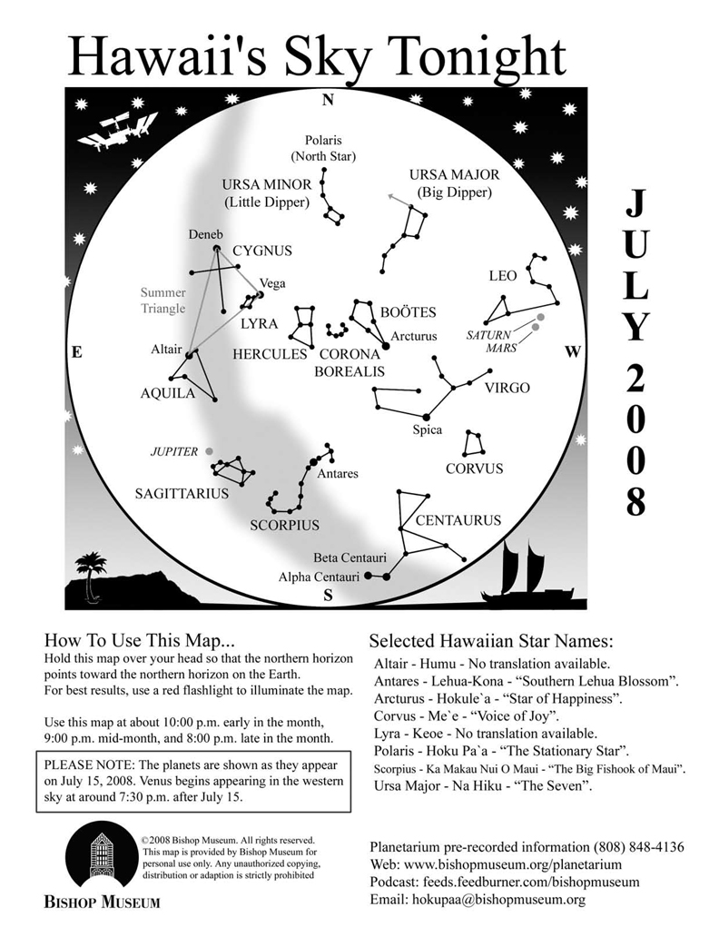
Skywatch Article July 2008 By Carolyn Kaichi, Bishop Museum
PLANETS AND THE SUMMER MILKY WAY
The interesting thing about sky-watching is the fact that although the seasonal constellations are predictable, what you may see at any designated time is not. Planetary movement and other recurring events take place on different cycles than the background of stars so we can’t always count on seeing the same combination of sights in the sky at the same times. That keeps me in business.
So what we will see in the sky this July is not unusual, but a fortunate arrangement of celestial constituents that will be easy and convenient to view. Four naked-eye planets dot the evening skies this month, with two staging a nice pairing together and beautiful Venus making its reappearance back into the night. Although it might be challenging to spot Venus low in the western sky after sunset during the first half of the month, by the end of the July it will be climbing higher out of the light and easier to spot.
A nice highlight will be the conjunction of Mars and Saturn in the constellation Leo on July 9 and 10. The rust-colored planet and pale yellow Saturn have been slowly creeping closer over the past weeks and will be at their closest on those two dates (although the 10th is technically the closest date, both nights are good for viewing). Included in the lineup is the brightest star in Leo, Regulus, which is on that planet highway called the ecliptic. As a bonus, on July 5 a small crescent Moon joins the group as Mars closes in. That evening going from west to east, you can see the Moon next to the star Regulus, followed by Mars and Saturn. Make sure you start early however, because this gathering will set by 10:00 P.M.
Jupiter is also impressive in the east as the sun sets. The giant planet is at opposition now, meaning that it is on the opposite side of our sky than the sun (think “Sun, Earth, Jupiter” in that order). It appears bigger and brighter in the night sky at this time and is visible in the sky the whole night. Now would be a great time to take out a pair of binoculars and look for the famous features that characterize Jupiter, like the Galilean satellites and the distinct bands of color on the planet. The monster hurricane, the Great Red Spot, is visible with telescopes but not necessarily with average binoculars.
While the planets steal the spotlight this month, don’t forget to pay attention to the summer Milky Way! The hazy band of light extending from north to south is part of the galaxy we reside in and offers many binocular and telescopic sights along the way. The area roughly between Scorpius’ stinger and Sagittarius’ “spout” is particularly wide since that direction is the bulbous center of our galaxy, approximately 26,000 light years away. Rather than individual points of light we see the accumulation of the millions of stars obscured by gas and dust. Right now you can see the Milky Way stretching from the southwest in the direction of the Southern Cross (early in the evening) through the Summer Triangle toward Perseus in the northeast in the early morning hours.
EVENING PROGRAM UPDATE
With so many objects to look for in the skies, it’s difficult to cram everything into one article every month. Consider our planetarium as the next best thing to the real sky, one with a personal “guide” to the stars. An evening program is held on the first Fridays of the month, with sky viewing if the weather is clear. However since it falls on the 4th of July this month, the program has been moved to Friday, July 11. It begins promptly at 8:00 P.M. and reservations are strongly recommended. Call 848-4168.
PHOENIX UPDATE
The Phoenix lander is busily performing its tasks since touchdown on Mars a little over a month ago. What the mission has already done for space exploration was demonstrated by the difficult EDL phase, or Entry, Descent and Landing. Many previous missions were lost in this critical phase, including the predecessor of Phoenix, and since one of the science goals of the mission is to prepare for human exploration, NASA had to prove that landing a craft on Mars has improved dramatically. It appears that goal is well on its way. See http://phoenix.lpl.arizona.edu/ for more information.
The Planets
Earth:
The second of two annual opportunities to experience Lahaina Noon comes this month. Between May and July the sun passes directly overhead for areas within the Tropics. During Lahaina Noon objects that are directly perpendicular to the sun, such as flagpoles or fences, have no shadows since the “shadow” would be cast “under” the object. Times vary by location, so check the website for more information: www.bishopmuseum.org/planetarium
Also, aphelion takes place on July 3, the Earth’s farthest point in its orbit around the sun. Coincidentally the Moon is in a new phase at the same time, so the effect of the tides will be enhanced. Higher tides than normal usually occur during this alignment.
Mercury:
Mercury is in the morning sky now, rising around 4:30 A.M. in early July. By the last week it will be too close to the sunrise to spot as it rounds around the backside of the sun to reappear in the evening sky.
Venus:
For the casual viewer, Venus will be very difficult to spot until mid-month, when it is a little farther from the sun in the western sky at sunset. However the “window” to see it will be short for this month since the planet sets before darkness by 8:00 P.M.
Mars:
Mars is cruising through Leo, meeting up with Saturn along the way and by the end of the month will pass through the constellation on the way to Virgo. The planet is slowly receding from us in its orbit and dimming as it goes, but is still easily visible to the unaided eyes.
Jupiter:
Jupiter reaches opposition on the evening of July 9, rising in the east as the sun sets. If the weather is nice, this is an excellent night to see the four evening planets in the sky. You will need to get somewhere you can see all the way to the western horizon, and starting from that point shortly after sunset (around 7:30 P.M.) look for Venus low in the west, followed by Mars and Saturn close together about halfway up in the western sky and Jupiter rising in the east.
Saturn: Although Mars and Saturn are set for a rendezvous Saturn’s position changes very little with respect to the starry background. The ringed planet is much farther away than our neighbor Mars, therefore orbiting the sun at a slower rate of speed. Where Mars orbits the sun in almost 687days, Saturn takes 29.5 years!
Questions? Contact Carolyn Kaichi @ hokupaa@bishopmuseum.org or 847-8203.
For more information on visiting Hawaii in general or touring the Big Island in particular, go to www.tourguidehawaii.com or here.
A littoral explosion at dusk. Explosions such as this have been common throughout the last several weeks at the Waikupanaha entry. June 29, 2008.
One of the most surprising aspects of the current summit eruption at Kīlauea Volcano, which started in March of this year, is that there has been almost no change in surface deformation trends. Past summit eruptions have been accompanied by rapid inflation prior to the start of an eruption, followed by equally rapid deflation. During the present period, however, the summit of Kīlauea has shown no change from the trend of gradual deflation since July 21, 2007, when the eruption site migrated about 2 km (1.5 miles) downrift from Pu`u `Ō`ō. No change, that is, until just a few weeks ago.
On June 24, tiltmeters at Kīlauea's summit and at Pu`u `Ō`ō began showing inflation-the first time sustained inflation has occurred at both sites since July 21, 2007.
In addition to the change in ground deformation, other types of monitoring data indicated a shift in the style of eruptive activity. Throughout early and mid-June, the intensity of the glow from the summit vent had decreased, relative to the strong glow seen in April and May. In late June, however, the summit vent began glowing brighter.
The intensity of the glow, in fact, correlates with bursts of seismic tremor that occur every few minutes, with more glow during the tremor bursts and less between bursts. These tremor bursts also increased in magnitude and frequency in late June. The correlation between tremor and glow led HVO scientists to infer that gas bubbles were bursting through a crusted lava surface beneath the Halema`uma`u vent. Increases in the strength of both the glow and tremor bursts may have indicated rising of the lava surface.
Another late June change in activity was the occurrence of surface lava flows from the east rift zone for the first time in several weeks. Lava broke out of the tube system, both on the east rift zone and above the Royal Gardens subdivision. At the same time, enough lava was being transported through the tube system to result in spectacular littoral explosions at the ocean entry during early July. All of these signs point to a lava tube system that was full to the point of overflowing.
Taken together, this evidence suggests that Kīlauea was engorged with magma, starting in late June. Increased magma in the caldera and east rift areas resulted in inflation of the summit and Pu`u `Ō`ō and, possibly, rising of the lava column in the Hamema`uma`u vent. Magma was also being delivered to the eruption site at a greater rate than normal, resulting in the numerous surface lava flows.
What might be the result of such activity? It is conceivable that more magma within Kīlauea's plumbing system could result in a change in the east rift zone eruption site, much like that which occurred in mid-2007. Lava might even erupt from the Hamema`uma`u vent, forming a lava lake at the summit.
Of course, Pele seems to enjoy keeping us on our toes. On July 1, deformation at Pu`u `Ō`ō stabilized, and the summit began to deflate, suggesting that even more magma was being fed from the summit to the east rift zone eruption site. Lava flow activity on the east rift zone and above Royal Gardens continued to increase. On July 7, a spectacular fountain formed near the TEB (Thanksgiving Eve Breakout) vent, possibly due to partial blocking of the lava tube system. At the summit, however, the intensity of glow from the Halema`uma`u vent has waned, suggesting that, at least for the moment, volcanic activity will focus on the east rift zone.
The weeks since June 24 have been a significant departure from "normal" trends of deformation during the current summit eruption, and also saw the most surface lava flow activity in several months. What caused Kīlauea to suddenly fill with magma and, just as suddenly, begin to drain?
One explanation is that the lava supply to Kīlauea fluctuates on timescales of days to weeks, causing rapid changes in surface deformation and eruptive activity. Although the causes of these fluctuations are not clear, the variations obviously are an important control on the activity we observe at the surface.
HVO will remain vigilant for future changes in the amount of magma coursing through Kīlauea's veins. Such activity should be easy to detect, given the excellent seismic, deformation, gas, and visual monitoring of the volcano, both at the summit and along the east rift zone. We invite you to follow along by checking HVO's Webcams, data plots, and daily activity updates available at http://hvo.wr.usgs.gov.
Activity update
Kīlauea Volcano continues to be active. A vent in Halema`uma`u Crater is erupting elevated amounts of sulfur dioxide gas and very small amounts of ash. Resulting high concentrations of sulfur dioxide in downwind air have closed the south part of Kīlauea caldera and produced occasional air quality alerts in more distant areas, such as Pahala and communities adjacent to Hawai`i Volcanoes National Park, during kona wind periods.
Pu`u `Ō`ō continues to produce sulfur dioxide at even higher rates than the vent in Halema`uma`u Crater. Trade winds tend to pool these emissions along the West Hawai`i coast. Kona winds blow these emissions into communities to the north, such as Mountain View, Volcano and Hilo. As of this writing (July 10), the gas vent below the east rim of Pu`u `Ō`ō was spattering weakly, with some spatter reaching the crater rim. At least two other vents within the Pu`u `Ō`ō crater were also spattering. The one near the western end of the crater was spattering vigorously and sporadically, feeding a small lava pond on the crater floor.
Lava continues to erupt from fissure D of the July 21, 2007, eruption and is supplying several breakouts along the 2007 Thanksgiving Eve Breakout (TEB) tube system above the pali and near the top of Royal Gardens. Activity was quite vigorous early in the week, feeding multiple breakouts, including a 10-15-m-high lava fountain. By July 10, activity had diminished, with only sparse surface flows observed.
Lava also continues to flow through what remains of Royal Gardens and across the coastal plain to the ocean in a well-established lava tube active now for several months. When the surface activity intensified upslope early in the week, the Waikupanaha ocean entry diminished significantly and appeared nearly inactive. Full vigor had returned by July 10, with small explosions and a large plume.
Be aware that lava deltas could collapse at any time, potentially generating large explosions. This may be especially true during times of rapidly changing lava supply conditions, as have been seen lately. Do not venture onto the lava deltas. Even the intervening beaches are susceptible to large waves generated during delta collapse; avoid these beaches. In addition, steam plumes rising from ocean entries are highly acidic and laced with glass particles. Check Civil Defense Web site (http://www.lavainfo.us) or call 961-8093 for viewing hours.
Mauna Loa is not erupting. Two earthquakes were located beneath the summit this past week. Continuing extension between locations spanning the summit indicates slow inflation of the volcano.
Four earthquakes beneath Hawai`i Island were reported felt within the past week; all occurred on Tuesday, July 8, 2008. A magnitude-2.7 earthquake occurred at 00:06 a.m., H.s.t., and was located 2 km (1 mile) southwest of Kīlauea summit at a depth of 1 km (1 mile). A magnitude-3.2 earthquake occurred at 00:38 a.m. and was located 3 km (2 miles) southwest of Kīlauea summit at a depth of 400 m (0.2 miles). A magnitude-2.8 earthquake occurred at 7:36 a.m. and was located 5 km (3 miles) northwest of Pa`auilo at a depth of 9 km (5 miles). A magnitude-1.8 earthquake occurred at 10:09 p.m. and was located 3 km (2 miles) southeast of Captain Cook at a depth of 8 km (5 miles).
Visit our Web site (http://hvo.wr.usgs.gov) for daily Kīlauea eruption updates, a summary of volcanic events over the past year, and nearly real-time Hawai`i earthquake information. Kīlauea daily update summaries are also available by phone at (808) 967-8862. Questions can be emailed to askHVO@usgs.gov.
For more information on touring Hawaii in general, or visiting the Big Island in particular, go to www.tourguidehawaii.com and here.
Tour Guide is the most innovative travel product ever offered to Hawaii visitors. More than a simple navigational GPS, Tour Guide contains over 500 points of interest, thousands of photographs and hours of interesting, fun and informative audio.
In addition to turn-by-turn directions to everywhere on the Big Island, Tour Guide provides geographically-queued video presentations about every site of interest along the way, and tells you what to expect when you arrive. Tour Guide will even help you find the nearest restroom anywhere. Best of all, Tour Guide is very easy to use; just push a button and go! Want to plan your trips in the comfort of your hotel room? In Browse Mode, Tour Guide makes it as easy as watching TV. ENJOY!
For more information, visit: www.tourguidehawaii.com.