HawaiiVolcanoesNational Park: Chain of Craters Road
Hawaii Volcanoes National Park is one of the great natural wonders, as well the most studied volcanoes, on earth. Few places can the visitor get as many diverse climates, flora, fauna and geologic dreamscapes as inside the park’s boundaries.
Continuing down the Chain of Craters Road, there are numerous turnouts with panoramas that stretch the imagination. Tour Guide adds to the excitement with all the information about what is being seen. Take a quick stop at Alanui Kahiko. The words in Hawaiian mean old road. Here you will see portions of the old Chain of Craters Road, some 12 miles worth above and below this lookout, buried under 300 feet of lava by the 1972 eruptions. This spectacle alone is testament to the awesome destructive powers of Madam Pele, the volcano’s Fire Goddess.
A few miles further down the mountain is the Pu’u Loa Petroglyph field. It can be found along the side of the Ka’u-Puna Trail, a trail used by ancient Hawaiians. This is believed to be the largest petroglyph field in Polynesia, containing more that 15,000 carvings. The path to the petroglyphs is marked from the parking lot by cairns. Tour Guide will show you where to park and explain some of the carving’s meanings at this phenomenal spot.
At about the 19 mile marker is the current End of the Road, the location where the lava cut off the road in 1983. A year ago, you could park here and trek across the barren fields to where the lava was entering the ocean. Now, however, the lava has changed course and is sometimes entering from the Puna side of the park. There is still a ranger’s station here and many placards telling about the flows and safety precautions for hiking in the desolate area. Restrooms are available.
Walking down to the ocean at the End of the Road are some beautiful formations, most notably, the Holei Sea Arch. Tour Guide will tell you how arches and stacks are formed when the waves pound against the sea cliffs and chisel into the various lava densities. The cliff around this arch is some ninety feet, so use caution as you photograph this amazing sight.
Looking back up the mountain gives one the perspective of the destruction, yet the immaculate life giving beauty, of the fire goddess Pele who is in constant battle her sister, the ocean. Each takes life, and gives it. We as humans can stand in awe at the majesty and wonder of these two great forces, respecting each on its own terms.
As you travel back up the Chain of Craters Road, don’t forget to stop at some of the vista points and take photos and videos of the landscape, the memories and the people that are like nowhere else on earth, the Island of Hawaii.
The most unique product ever offered to visitor's of the Hawaiian Islands, Tour Guide offers GPS-guided, location aware tours in the palm of your hand. For more information see www.tourguidehawaii.com or www.lovingthebigisland.wordpress.com.
Today: Scattered showers after noon. The rain could be heavy at times. Widespread haze. Cloudy, with a high near 80. West wind between 3 and 5 mph. Chance of precipitation is 30%. New rainfall amounts between a tenth and quarter of an inch possible.
Tonight: Scattered showers. The rain could be heavy at times. Widespread haze. Cloudy, with a low around 68. Calm wind. Chance of precipitation is 40%. New rainfall amounts between a half and three quarters of an inch possible.
Saturday: A chance of showers and thunderstorms, then showers likely and possibly a thunderstorm after noon. Some of the storms could produce heavy rainfall. Widespread haze. Mostly cloudy, with a high near 79. East wind at 5 mph becoming south. Chance of precipitation is 60%. New rainfall amounts between three quarters and one inch possible.
Saturday Night: Scattered showers and thunderstorms. Some of the storms could produce heavy rainfall. Widespread haze. Mostly cloudy, with a low around 66. East wind around 7 mph. Chance of precipitation is 50%. New rainfall amounts between a half and three quarters of an inch possible.
Sunday: Scattered showers. The rain could be heavy at times. Widespread haze. Mostly cloudy, with a high near 80. South wind 6 to 8 mph becoming west. Chance of precipitation is 40%. New rainfall amounts between a half and three quarters of an inch possible.
Sunday Night: Scattered showers. The rain could be heavy at times. Widespread haze. Mostly cloudy, with a low around 66. East wind around 9 mph. Chance of precipitation is 30%. New rainfall amounts between a quarter and half of an inch possible.
Monday: Scattered showers, mainly after noon. The rain could be heavy at times. Widespread haze. Partly cloudy, with a high near 81. West wind around 9 mph. Chance of precipitation is 30%.
Monday Night: Isolated showers. Widespread haze. Partly cloudy, with a low around 66. East wind around 9 mph. Chance of precipitation is 20%.
Tuesday: Scattered showers. Widespread haze. Partly cloudy, with a high near 82. West wind around 9 mph. Chance of precipitation is 30%.
Tuesday Night: Isolated showers. Widespread haze. Partly cloudy, with a low around 66. East wind around 8 mph. Chance of precipitation is 20%.
Wednesday: Scattered showers. Widespread haze. Partly cloudy, with a high near 81. West wind around 8 mph. Chance of precipitation is 30%.
Wednesday Night: Widespread haze. Mostly clear, with a low around 66. East wind around 7 mph.
Thanksgiving Day: Scattered showers. Widespread haze. Mostly cloudy, with a high near 82. South wind around 7 mph. Chance of precipitation is 30%.
Mauna Ulu, or growing mountain is a tall, sloping, shield-shaped hill formed by numerous eruptions along the rift between 1969 and 1974; Mauna Ulu is best seen by walking a few yards past the road beyond the parking lot to where the end of road is covered in fresh lava flows. At Mauna Ulu, visitors can get an intimate look at both pahoehoe and aa lava flow types. Pahoehoe, the less viscous and generally hotter liquid flow, moves fluidly like a river or glacier, the surface folding and molding, like poured taffy, into a ropy structure. Pahoehoe forms generally flat, fairly smooth, hard surfaces. Aa, on the other hand, is much cooler and has exolved much of its dissolved gas, so it is much more viscous, causing the upper surface to fracture into clinker-like boulders and fragments. Flowing aa sounds and looks like a moving pile of hot glass shards; when it cools, it leaves behind rubbly piles of sharp fragments. Fields of pahoehoe and aa make a landscape that look as if Madame Pele has bulldozed her land to flat surfaces, but left these acres of boulder piles here and there.
Pu'u Huluhulu (shaggy hill) is a 150 foot tall cinder cone formed in pre-contact times between Mauna Ulu and Pauahi Crater. There is a fascinating 3 mile round trip hike from the Mauna Ulu parking lot to the top of Pu'u Huluhulu that is marked by cairns (or ahu). From the vantage point of Pu'u Huluhulu's summit, one can see Pu'u O'o (hill of the bird) about 5 miles away. From Pu'u Huluhulu are fine views of Mauna Loa, Kilauea, Mauna Kea, the coastline and Pu'u O'o. Pu'u O'o is a spatter cone built by the fire-fountains erupting along Kilauea's rift zone between 1983 and 1986. Since 1986, the center of eruption has moved about 2 miles further down the rift to a vent called Kupaianaha, or mysterious in Hawaiian. The round trip hike from Mauna Ulu Parking lot to Pu'u Huluhulu and return takes about an hour and a half to two hours.
The hike to the summit of Mauna Ulu is a long, dry, serious hike with some dangers and should only be undertaken by those in good physical condition and experienced at hiking cross-country across broken and hazardous ground.
Written and produced by Donnie MacGowan; videography by Frank Burgess and Donald MacGowan; narrated by Frank Burgess; original musical score written and performed by Donnie MacGowan.
Now run by a private foundation, Kilauea Military Camp was built as a military R and R camp shortly after World War 1 and operated through the Vietnam conflict. Now it offers small but clean cabins for rent to active and retired military members.
Produced by Donnie MacGowan; videography by Donnie MacGowan and Frank Burgess; Narrated by Frank Burgess; original music written and performed by Donnie MacGowan.
Aloha! I'm Donnie MacGowan and I live on the Big Island of Hawaii. Today, I'd like to take you to the top of Mauna Kea. At 13, 796 feet above sea level, Mauna Kea's summit is the highest point in the State of Hawaii; since its base lies at 19000 feet below sea level, its has a base-to-summit height of 33,000 feet, making it the tallest mountain on earth. It's also one of my most favorite places on earth.
Mauna Kea began forming on the sea floor about one million years ago. Its name means "White Mountain" in the Hawaiian language and it is snowcapped much of the winter, and the summit is covered with permafrost 35 feet deep. During the ice ages, Mauna Kea's summit was glaciated 3 times, starting about 200000 years ago and ending only 11000 years ago. One can see the U-shaped valleys and cirques, striated bedrock, glacial tills covering the summit area and remnants of ice-damned lava flows from those times. There are even the remains of extinct rock glaciers near the summit.
The Visitor's Center and summit are reached via a road which turns off Saddle Road at about 6600 feet elevation near the 28 mile marker and tortuously stumbles its way up the south side of Mauna Kea to the Visitor Information Station at about 9300 feet. The road, though steep, is paved to the Visitor's Center. Above that, the road is graded dirt for about 5 miles, returning to asphalt paving for the final sprint to the rim of the summit crater. Road conditions for the summit road are available at 808.935.6263.
The visitor's center is open from 9 a.m. until 10 p.m. 365 days a year. Informational multimedia presentations, souvenirs, and some food items are available here, as well as clean restrooms and drinking water. Every evening after dark the center allows visitors to stargaze through several telescopes and informational talks by visiting scientists are occasionally scheduled. Saturday and Sunday Center staff lead escorted summit field trips, but visitors must provide their own vehicle. Call 808.961.2180 for information. It is suggested that summit-bound visitors stop at the Visitor's Center for at least half an hour before heading to the summit so they can acclimate.
Above the Visitor Information Station there are no public accommodations, no water or food and no gasoline service; the observatory buildings are closed to the public and usually locked. There are neither public telephones nor restrooms, only port-a-potties. An emergency phone is located in the entrance to the U of H 2.2 meter Telescope building.
Driving the summit road to the very top of Mauna Kea is neither as dangerous as the car rental companies want you to believe, nor as casual as many Big Island residents will tell you. True, the summit road is unpaved most of the way, it is steep and winding with limited view planes; the road is extremely hazardous when wet or icy, which is often, and it’s subject to frequent dense clouds, snow, rain and fog obscuring all vision. Also, balmy summer conditions may turn into lethal winter rages in minutes with little or no warning.
However, the road is generously wide, routinely graded and poses no real threat to the cautious driver. The safe driver can expect to reach the summit in about ½ an hour after leaving the Visitor Information Station. Remember, it’s not the roughness of the road that will impede your car; it’s the elevation that will starve it for oxygen. To be safe, take as much time winding your way back down the mountain as you took coming up, using the lowest gear to save wear on brakes. Check your car rental agreement--many forbid you to drive this road. If you go anyway, your insurance is void, and you do so at considerable financial risk. Remember, people DO crater their cars on occasion.
If the weather turns frightful, simply head down immediately. Relax, be calm and drive carefully; you can be confident that, even if you have to slow to 10 miles per hour in places, you'll be down to the safety of the Visitor's Center in a mere 40 minutes or so.
The summit of Mauna Kea, hosting the largest assemblage of astronomical instruments and telescopes in the world, is truly an amazing place; a seductive juxtaposition of icy heights raised up from steaming tropical jungle; the age-old altars of sacred Hawai’ian gods alongside edifices of the most modern of sciences; of frigid landscapes carved during ancient ice-ages alongside fiery volcanic landforms; all wrapped around a fabulous trip with a wee rumor of danger, just for spice! Beautiful, awe-inspiring, 360 degree views of the entire Big Island also include the islands of Maui, Kaho’olawe and Lana’i on clear days. The glow from Kilauea Volcano can be seen on clear nights. Although daytime temperatures during the summer can peak in the 60s, it is generally cold-to-frigid, frequently wet and very windy on the summit. Plan and dress accordingly.
The summit area is also culturally and religiously important to the native Hawai’ians, hosting many religious Heiau, an obsidian adze quarry and numerous other archaeological sites. Remember this landscape, and the archeological sites upon them, are sacred; take nothing but photographs, don't even leave footprints.
Parking is limited, but the hike from the top of the road to the actual summit is a must for any who have ventured this far and are in good shape. A stone altar and a USGS survey point mark the actual summit of the mountain, about a 15 minute walk up a cinder trail from the top of the road. A trail leading around the summit crater takes about 30 minutes to trek and traverses some very wild country with amazing views. Be sure to bring plenty of drinking water and hydrate frequently to help stave off altitude sickness. Do not leave the safety of the parking lot if you are feeling ill or the weather is at all chancy—in fact, in deteriorating or poor weather, or at the onset of queasiness, one should leave the summit immediately and descend.
Alternately, for those in excellent physical condition, one can hike to the summit from the Visitor's center. Featuring unparalleled views, wild landscapes, archeological sites and more, the hike is about 6 miles in length, gains about 4500 feet in elevation and takes 6 to 10 hours to get up, depending on the hiker. There is no water available anywhere above the Visitor's Center, so take enough to get up, and back down. Frankly, many people opt to hitch-hike down the mountain after hiking up. In fact, for folks short on time, or for whom scenery and not summit-conquering are the main goals, catching a ride to the summit and hiking down is a great alterative, and takes only about 3 1/2 hours.
Another absolutely stunning hike in the summit area, one that is accessible to nearly anybody in reasonable condition, is to Lake Wai'au. Park at either the lot at about 12000 feet, near the 5 mile marker, or the lot at about 13000 feet, near the 7 mile marker. Needless to say, one hike is uphill in and the other is uphill out; but both are less than a mile long and have similar elevation changes. I prefer the upper trail because the view of the summit astronomical complex on the hike out is phenomenal. An absolute jewel of an alpine tarn in its own right, at 13,020 feet Lake Wai'au is one of the highest permanent lakes in the world...permafrost seals the lake bed in the loose tephra and glacial drift on which it sits. It's about 300' by 150' by 8 feet deep and, yes, I personally can vouch for its having been snorkeled. Not much to see in there, though.
There are a few health concerns about visiting the summit of Mauna Kea as well. In brief: children under 16, pregnant women, and people with respiratory, heart, or severe overweight conditions are advised not to go higher than the Visitors Information Station. Scuba divers must wait at least 24 hours after their last dive before traveling to the summit.
Acute mountain sickness, resulting from exposure to high altitude, includes nausea, headache, drowsiness, shortness of breath, and poor judgment. Aspirin and lots of water are palliatives for altitude sickness, but the cure is immediate and rapid descent. Sufferers will notice almost complete cessation of symptoms upon regaining The Saddle. Altitude sickness can be dangerous, even life threatening, and rapid onset of comatose condition, or even death, may be unexpectedly swift.
Finally, there is severe risk of serious sunburn and eye damage, particularly when there is snow on the ground. Be sure to wear sunglasses rated to at least 90% IR and 100% UV (both UVA and UVB); wear sunscreen rated to at least SPF 30. Long sleeves and pants help reduce the susceptibility to sunburn.
No trip would be complete without wild life footage; this was the only other living thing on the summit the day I shot this...and just to prove where we are, yup, there's the summit!
Most visits to Mauna Kea's summit are extremely pleasant experiences, encompassing easy adventures which may feature mild altitude euphoria, fabulous views and a great sense of relief at reaching the paved road and public restrooms at the Visitor’s Information Station after leaving the summit.
Well...thanks for spending a little time with me in one of my favorite spots...I've got to run now...this is Donnie MacGowan sending you a hearty "Aloha!"
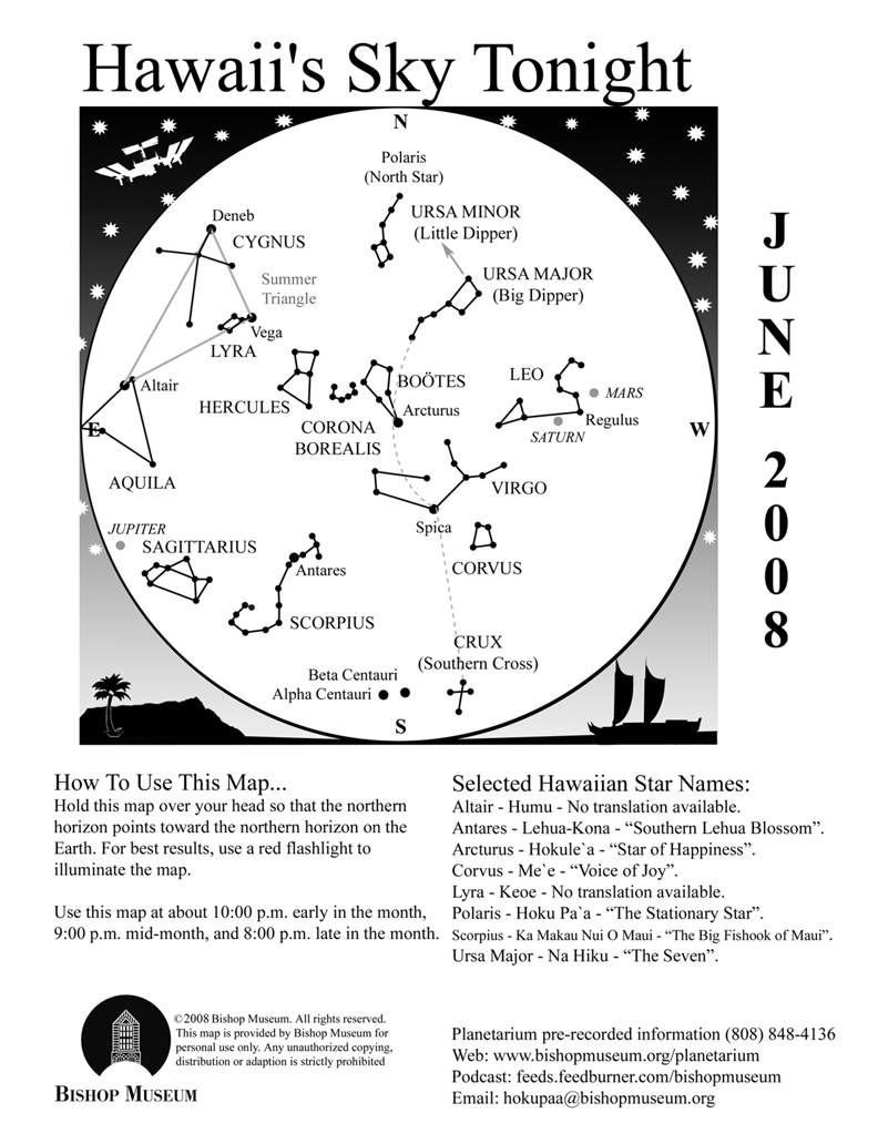
The patterns we see in the sky exist only in our imagination. The points of light we group to create the shapes we call constellations are arbitrary and usually don’t have any connection with each other at all except that they happened to line up in someone’s mind at one time. The 88 “official” constellations are recognized by a group of professionals called the International Astronomical Union to help keep order and structure to the science of astronomy. Otherwise, imagine what chaos might reign—how would anyone know how to distinguish one part of the sky from another if names were random? For instance, the constellation Crater the Cup in the southern sky next to Corvus looks remarkably like my Weber grill, but I can’t very well start referring to it as such. As it is, we sometimes “shorten” the constellations anyway. Sagittarius is often referred to as the Teapot, and part of the Big and Little Bears are called the Big and Little Dippers, respectively.
Informal groupings or segments of constellations are called asterisms. They are usually parts of constellations that are more easily recognized, like the Dippers and the Teapot, and at times the references are updated. Some constellations are simply easier to recognize by these nicknames. I have heard the constellation Boötes the Herdsman referred to as a “bowtie” or “ice cream cone”, which most people relate to better.
Sometimes asterisms include groups of stars or constellations, like the Summer Triangle. Known anecdotally as a basic element of celestial navigation, the Summer Triangle is comprised of the three brightest stars in three separate constellations forming a large, distinctly triangular shape in the sky. First to rise in the east is the star Vega in the constellation Lyra the Lyre. Lyra is a small constellation that takes a bit of effort to imagine the harp-shaped instrument from the parallelogram of stars, but it is an area rich in telescopic sights. One is the famous Ring Nebula, M57—a little smoke-ring object that is the remains of a dying star seen at the center of the ring.
Vega is a white star and the fifth brightest star in the sky. Twelve thousand years ago Vega used to be our North Star, but because the Earth slowly “wobbles” (think of a spinning top, except our wobble is 26,000 years long!) the North Pole points toward different stars periodically. Right now, almost halfway through the wobble’s circle, Polaris is our North Star but in another 14,000 years Vega will take that title again.
Almost two hours after Vega rises the second point of the Triangle appears in the east in Cygnus the Swan. Although this constellation can be easily visualized as a bird, it does have an asterism associated with it. Part of the body and wingspan of the Swan is known as the Northern Cross. The star Deneb is the tail feather of the bird and is the brightest star in that constellation. Opposite from Deneb is an interesting star called Alberio. With a low powered telescope or even binoculars what looks like a single star will split into a beautiful sapphire blue and golden pair of stars.
A half hour later, Altair in Aquila the Eagle makes its appearance over the eastern horizon. Altair and Vega represent two figures in Japanese folklore that are celebrated with a national holiday in the country. Altair is the handsome herdsman Hikoboshi (also known as Kengyu) that fell in love with Orihime (Vega), the beautiful fabric-weaver. Their preoccupation with each other began to interfere with their duties, and as a result the gods separated them across a vast river in the sky. You can see that “heavenly river” in the dark sky as the white band of light called the Milky Way.
Fortunately, the story doesn’t end here—the gods heard the unhappy cries of the two lovers and took pity on them. On the seventh day of the seventh month, the two are united for one day as a flock of magpies build a living bridge to bring the two together. Today this occasion is celebrated by a festive holiday called Tanabata in Japan on July 7, although in early times this date was determined by the lunar calendar.
Following the Summer Triangle (and the parallelogram of Lyra) is the big Square of Pegasus. But because it is not included on this month’s map, I will save that “astro-geometry” lesson for another month!
The Planets
Earth:
Summer kicks off, at least astronomically, with the solstice on June 20. At 2:00 P.M. HST the sun crosses from the southern hemisphere into the northern hemisphere, marked by the celestial equator. (The celestial equator is an imaginary line that extends the Earth’s equator into space)
Mercury:
Mercury is passing in front of the sun for most of the month and will reappear in the morning sky during the last week of June. It hangs over the red “bull’s eye” of Taurus in the light of the rising sun.
Venus:
Venus is behind the sun right now, what is referred to as superior conjunction. It will be another month before it will appear back in the evening sky and blaze in the west after the sun sets.
Mars:
Mars quickly moved from Gemini through Cancer last month and will settle in the constellation Leo during June. Saturn has also been a resident of Leo recently and the two planets are heading for a conjunction in July. You can watch the Red Planet edge closer to yellowish Saturn over the month, with Regulus (the brightest star in Leo) in the middle.
The NASA mission to Mars, called Phoenix (see May’s article) will make its descent to Mars on May 25. Unfortunately I cannot update the status of this mission because this article is filed before this date, but I will definitely talk about Phoenix next month.
Jupiter:
The King of Planets rules the night, shining brighter than any other object besides the Moon this month. Jupiter rises by 10:00 P.M. in early June and about two hours earlier by the end of the month. On June 18, the full Moon enters Sagittarius, the same constellation as Jupiter, and the next evening the waning Moon moves just south of the giant planet.
Saturn: Look for Saturn high in the west at nightfall during the first half of June, then only about halfway up in that direction by the end of the month. The rings of the gas planet is continuing to tip edgewise to our line of sight and well worth watching over the upcoming months. You will need a telescope to really appreciate this sight, however.
This is a good example of the embarrassment of riches in West Hawai'i in terms of our archaeological heritage, and the disrespectful and wasteful way which we deal with these important resources.
Here at Lonoikamakakahiki Residence is a king's palace, 500 years old, and built by one of Hawai'i's greatest kings, King Umi. This site was later inhabited by at least two other important kings (Lonoikamakakahiki and Kalanio'pu'u) as well as Kamehameha the Great. In any other state this would be an archaeological treasure, a park or preserve, but certainly showcased and cared for. In this case, in Hawai'i, a very few remnant walls were grudgingly reprieved from the bulldozer's blade when the Kona Surf and Racquet Club was built by the Bishop Estate (Kamehameha Schools); the rest of this historical treasure was bulldozed into oblivion for all time. It is not even generally available for causal viewing, locked away behind the Kona Surf and Racquet Club's iron gates where only paying Club guests and pedestrian visitors can see it. Of course, there is no available (legal) parking nearby, but if you are willing to walk the half mile or so up Ali'i Drive, parking is available at Kahalu'u Beach Park.
Melancholy, lonely, desolate; this beach cut into the fresh scar of an a'a flow marks the place where the Hawai'ian gods died at the battle of Kuamo'o. In 1819, the year before the Christian missionaries arrived in Hawai'i, forces loyal to Kamehameha II and Queen Ka'ahumanu fought to overturn the kapu system and the pagan Hawai'ian religion in favor of Christianity. Kahuna Kekuaokalani led the last supporters of the old ways and the old gods and fought a desperate battle here to preserve their ancient way of life, and lost. Their graves, numbering in the several hundreds despite the official-looking marker at the site, are under the numerous, large stone altars erected by the victors over the very spots the warriors fell.
A walk along the dirt road that bisects the battlefield is ineffably sad and a little creepy. However, the road soon climbs into dryland forest along the lava ocean cliffs and provides some memorable hiking and sunset views.
Kuamo'o Battlefield is located at the very end of Ali'i Drive, somewhat appropriately. No facilities.
The remains of Hapaial'i Heiau (Temple for Elevating Chiefs), a heiau associated with ceremonies involving changes in rank of Ali'i, lie on the grounds of the Keauhou Ohana Beach Resort, across the narrow tidal inlet from Ke'eku Heiau. Not much is known about this Heiau; some traditions hold that it predates Ke'eku Heiau; others maintain it was built around 1812 by Kamehameha the Great.
To reach Hapaiali'i Heiau, park either in the Kahalu'u Beach Park or at Keauhou Ohana Beach Resort. From Kahalu'u, walk onto the Keauhou Ohana Beach Resort property through the gateway in the fence between them and follow the asphalt path to the pool deck, through the lobby of the resort and join the paved path that runs along the end of the Resort driveway. From the Resort parking lot, walk up the drive to the paved path that runs along the end of the driveway. Following along this path, one passes Punawai Spring first, then, where the path runs around the end of the tennis courts the homesite of the Mo'o Twins. Continuing on the path until it ends at a broken concrete bridge among "No Trespassing" signs, the Hapaial'i Heiau is immediately between you and the ocean; all that remains of this once impressive temple are an unpresupposing stack of stones and some tumbling walls. Remember that these are holy religious sites to modern native Hawai'ians; to not trespass, walk or climb on the temple proper; take nothing but photographs, leave nothing but footprints.
For more information on exploring the ancient temples of Hawaii, visit www.tourguidehawaii.com, www.lovingthebigisland.wordsmith.com and www.tourguidehawaii.blogspot.com
Maka O Hule Point: Navigational Heiau at Mahukona Point
Near mile marker 15 on the Akoni Pule Highway is a unique navigational heiau of standing stones arranged to point to Tahiti and the other Polynesian islands.
Sometimes referred to as "the Stonehenge of Hawaii", this one of a kind temple is reached via a short, easy stroll long the dirt road leading north, away from Mahukona Beach Park on the Kohala Coastline. Lovely vistas along deep, cerulean and clear coves lead to a short scramble up an obvious dirt trail to the heiau.
Among the stones, one can sense the reverence and wonder of the Hawaiians as they initiated their novice navigators in this sacred spot of stones pointing along unbroken vistas to Tahiti, the Marquesas and the other Southern Islands. This is a spot for contemplation and awe. Wonderful and startling sunset photos with the stones in the foreground can be taken here, but be respectful and do not walk within the temple precincts.
This heiau is most easily accessed from Mahukona Beach Park, although one can also hike down from the makai, or ocean side of the Akoni Pule Highway near mile marker 15.
Kilauea eruption blasts rocks across landscape Reprinted from the Honolulu Advertiser webpage; for more pictures, go here; for recent volcano video, go here, here and here. Information about seeing the lava is here.
March brings in the spring season with the vernal equinox, the moment when the sun crosses the celestial equator on the way up to the northern hemisphere. This is also the beginning of “cross season”, or the time you can view the Southern Cross in the evening sky. The Southern Cross, also known as Crux, is the smallest of the 88 officially recognized constellations.
Here in Hawaii, this constellation is known as Hanaiakamalama, or “cared for by the Moon” and is part of the modern Polynesian navigational “star line” called Ka Iwikuamo’o, “The Backbone”. In Polynesian navigation this is one of the four reference lines of stars that runs from the north sky to the south. The Backbone starts with the North Star, Hokupa’a, through Ursa Major, Hokule’a (the star Arcturus), Hikianalia (Spica) in Virgo, Me’e (the constellation Corvus), finally to the Southern Cross.
You can start looking for the Southern Cross just before midnight looking out over the ocean on the Leeward side. There are four bright stars that make up the kite shape with a smaller fifth star between the second and third bright star (if you count the top star as number 1, then go clockwise). You can see the Southern Cross on the flags of many countries of the southern hemisphere, like Australia, Samoa and Papua New Guinea since this constellation is more prominent in the southern skies.
The Southern Cross was visible at least 5,000 years ago at higher latitudes in North America and Europe. According to one historian the Southern Cross was seen in Jerusalem at the time Christ was crucified. But because of precession, the “wobbling” of the Earth’s axis, the Cross is no longer visible at higher latitudes in the northern hemisphere.
Even here in Hawaii at 20 degrees north of the equator, the Southern Cross does not get very high above the horizon. Standing completely upright, the top star (Gacrux) is only a mere 12 degrees. In fact, the distance between the top and bottom stars of the upright Cross is the same distance as the bottom star (Acrux) to the horizon—another navigational feature. In the southern hemisphere, draw an imaginary line between the top and bottom stars and they will point the way to the South Celestial Pole. In the northern hemisphere, the North Star conveniently marks the North Celestial Pole but there is no equivalent star in the south.
Because the Southern Cross is so low in the sky and close to the South Celestial Pole, its path in the sky is short. From the time it rises to the time it begins to set it is only in the sky for around six hours, whereas objects that rise closer to due east and set due west takes approximately 12 hours to traverse the sky. In other words, don’t expect to see the Southern Cross in the sky all evening long!
Earlier in the evening you will still see the signature stars and constellations of the winter—Orion, Taurus, Gemini and Auriga are some of the more famous. Orion’s dog, Canis Major (translated as “Big Dog”, not too original but descriptive) has the distinction of having the brightest star as seen from the Earth. Sirius’ status as the brightest star has more to do with its closer proximity rather than its properties—there are many larger and luminous stars in our skies but they are just farther away. Low in the south under Sirius is Canopus in Carina, the second-brightest star in our sky.
Looking to the east of Canopus, you can see another cross-like shape—surprise, you found the “False Cross”! The False Cross is actually made up of stars from two separate constellations that are low in the southern skies. The stars of Vela the sails, and Carina the keel, comprise the False Cross. Those two constellations along with Pyxis the compass and Puppis the stern make up pieces of the ship Argo that carried Jason and the Argonauts on great adventures in Greek mythology.
The “real” Cross will be visible in the sky until around July, when it will then begin to set by the time darkness falls. To find the real Southern Cross, remember that Orion and pals are low in the west by the time the Cross starts to rise and look for the two “pointer stars” to the east of the constellation that point to the top star of the Cross. These stars are Alpha and Beta Centauri in the constellation Centaurus.
The Planets
Earth:
The Vernal Equinox falls on March 19 here in Hawaii, 7:49 P.M. HST. This is the earliest spring date since 1896. Also, Daylight Savings Time begins Sunday, March 9. ADD an hour to most times on the mainland.
Mercury:
Mercury and Venus spend the month huddled in the eastern morning sky just before the sunrise. On March 5 a very thin crescent Moon will join the pair. Neptune and eventually Uranus are also in the vicinity (Uranus comes close to Venus in the last half of the month), and Jupiter is also high in the sky at the time. You will need a telescope to view Neptune and Uranus.
Venus:
Venus rises around 5:30 A.M. at the beginning of March, close to neighbor Mercury. By the end of the month it is getting very close to the sunrise and more difficult to see, rising only around 45 minutes before the sun. Venus is making its way back to the evening sky and will pass in back of the sun (superior conjunction) in June.
Mars:
As we get closer to the summer months the sky darkens later, so although Mars is high in the sky by 7:00 P.M. it will be hard to spot right away. We are already leaving Mars behind after passing by in December last year, and as the Red Planet recedes it looks smaller and dimmer in our night sky. Throughout March Mars sits above the horns of Taurus next to the legs of the brother Castor in Gemini.
Jupiter:
Jupiter rises by 3:45 A.M. in early March right off the handle of the Sagittarius “teapot” asterism. Until Venus rises two hours later, Jupiter commands the sky as the brightest object aside from the Moon.
Saturn: Saturn was in opposition last month and is already in the eastern sky at dusk. The planet is in Leo the Lion and sits to the east of the lion’s heart, the star called Regulus, which Saturn easily outshines. On March 18 the almost-full Moon (three days short) passes right next to the pair.
It's a shame that this message even needs to be given out...but some people have no respect, no manners and no shame.
The beach is not an ashtray, period.
In any case, Hawaii County just enacted a ban on smoking at all County Parks: "Reinforced by landslide testimony in favor, the Hawaii County Council on Wednesday passed a law making it illegal to use any tobacco products at public parks and recreational facilities." (West Hawaii Today, 13 March, 2008). For complete news article, go here.
Shooters Bar and Grill is Hilo's hotspot for nightlife. Enjoy food, drinks, music and fun as you toast the nights away in tropical splendor. Shooters has DJ's on the weekends and karaoke during the week. So if you like dancing to the latest hits or fancy yourself as a rock star, Shooters is the place for you. You will find Shooters on Banyan Drive near all the Hilo hotels. For more information give them a call at 808-969-7069 and party hardy at Shooters Bar and Grill in Hilo.
Tour Guide is the most innovative travel product ever offered to Hawaii visitors. More than a simple navigational GPS, Tour Guide contains over 500 points of interest, thousands of photographs and hours of interesting, fun and informative audio.
In addition to turn-by-turn directions to everywhere on the Big Island, Tour Guide provides geographically-queued video presentations about every site of interest along the way, and tells you what to expect when you arrive. Tour Guide will even help you find the nearest restroom anywhere. Best of all, Tour Guide is very easy to use; just push a button and go! Want to plan your trips in the comfort of your hotel room? In Browse Mode, Tour Guide makes it as easy as watching TV. ENJOY!
For more information, visit: www.tourguidehawaii.com.